
Home » Traffic Management (Page 8)
Category Archives: Traffic Management
Some thoughts on Metro Manila traffic
I was going to defer posting another article this September as I reached my usual quota of at least 10 posts. Particularly, I wanted to have a series about my recent trip to Vietnam. But then the traffic congestion the past week was just so severe that I felt I just had to write another piece.
To be fair, there are so many reasons why transport and traffic are bad in Metro Manila. Among these is the lack of mass transit infrastructure, particularly a more comprehensive rail-based system. Metro Manila, with its population of over 12 million requires something like 8 to 10 mass transit lines that are interconnected and allows for seamless transfers with road transport modes. Singapore, with less people, has more efficient options for public transport. Then, there is the lack of facilities for walking and cycling that could tremendously reduce the number of trips using motor vehicles particularly for short trips (perhaps within 2 to 3 kilometers travel distance?). I won’t even go to the deficiencies of road public transport and the proliferation of private cars operating as full time taxis (ridesharing anyone?). And urban planning? Well, that deserves its own article…
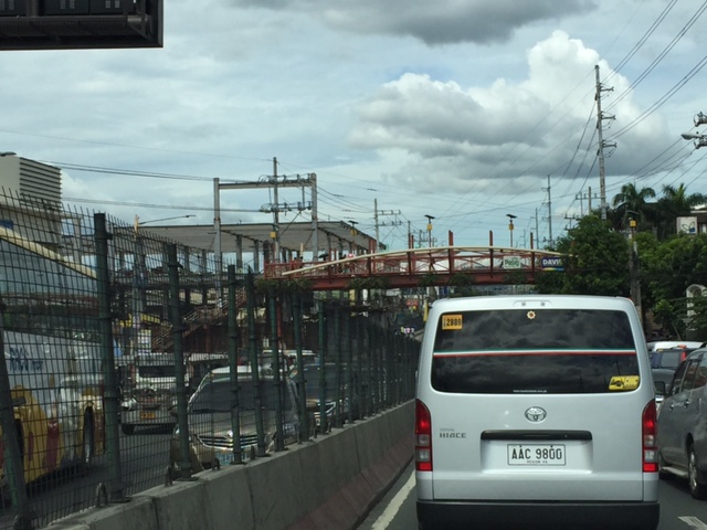
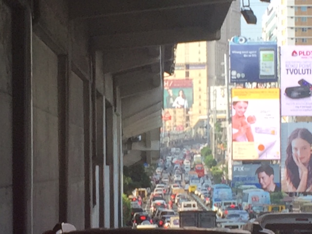 This is EDSA in the mid-afternoon. I took this photo while we were heading back to Quezon City from Makati around 3:30PM. It was not supposed to be this heavy considering people were still at their workplaces, schools or even the shopping center/malls.
There is no quick fix to Metro Manila’s problems. Obviously, the infrastructure that should have been in place decades ago need to be built albeit at a high cost. Our children and grandchildren will likely end up paying for these but there is also the reality that such infrastructure won’t get cheaper in the future. There should also be stricter policies and enforcement to improve the quality of services of public transport. As it is, private transport modes including taxis, the popularity of ridesharing/ridehailing services and the unregulated motorcycle taxis are steadily taking people away from public transport. This is perhaps among the most significant causes of more congestion for the metropolis that needs to be quantified and validated for us to understand and determine what measures need to be taken.
I conclude this post and September with a nice article on walkability:
Steuteville, R. (2017) Why walkability is not a luxury, Public Square, https://www.cnu.org/publicsquare/2017/09/28/why-walkability-not-luxury, last accessed September 29, 2017.
–
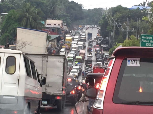
Traffic congestion along Sen. L. Sumulong Memorial Circle
I was on some errands and had to pass through the Sen. Lorenzo Sumulong Memorial Circle from Taktak to the other side of Antipolo near the Lico Circle. The section from Robinsons Antipolo where the Sumulong Circle intersects with Sumulong Highway until C. Lawis Street is being widened and photo below shows the work in progress. The road is a dangerous one especially at night. There are a lot of electric poles in the middle of the newly constructed lanes and power and phone lines dangling in many places. The unfinished parts have a lot of excavations, construction material and debris from the demolished buildings.
 Widened section of Sen. L. Sumulong Memorial Circle
I took the following photos while traffic was at a standstill:
 Initially, it was not so obvious what the cause of congestion was except for the dramatic sag along the road. Both sides appeared to be congested.
 Closer observation showed my direction to be congested up to a certain point whereas the opposite direction across from me was free flowing and traffic build-up along the other side also appeared to be from a certain location at the bottom part of the sag.
It turned out that out of the 6 lanes of the road, only 3 lanes were available to moving traffic – one lane along my way and two along the opposite. Vehicles were parked along 2 lanes of the road in front of the Antipolo City Police Station and 1 lanes across from it. It seems quite ironic considering the police is also tasked with traffic enforcement and management and yet the problem emanated from their station. I am not sure whose vehicles are those that are parked along the road. Perhaps many are owned by police officers? By comparison, the national high school beside the station and the nearby hall of justice did not seem to generate as much vehicular parking as the station. The obvious solution though would be to have an off-street parking lot or facility. Looking at Google Maps, there are some locations along M. Santos Street where a multi-level parking facility can be built but land needs to be acquired first and that can be a difficult task. Another option might be to relocate the main station (i.e., headquarters) elsewhere where there is space for proper facilities including off-street parking. Perhaps they should have a place at the new government center being developed by Antipolo?
–
Why do we need to reduce speeds?
A common observation made of Philippine drivers is that they seem to hesitate from slowing down even at hazardous locations or situations. Note, for example, vehicles approaching an intersection and you will observe that many if not most will not reduce their speeds. Most guilty for me are motorcycle riders who tend to maneuver and even speed up instead of slowing down for a safer approach. Slowing down (i.e., reducing one’s vehicle’s speed) is actually a no-brainer and something that is explicit in any country’s traffic rules and regulations and driver’s handbook.
I saw a lecture on why reducing speeds are important. This is not just from the specific perspective of safety but is explained in favor of mobility and quality of life. Here’s the lecture:
Reducing speeds for better mobility and quality of life by CarlosFelipe Pardo
–
Some issues at Barkadahan Bridge
Perhaps one of the worst places to be in terms of traffic during the morning peak is Highway 2000, and particularly the approach to the Barkadahan Bridge that crosses the Manggahan Floodway. Traffic management at the intersection of the East Bank Road and Highway 2000 is so atrocious that everyone passing the junction would likely incur delays of more than 30 minutes.
The congestion in the area is also attributable to the fact that you have major roads carrying traffic from all over the eastern town of Rizal that are bound for Makati and Taguig (Bonifacio Global City), mostly for offices in those CBDs. These commuters likely use the completed C-6 sections including those at Lupang Arena and the expansion along the Laguna de Bay coast.
 Barkadahan Bridge is a 2-lane structure with significant local traffic such as the tricycles in the photos
 On either side are narrow walkways and it no uncommon for people to walk on the carriageway itself .
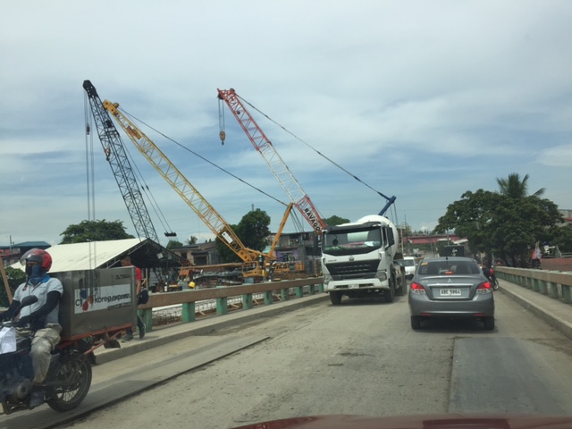 The bridge’s expansion is underway but, from my observation, is taking too much time. Perhaps the contractor is having problems with the foundations for the posts? Or maybe the funds aren’t flowing as required for the effective implementation of the project?
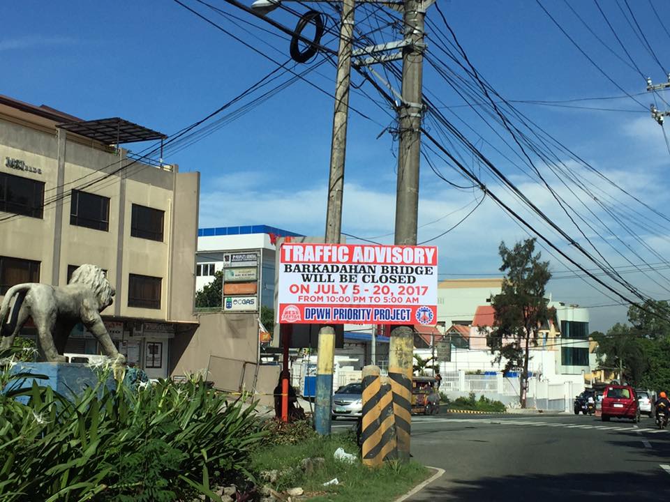 This is an ‘old’ sign now as July 20 is already more than a week ago.
A lot of people look forward to the completion of the bridge but the bigger issue is still the traffic management at the intersection that is also influenced by factors such as the tricycle terminal near the junction and the undisciplined local traffic. The situation is exacerbated by those who counter flow along Highway 2000 and generally get away with it. Perhaps the Municipality of Taytay should get some help in improving their capabilities for traffic management?
–
More major traffic generators along Ortigas Ave. Extension?
There’s another mall being constructed along the westbound side of Ortigas Avenue Extension just before the Lucky Gold Plaza and across from the One Oasis residential enclave. That area is already very congested as will be attested to by the thousands who pass this way especially during the morning rush. Here’s a photo of the mall that is currently under construction as seen from the bridge crossing the Manggahan Floodway. The steel frame on the left and behind the pedestrian bridge is the mall’s.
 That’s another mall being built across the Bali Oasis near the Manggahan Floodway
Among the future major traffic generators that will likely make traffic congestion along Ortigas Avenue worse are the following:
- Residential development across Countryside subdivision
- Town center development near Valley Golf
Commuters using this corridor will likely find traffic worsen (could it really get worse than what it is now?) and traffic schemes by the LGUs along the corridor (i.e., Pasig, Cainta and Taytay) will not be enough to alleviate traffic over the medium to long term. Only a dedicated mass transit line can provide significant improvements for travel along this corridor.
I am still wondering about the mass transit solution for this corridor. There are arguably more people traveling along Ortigas Avenue compared to Marcos Highway that already has Line 2 under construction. I’m sure if you asked people when a mass transit line’s needed along Ortigas, they will reply “years ago”. Being one who has traveled along this corridor since the 1970s (I was a resident of Cainta and then of Antipolo), I can say that traffic indeed has worsened over the last 3 decades. Travel demand management (TDM) measures such as number coding and transport systems management (TSM) schemes such as Pasig’s one-way scheme will not be enough to address the growth along the corridor as they were and are not enough in the first place.
–
Back to school – concerns about congestion and safety
Many roads again are expected to become more congested as school resumes in most parts of the country especially in cities. But while congestion is usually the top issue along roads near many schools, one concern that usually takes a back seat to congestion is safety. Many public schools in the provinces are located along national highways. Many if not most of their students walk to and from school, usually on the carriageway when the shoulders are too rough, dusty or muddy. This situation for students increase the likelihood of their being hit by vehicles using the road. The risk increases because of their exposure to the dangers posed by motor vehicles. Following are a couple of photos showing typical cases at public schools along national roads. Both are in Antipolo City.
 Typical at-grade pedestrian crossing in front of a school. Students in most public schools often commute by walking or taking public transport like jeepneys or tricycles.
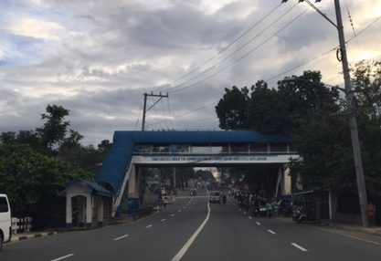 Despite this pedestrian overpass across a public school along Sumulong Highway, most students still prefer to cross on the road rather than go up and down the overpass.
Oftentimes, the seemingly obvious solution of constructing overpasses for safer crossings for students does not pan out as planned or intended. There are many underutilized pedestrian bridges since the natural way is still to cross at-grade. Then there is the issue of providing them safer walking paths or walkways. In both photos above, the sidewalks are only token (“puwede na iyan”) and insufficient for the pedestrian traffic supposed to use them. We need to plan, design and provide such facilities for our pedestrians, especially children, who are marginalized compared to those who have their own vehicles for travel.
–
Resources on traffic calming and recalling statistics on road safety in the Philippines
As I usually post on some interesting and useful articles on transportation and so I just couldn’t resist sharing this find on resources for traffic calming. This is always a timely source of material on how we can improve road safety particularly in residential areas or where there are more pedestrians exposed to transport and traffic. Such exposure increases the likelihood that they may be involved in a crash.
I recall an article from 2015 that appeared on Rappler:
Francisco, K. (2015) Road deaths in PH: Most are motorcycle riders, pedestrians, Rappler, http://www.rappler.com, October 27, 2015.
The WHO Global Status Report on Road Safety 2015 is a good resource for statistics and the report can be easily downloaded along with other information, and in different languages. Here is the entry for the Philippines appearing in the report:

–
Incentives for not driving?
There’s a nice article on Wired that argues for giving an incentive to commuters to give up driving (i.e., using their cars to go to/from workplaces). My only comment here is that it might have better chances elsewhere but not in the Philippines where such incentives often are seen as dole-outs and, despite guidelines or rules for implementation, are likely to be abused or taken advantage of in many offices. This is especially true when cities do not have good quality public transportation and you have low priced motorcycles and cars on sale with the many dealerships. Sad to say but the Philippines is not ready (not mature enough?) for such schemes.
Want commuters to ditch driving? Try giving them cash money
The article is by Aarian Marshall and appeared on the online version Wired last March 26, 2017.
–
Traffic management in Tagaytay?
My recent trip to Tagaytay made me recall why I no longer like the city as much as before when we were frequent visitors for rest and recreation. Two things come to mind whenever we plan a trip to Tagaytay, one is where to stay and the other is when to go. The latter question is usually a no-brainer as we opted to go to Tagaytay on weekdays rather than the weekends. There are much less people during the weekdays and you can still enjoy the city even with one having to deal with the worsening traffic conditions brought about by the intense development along the national highways. The former question is easily answered, too, since there are many good hotels (including bed & breakfast places) in the city.
Traffic though has worsened in this city that probably has tourism as its top industry. It has attracted a lot of developers who seem to have gobbled up a lot of land for what has become intense development. Surely they were targeting a market comprised of people wanting to own property in Tagaytay. The high rise condominiums address the demand for a view of Taal Lake and Volcano. The commercial developments are supposed to cater to the needs (shopping?) of tourists. The city seems to have neglected the fact that its transportation system’s carrying capacity (never mind for this article the capacities for other critical resources like water) cannot handle the trip generation attributed to these developments. And so its transport problems, again basically rooted on trip generation, are exacerbated by limited capabilities for traffic management. [The capacity seems to be there given all the staff manning the Tagaytay rotunda.]
A colleague opined that perhaps traffic management here is limited, too, by the options Tagaytay has in terms of management measures. You basically have a major intersection, a rotunda, where practically much of traffic converges. These include traffic along the Tagaytay-Nasugbu Road, which includes a lot of vehicles coming from or going to the Sta. Rosa-Tagaytay Road. And there are vehicles taking the Aguinaldo Highway. Traffic personnel seem helpless as they attempt to manage traffic movements. Their approach though is haphazard and only results in very long queues extending outward along all the intersection legs.
 Traffic jam against the backdrop of a gigantic tarp with greetings from the ruling political dynasty in the city
 The Tagaytay – Nasugbu Highway is terribly congested due primarily to the Ayala mall. Not seen in the photo is the barrier that stretches from the rotonda to beyond Lourdes Church that forces all traffic from the west head to the rotonda to make a turn.
 Vehicles coming in from Aguinaldo Highway are backed up. There is also a new mall under construction and opening soon that is too close to this major junction in Tagaytay.
I wonder if the major trip generators (i.e., malls and high density residential developments) were required to do impact studies before the projects were approved for implementation. There’s really not so much in terms of traffic circulation or transportation improvements that can be undertaken given the linear form of the city and the limited road network available for planners. I am curious too see for myself what recommendations were made by these studies in order to alleviate the detrimental impacts they now have on transportation in Tagaytay.
–
Responding to the transport impacts of road crashes
Last March 9, traffic was terrible along Marcos Highway and roads connecting to it including Imelda Avenue and Sumulong Highway due to a truck that slammed into the scaffolding of the Line 2 Extension across the Sta. Lucia Mall, and barely missing the newly constructed column supporting the girders and elevated tracks of Line 2.
 [Photo not mine but sent by an officemate who was glad to have taken his motorcycle that day instead of commuting by car.]
Following are comments I captured from Waze as I tried to get information about the traffic situation:


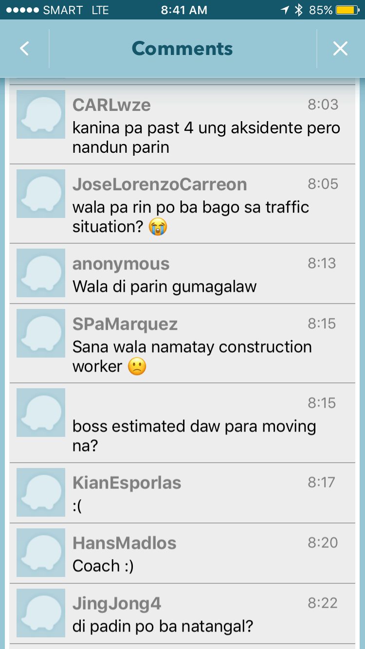

It is very clear from travelers’ comments that most were frustrated and many were angry about what seemed to be a very slow response from authorities in clearing the crash site and getting traffic to move faster. I myself wondered how a crash like this with its impacts manifesting in severe congestion along major roads was not dealt with as urgently as possible by so many entities that were not without capacity to act decisively. The front liner should have been the Metropolitan Manila Development Authority (MMDA) and there were at least four local government units directly affected by the congestion: Pasig, Marikina, Cainta and Antipolo. Surely, these LGUs could have done more if the MMDA couldn’t, in order to resolve the problem? If the availability of heavy equipment was an issue, weren’t there available equipment from Line 2 contractor, DMCI, or perhaps from the construction sites nearby (Ayala is constructing a huge mall near the area.)? Surely, they could lend a payloader or mobile crane that can remove the truck or at least help unblock the area?
I finally decided to turn back and work from home instead that day. Later, I learned that authorities had to stop traffic along Marcos Highway around 11:00 AM in order to tow the truck and clear the area for traffic to normalize. I hope this serves as a lesson in coordination among government entities and that future incidents like this will not results in a “carmaggedon” like Friday’s congestion. One thing that also became obvious is that travelers passing the area are all dependent on road-based transport and the primary reason why a lot of people were affected by the crash. The expanded operations of the Line 2, whenever that will be, will surely change transport in these areas and for the better.
–
