
Home » Posts tagged 'Marcos Highway'
Tag Archives: Marcos Highway
After getting engrossed with EDSA, is Marcos Highway next?
If you monitored the news articles and social media post over the past two decades, there seems to be an obsession for EDSA. Circumferential Road 4 is the busiest corridor in Metro Manila, stretching across several jurisdictions including Caloocan, Quezon City, Mandaluyong, Makati and Pasay City. Aside from the MMDA, national agencies like the DPWH and DOTr have been heavily involved in traffic schemes and transportation infrastructure development along the corridor. These include variants of the travel demand management (TDM) scheme commonly called number coding. Since the 1990s, there’s the Line 3 and several overpasses/flyovers and underpass that have been constructed along major intersections (e.g., EDSA-Shaw, EDSA-Ortigas, EDSA-Kamuning, EDSA-Quezon Avenue, etc.). Nowadays, people are more into the EDSA carousel and most recently the pavement rehabilitation for EDSA. It seems we failed to realize that EDSA is just one corridor. There are others that also demand attention including those in other parts of the country.
Recently, a “carmaggedon” along Marcos Highway was in the headlines or shall I say was trending in social media. There was a lot of excitement for what has been a recurring nightmare to those residing along the corridor. I recall something worse occurred more than 15 years ago (pre-Ondoy), before social media and influencers and digital creators. At the time, Line 2 terminated at Santolan Station. And even back then, the MMDA insisted on playing with their U-turn scheme. I don’t recall a more in-depth study that could have involved micro-simulation modeling being done for the corridor. And since then, populations and traffic have grown steadily and as I’ve written about previously, the extension of Line 2 to Masinag seems to have had little impact on traffic. And so here we are with the MMDA still insisting on tweaking their U-turn schemes and relying mainly on gut-feel instead of a more scientific approach that may actually lead to more sound solutions for the corridor.
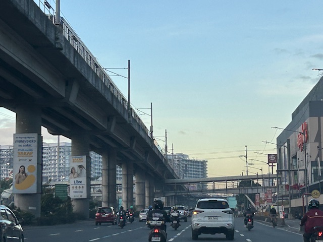
 Approach to Marcos Highway from Felix Avenue – that’s the elevated Line 2 superstructure behind the Cainta arch.
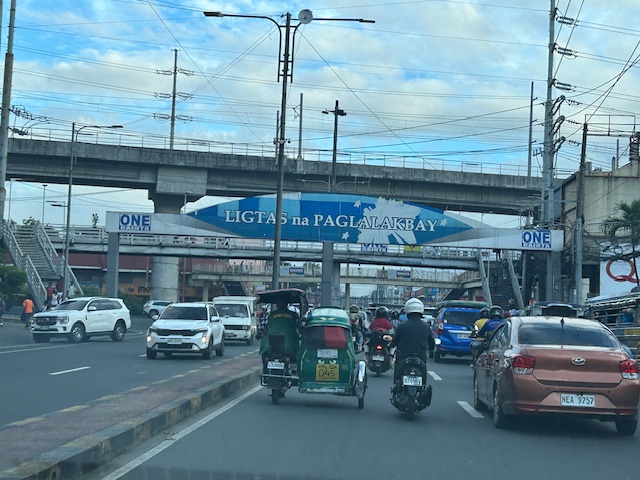
 Intersection of Marcos Highway, Felix Avenue and Gil Fernando Avenue – there’s a major foot bridge installed here so people can cross at the intersection, which used to be a signalized junction before the MMDA opted for U-turns for Marcos Highway sections under its jurisdiction.
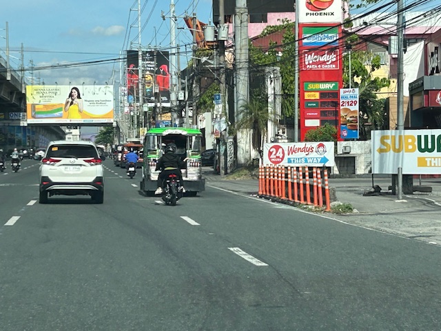
 Marcos Highway section fronting the Ayala Feliz Mall – the MMDA has played with the location of the U-turn slots in the vicinity of the Marcos Highway-Amang Rodriguez-J.P. Rizal intersection as they tried to determine the “optimum” locations of these slots.
Of course, there is also the case of Commonwealth Avenue. How many carmaggedons have occurred along that corridor? Isn’t it an everyday thing there? And there’s also Ortigas Avenue Extension and many other roads and streets where congestion seems to have been accepted as the norm. How do we make travel easier for most people? How do we improve commutes given the constraints and realities concerning behavior and choices?
–
Bollards along Marcos Highway
I noticed that there are new bollards installed along Marcos Highway and particularly along the curbs at either side of the road. These were installed only recently, perhaps last month, nut I only got a few photos the other day. Its not safe to take photos while one is driving so I asked the wife to take a few ones that I could use here and perhaps also in some of the lessons I teach.
 These bollards are installed along the curb where a couple of fatal crashes occurred in the past months.
The bollards are probably there to help improve road safety. They are reflectorized to you can’t miss them at night. Immediately behind them though are concrete barriers so hitting these will definitely damage the vehicle with a possibility of serious injuries to the vehicle occupants if not fatalities. Could there be a safer design intervention here? Perhaps that curbside lane can be converted into a protected bicycle lane. The barrier and the bike lane itself will be a buffer zone between motor vehicle traffic and active transport including pedestrians.
–
Traffic management schemes for the Marcos Highway bridge rehab
The rehabilitation of the Marcos Highway Bridge in Marikina has necessitated traffic management schemes at the bridge itself and along alternative routes to alleviate congestion in the area. These are collectively called traffic or transport systems management (TSM) schemes with the objective of optimising existing infrastructure and resources without necessarily building something entirely new. These are quite different from travel demand management (TDM) schemes that include number coding and truck ban policies that are already being implemented (though Marikina does not implement the number coding scheme).
 Traffic build-up at the approach to the intersection with FVR Road (To Riverbanks). This is now a signalised intersection as traffic from Blue Ridge/White Plains is now allowed to cross to FVR Road.
 Using the route via FVR Road (Riverbanks) means you don’t have to cross the Marcos Highway Bridge and travellers will merge with those who crossed the bridge just before the Line 2 Santolan Station.
 In the mornings, one lane each is allocated for either the eastbound or westbound traffic. That’s practically a total of 3 lanes (+2 lanes westbound for the SM Marikina Bridge) for the westbound direction and a single lane for the eastbound side. This is logical given the directional distribution of traffic at this time of day and the alternative routes already available to travellers.
Here are a few photos taken on a night time drive. Note that this was taken by a passenger. Don’t even try doing this (taking photos) while driving a vehicle, and especially not while on a motorcycle.
 Entrance to the bridge right after Maj. Dizon – this part is not affected by the rehab works but vehicles position themselves to shift towards the left side, which is the usable part of the bridge.
 Both lanes of the westbound side of the bridge are used for eastbound traffic. Westbound traffic are all along the SM Marikina bridge for a total of 2 lanes each for either direction of flow. The cones are not removed for practicality since they would have to be installed for the morning when one lane is allocated for the westbound traffic.
 Vehicles shift to the right to return to the correct lanes for eastbound traffic along Marcos Highway at the Santolan area. Note the westbound vehicles shifting towards the underpass and SM Marikina on the left.
–
On the impacts of the closure of the Marcos Highway Bridge
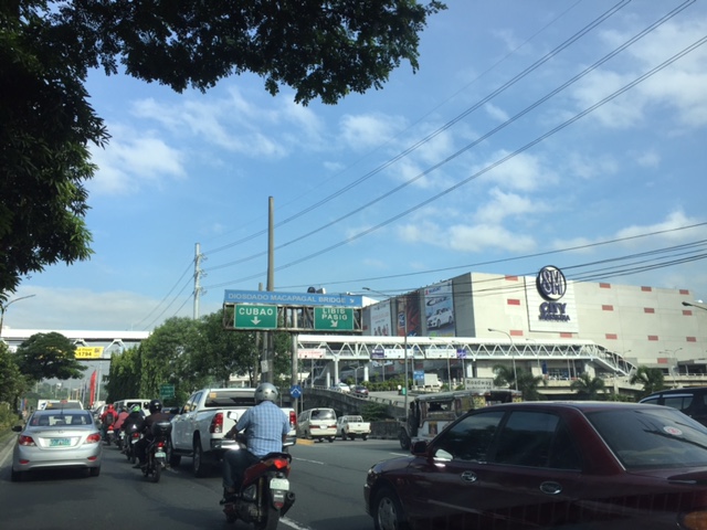
The Marcos Highway Bridge was scheduled for rehabilitation in the next four months starting last week. While it will not be totally closed to traffic, the scheme reducing its capacity will surely lead to congestion along Marcos Highway. This congestion should be expected along other roads as well, as travellers, particularly those taking private transport will be using alternative routes in order to avoid this area. Those coming from the east will likely go through Marikina City via the parallel route comprised of Sumulong Highway and A. Bonifacio Avenue. Others will turn to A. Rodriguez (Ligaya). And perhaps others may go via Ortigas Avenue Extension. These alternative routes correspond to the other bridges crossing the Marikina River connecting the Rizal province and part of Marikina and Pasig to Metro Manila.
 A photo of the bridge prior to its partial closure
I will write more on this topic once I get more information on what’s happening to the traffic in the area. Meanwhile, I do know that my usual alternative route via Marikina and Tumana seems to have more than the usual traffic during my commute. While it is easy to attribute this to the partial closure of the Marcos Highway bridge, this could also be just a normal variation in the typical daily traffic for that route.
–
The ill-located terminal at Ligaya along Marcos Highway
There is a newly constructed public transport terminal in what is popularly known as the Ligaya area along Marcos Highway in Pasig City. The terminal is right across from the new Ayala Feliz Mall. The terminal is mostly unused or under-utilised. The jeepneys and UV Express vehicles that were supposed to use the terminal seldom go there as the natural stop for most coming from Pasig to Marikina would be closer to the junction of Marcos Highway with Amang Rodriguez Avenue. There is also the U-turn slot nearby where many passengers dare to cross to in order to catch a ride. Sinasalubong ng mga tao ang jeepney na lumiliko dito and the traffic enforcers in the area generally turn a blind eye to this.
 The practically empty terminal during evenings
Late at night, the terminal is dark with the lights turned off. Most times I pass by the area in the mornings and afternoons, there are few, if any, PUVs at the terminal and you don’t see a congregation of a lot of passengers there as with other terminals. Did Ayala make a mistake with this terminal? For one, it is known already that while this area is a transfer point for many passengers, the location of the terminal with respect to the established U-turn slots make it unsuitable and undesirable for most PUVs. Then there is the impending operations of the Line 2 Extension whose nearest station will be hundreds of meters away across Robinsons Metro East and Sta. Lucia Mall. I think Ayala needs to construct a physical connection to the terminal if only to increase the number of people going there and therefore attract PUVs. Finally, the area is not a terminus (or last stop) for PUVs so it doesn’t make sense for them to spend time there except perhaps during off-peak periods (i.e., for rest). However, it is not attractive even for the latter since there seems to be no amenities including stores or maintenance shops to support PUVs.
–
Marcos Highway-Felix Avenue-Gil Fernando Avenue pedestrian overpass
Here’s are some photos of the pedestrian overpass structure at the intersection of Marcos Highway, F. Felix Avenue (formerly Imelda Avenue) and Gil Fernando Avenue (formerly A. Tuazon Avenue).
 Here’s a view of Marcos Highway and the elevated Line 2 Extension from the structure crossing Felix Avenue between Soliven/Tropical and Sta. Lucia. Also shown is the overpass crossing Marcos Highway.
 View towards Sta. Lucia and Robinsons Metro East
 Stairs to Sta. Lucia – notice the gap in the railings along the elevated Line 2 superstructure? That is where the Emerald Station will be constructed.
–
Vermont Royale pedestrian overpass
There was a comment on a previous article asking if the pedestrian overpass across Vermont Royale along Marcos Highway is already usable. The photo in that article showed a still-to-be modified overpass. Following are photos taken last Sunday of the overpass. It shows the lowered mid-section passing under the Line 2 extension structure.
 The modified pedestrian overpass across Vermont Royale along Marcos Highway
 That’s a pedestrian and a cyclist using the overpass
–
Responding to the transport impacts of road crashes
Last March 9, traffic was terrible along Marcos Highway and roads connecting to it including Imelda Avenue and Sumulong Highway due to a truck that slammed into the scaffolding of the Line 2 Extension across the Sta. Lucia Mall, and barely missing the newly constructed column supporting the girders and elevated tracks of Line 2.
 [Photo not mine but sent by an officemate who was glad to have taken his motorcycle that day instead of commuting by car.]
Following are comments I captured from Waze as I tried to get information about the traffic situation:


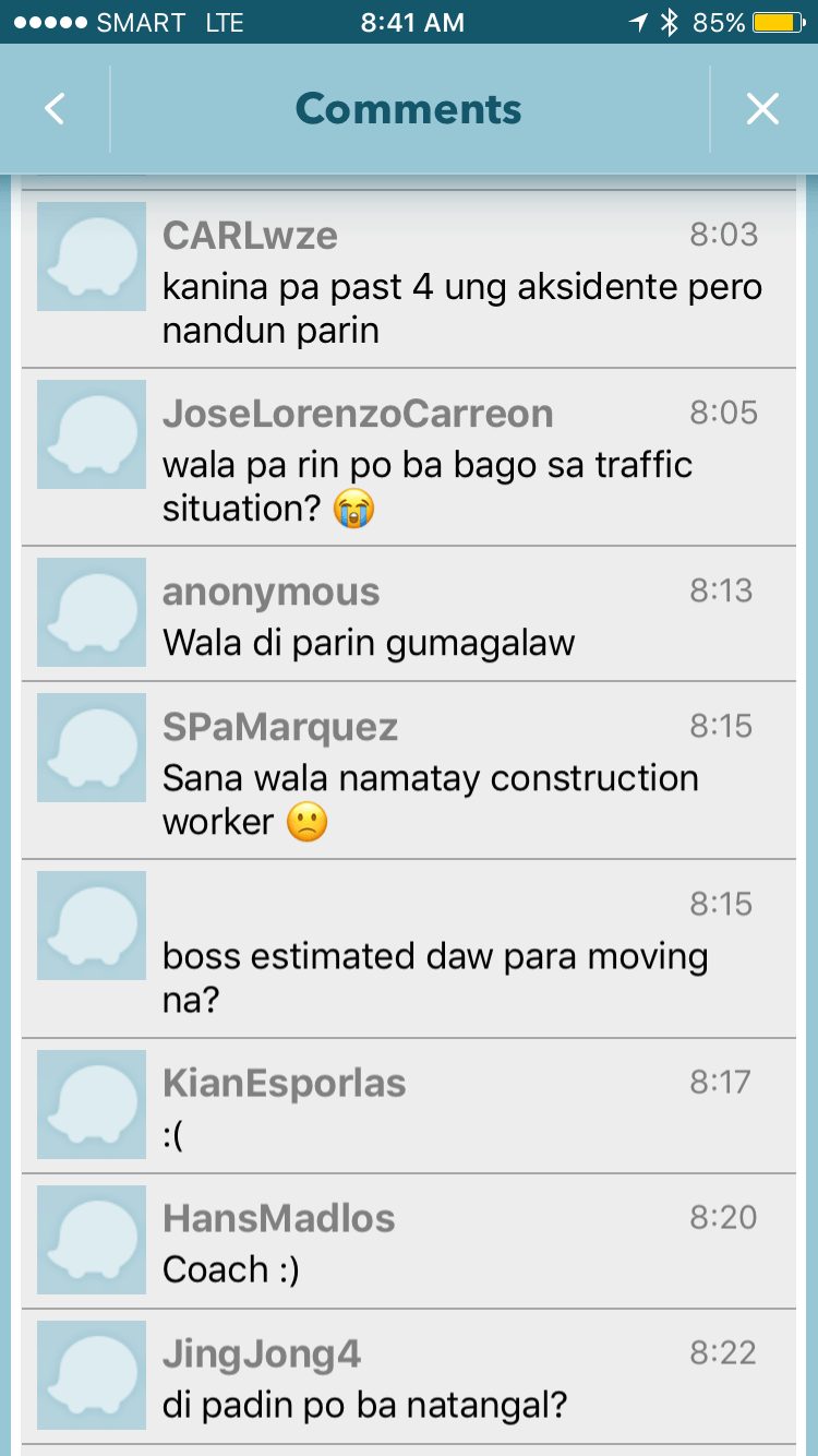
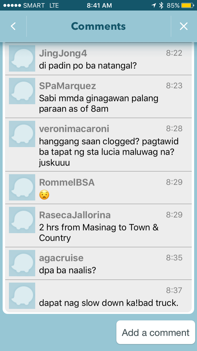
It is very clear from travelers’ comments that most were frustrated and many were angry about what seemed to be a very slow response from authorities in clearing the crash site and getting traffic to move faster. I myself wondered how a crash like this with its impacts manifesting in severe congestion along major roads was not dealt with as urgently as possible by so many entities that were not without capacity to act decisively. The front liner should have been the Metropolitan Manila Development Authority (MMDA) and there were at least four local government units directly affected by the congestion: Pasig, Marikina, Cainta and Antipolo. Surely, these LGUs could have done more if the MMDA couldn’t, in order to resolve the problem? If the availability of heavy equipment was an issue, weren’t there available equipment from Line 2 contractor, DMCI, or perhaps from the construction sites nearby (Ayala is constructing a huge mall near the area.)? Surely, they could lend a payloader or mobile crane that can remove the truck or at least help unblock the area?
I finally decided to turn back and work from home instead that day. Later, I learned that authorities had to stop traffic along Marcos Highway around 11:00 AM in order to tow the truck and clear the area for traffic to normalize. I hope this serves as a lesson in coordination among government entities and that future incidents like this will not results in a “carmaggedon” like Friday’s congestion. One thing that also became obvious is that travelers passing the area are all dependent on road-based transport and the primary reason why a lot of people were affected by the crash. The expanded operations of the Line 2, whenever that will be, will surely change transport in these areas and for the better.
–
Updates on the Line 2 Extension: What’s next?
Marcos Highway is part of my regular commuting route and so I have been able to observe the progress of the construction of the elevated tracks for the extension of Line 2. The contractor, DMCI, is nearing the completion of their part of the project. Unfortunately, the stations and the electrical/power systems for the extension have not been bidded out by the DOTr and so there are not a few doubts whether the extension will be operational by 3rd quarter of 2017, which is the original completion date for the whole project. The construction of the two stations alone are expected to take some time and also will have a big impact on transport and traffic despite the construction sites being more concentrated around the stations at Emerald and Masinag. Here are a couple of photos showing what it looks like along Marcos Highway.
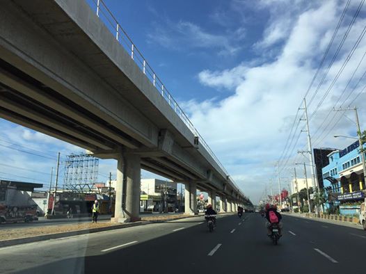 DMCI has almost completed clearing the stretch of Santolan to Masinag of their equipment. The barriers that delineated their work space are mostly gone, freeing up a lane each along either side of Marcos Highway. This has eased traffic along this major thoroughfare connecting Metro Manila to the east.
 The pedestrian overpass across Vermont Royale has been retrofitted so the center section passes under the Line 2’s structure.
Timing is of the essence for the two additional stations of Line 2. As I said, the projected completion and start of operations was 3rd quarter of 2017. Of course, the last quarter of this year would still be most welcome but further delays mean more losses on the part of commuters and, overall, the government. Perhaps it was a mistake for the previous administration to have not included the stations in the package that DMCI eventually got and now has almost completed? Maybe the current administration should expedite the remaining parts of the Line 2 extension. This should prove how serious the current government is with its promises for better public transport (i.e., mass transport).
–
Another look at Marcos Highway overpasses – Part 3
The overpass at SM City Marikina is a bit more complex than what it looks like across the bridge. Here are some photos of the footbridge connecting the mall with the Santolan Station of Line 2:
 The overpass is a very long one and provides users with a partially covered walkway connecting to the LRT Line 2 Santolan Station. I say ‘partially’ because the roof over the overpass extends only across Marcos Highway.
 Note the covered bridge is only until the other side of Marcos Highway. From there it is an open overpass as shown at the left in the photo above.
 A closer look at the SM Marikina overpass shows just where the cover ends. There are stairs here leading to the loading/unloading bays across from the mall. There is also a path that leads to stairs to the public transport terminal under the bridge. There is a sign with a blue background in the photo stating the terminal is named after a former MMDA Chair who was also a mayor of Marikina and currently one of its congressmen.
–
