
Home » Posts tagged 'Pasig' (Page 2)
Tag Archives: Pasig
The Barkadahan Bridge situation
The Barkadahan Bridge is currently undergoing rehabilitation. To be accurate, the old bridge is being rehabilitated and upgraded/retrofitted to be able to carry the traffic projected to use it being a vital link between the Province of Rizal and Metro Manila via Pasig and the C-6 corridor. The bridge is named after the “friendship” established among Rizal municipalities and Pasig City for an area that has been subject of a territorial dispute among them. These are the municipalities of Cainta and Taytay (Rizal Province) and the city of Pasig. The bridge spans the Manggahan Floodway, much of which is in Pasig City.
To increase the capacity for this crossing, which is the most direct route to C-6 and popular among many headed to Taguig/BGC and Makati, a new bridge had been constructed to the south of the old one. The older one had 2 traffic lanes and was no longer sufficient for the volume of vehicles crossing it after the expansion of C-6 resulting to it steadily gaining more users over the years. Use of this route cut down travel times between Rizal and BGC and Makati by at least 30 minutes based on our experiences using the route.
Late last year as far as I could recall, the new bridge opened and immediately increased capacity but then congestion quickly set-in due to two factors: the traffic management at the intersection with the East Bank Road and the constrained (two-lane, two-way) leg of Highway 2000. Add to this the lack of discipline by local traffic in the form of tricycles and motorcycles counter-flowing in the area.
Earlier this year, signs were posted around Rizal about the then impending project for the rehabilitation of the old bridge. The signs advised for most travellers to avoid using the Barkadahan Bridge due to the congestion in the area because of the project. It turns out that what was thought by most as a project retrofitting the old bridge alone was actually a bigger one involving increasing the capacity of the Highway 2000 leg of the intersection with the East Bank Road. Following is a photo posted at the official Facebook page of the Rizal Provincial Government showing the demolition of buildings and other structures along the Highway 2000 leg. The photos were taken from the new Barkadahan Bridge approaching the intersection, the southbound direction of the East Bank Road, and from the westbound side of Highway 2000.
 Demolition and clearing of ROW for the expansion of Highway 2000 in relation to Barkadahan Bridge [Photo collage from the Lalawigan ng Rizal Facebook page]
From the photos above, it is clear that at least 2 lanes will be added to Highway 2000 and that this leg will soon be well-aligned with the Barkadahan Bridge, which will also have a total of 4 lanes. Hopefully, this project will be completed soon and within the year (before December?) in order to alleviate the commuting woes of Rizalenos working in the BGC and Makati CBD areas. Of course, that goes without saying that there is also a need to optimise the traffic signals at the intersection and to strictly enforce traffic rules and regulations vs. erring motorists in the area.
–
Traffic management schemes for the Marcos Highway bridge rehab
The rehabilitation of the Marcos Highway Bridge in Marikina has necessitated traffic management schemes at the bridge itself and along alternative routes to alleviate congestion in the area. These are collectively called traffic or transport systems management (TSM) schemes with the objective of optimising existing infrastructure and resources without necessarily building something entirely new. These are quite different from travel demand management (TDM) schemes that include number coding and truck ban policies that are already being implemented (though Marikina does not implement the number coding scheme).
 Traffic build-up at the approach to the intersection with FVR Road (To Riverbanks). This is now a signalised intersection as traffic from Blue Ridge/White Plains is now allowed to cross to FVR Road.
 Using the route via FVR Road (Riverbanks) means you don’t have to cross the Marcos Highway Bridge and travellers will merge with those who crossed the bridge just before the Line 2 Santolan Station.
 In the mornings, one lane each is allocated for either the eastbound or westbound traffic. That’s practically a total of 3 lanes (+2 lanes westbound for the SM Marikina Bridge) for the westbound direction and a single lane for the eastbound side. This is logical given the directional distribution of traffic at this time of day and the alternative routes already available to travellers.
Here are a few photos taken on a night time drive. Note that this was taken by a passenger. Don’t even try doing this (taking photos) while driving a vehicle, and especially not while on a motorcycle.
 Entrance to the bridge right after Maj. Dizon – this part is not affected by the rehab works but vehicles position themselves to shift towards the left side, which is the usable part of the bridge.
 Both lanes of the westbound side of the bridge are used for eastbound traffic. Westbound traffic are all along the SM Marikina bridge for a total of 2 lanes each for either direction of flow. The cones are not removed for practicality since they would have to be installed for the morning when one lane is allocated for the westbound traffic.
 Vehicles shift to the right to return to the correct lanes for eastbound traffic along Marcos Highway at the Santolan area. Note the westbound vehicles shifting towards the underpass and SM Marikina on the left.
–
On the impacts of the closure of the Marcos Highway Bridge
The Marcos Highway Bridge was scheduled for rehabilitation in the next four months starting last week. While it will not be totally closed to traffic, the scheme reducing its capacity will surely lead to congestion along Marcos Highway. This congestion should be expected along other roads as well, as travellers, particularly those taking private transport will be using alternative routes in order to avoid this area. Those coming from the east will likely go through Marikina City via the parallel route comprised of Sumulong Highway and A. Bonifacio Avenue. Others will turn to A. Rodriguez (Ligaya). And perhaps others may go via Ortigas Avenue Extension. These alternative routes correspond to the other bridges crossing the Marikina River connecting the Rizal province and part of Marikina and Pasig to Metro Manila.
 A photo of the bridge prior to its partial closure
I will write more on this topic once I get more information on what’s happening to the traffic in the area. Meanwhile, I do know that my usual alternative route via Marikina and Tumana seems to have more than the usual traffic during my commute. While it is easy to attribute this to the partial closure of the Marcos Highway bridge, this could also be just a normal variation in the typical daily traffic for that route.
–
The unsafe situation at the U-turn slot near Ligaya (Feliz Mall)
I have been observing the U-turn slot at Ligaya just across from the Ayala Feliz Mall. Most of the times I pass by the area on my way home in the afternoons or evenings, I see that there are many people there meeting jeepneys head-on and getting ahead of other passengers waiting to get a ride who won’t risk crossing the busy Marcos Highway for this. There are usually no enforcers (MMDA or Pasig’s) in that area. Most of them congregate at the U-turn slot before this (across from the Mariposa motel) to flag down vehicles whose drivers are violating the number coding scheme. I finally had the opportunity to get a couple of photos care of the wife who took the photos as we turned to head to Feliz.
 The photo shows people crowding the area at the U-turn slot in order to have a better chance at getting a jeepney ride. Many jeepneys turning here are actually cutting trips. So there are two clearly illegal activities going on here that the MMDA or Pasig City enforcers turn a blind eye to. The situation regarding the commuters is unsafe and requires attention. There is supposed to be a transport terminal across from the mall. And don’t mind the political ad (yes that stupid one in the background by an opportunist running for the senate).
 Here is another photo of the people at the U-turn slot. Note that most if not all are worker types who are more likely to be risk takers; meeting jeepneys head-on (sumasalubong) and hanging on (sabit) if all seats are taken. Allowing or tolerating this means other people who don’t want to risk it cannot get a ride.
A footbridge will soon be constructed at the area but this may not solve this concern as it only addresses the crossing safety issue in the area. And so we urge those responsible for enforcing traffic rules and regulations to do their job and address this problem that concerns both safety and public transportation. Hindi lang naman number coding violations lang ang dapat tutukan ng mga enforcers. There are other more serious and safety-related concerns that they need to work on.
–
The Ortigas Center bike lanes, complete streets and road diets
The MMDA recently stated they were planning to apply the road diet concept to EDSA by narrowing the current lane widths in order to add one lane per direction. While the idea seems to of good intention, the mention and application of road diet is flawed. I have previously shared an article on social media showing the definition and examples of complete streets:
Clearly, complete streets are for the benefit of everyone (i.e., inclusive) and not biased for motor vehicles. Here is a photo of F. Ortigas Ave. at the Ortigas Center in Pasig City showing the correct application of the Complete Streets and Road Diet concepts to an urban street. Note the elements for cycling and walking that are very prominent in the re-design of the street.
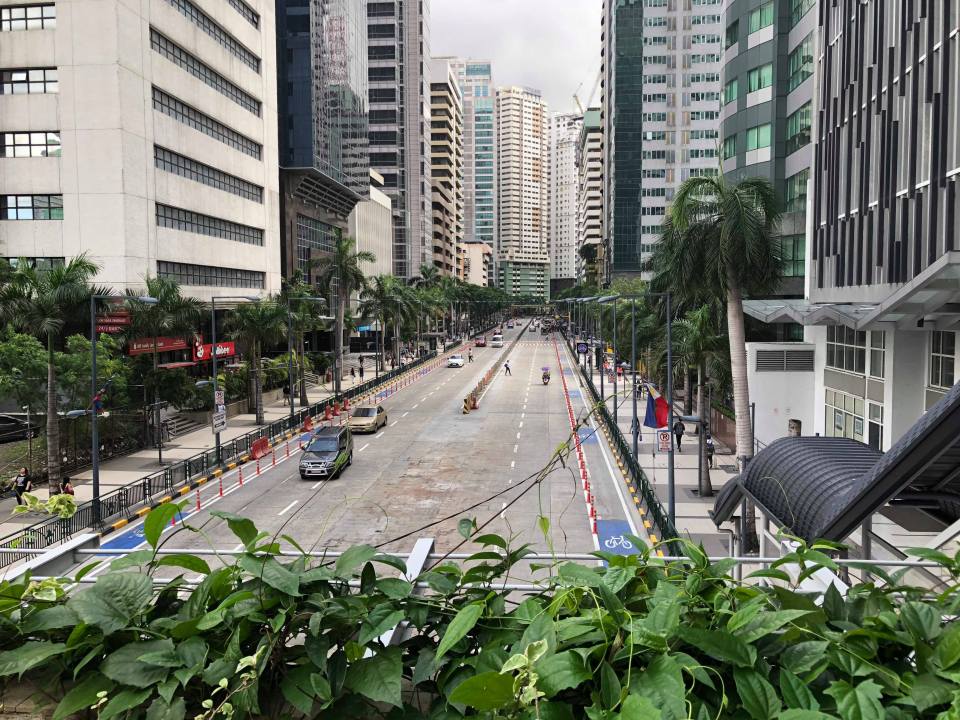 Protected bike lanes at either side of F. Ortigas Ave. at the Ortigas Center
We hope to see more of these re-designs in many other cities and towns in the Philippines. It is not a really difficult concept to apply or adopt as technically these are not complicated. However, there needs to be a change in the mindset of planners and engineers when they do these exercises considering how car-oriented our designs are. It is easy to say we want more people-oriented transportation facilities until it dawns on us how dependent we are on cars and resist the efforts to realise more sustainable designs.
–
The Julia Vargas Avenue protected bike lane
I thought I already posted an update on the Julia Vargas Avenue in Pasig City. It turned out I was only able to upload photos on my folder but wasn’t able to get to writing about the bike lane. And so we conclude the year 2018 with a positive post of something we would like to see more in 2019 and beyond. We are hopeful that the protected bike lanes along Julia Vargas Avenue, connecting C-5 with the Ortigas Center, will expand and that this example along those of its predecessor bikeways in Marikina and Iloilo would be replicated across the country particularly in highly urbanised cities.
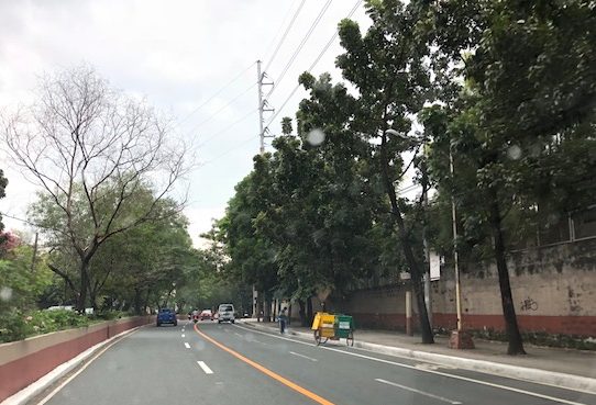
 A view of the westbound bike lane along Julia Vargas at the Ortigas Center. Note that the eastbound bike lane (visible in this photo) is not similarly protected vs. motor vehicle encroachments. It would be preferable for that lane to be protected, too. Parang bitin pa tuloy ang effort nila.
 Another view of the protected bike lane along the westbound side of Julia Vargas Avenue in contrast with the obviously congested lanes available for motor vehicles.
The middle lanes of the carriageway are wide and can accommodate motorcycles though the latter always seem to prefer filtering or splitting the lanes. The median lanes are generally for low occupancy vehicles (less than 3 passengers) while the middle ones are for high occupancy vehicles (3 or more passengers) including UV Express vans and buses.
Happy New Year to all!
–
The ill-located terminal at Ligaya along Marcos Highway
There is a newly constructed public transport terminal in what is popularly known as the Ligaya area along Marcos Highway in Pasig City. The terminal is right across from the new Ayala Feliz Mall. The terminal is mostly unused or under-utilised. The jeepneys and UV Express vehicles that were supposed to use the terminal seldom go there as the natural stop for most coming from Pasig to Marikina would be closer to the junction of Marcos Highway with Amang Rodriguez Avenue. There is also the U-turn slot nearby where many passengers dare to cross to in order to catch a ride. Sinasalubong ng mga tao ang jeepney na lumiliko dito and the traffic enforcers in the area generally turn a blind eye to this.
 The practically empty terminal during evenings
Late at night, the terminal is dark with the lights turned off. Most times I pass by the area in the mornings and afternoons, there are few, if any, PUVs at the terminal and you don’t see a congregation of a lot of passengers there as with other terminals. Did Ayala make a mistake with this terminal? For one, it is known already that while this area is a transfer point for many passengers, the location of the terminal with respect to the established U-turn slots make it unsuitable and undesirable for most PUVs. Then there is the impending operations of the Line 2 Extension whose nearest station will be hundreds of meters away across Robinsons Metro East and Sta. Lucia Mall. I think Ayala needs to construct a physical connection to the terminal if only to increase the number of people going there and therefore attract PUVs. Finally, the area is not a terminus (or last stop) for PUVs so it doesn’t make sense for them to spend time there except perhaps during off-peak periods (i.e., for rest). However, it is not attractive even for the latter since there seems to be no amenities including stores or maintenance shops to support PUVs.
–
Some updates on the Line 2 Extension
I just wanted to post a couple of photos showing the progress of the Line 2 Extension construction work. There are two stations along the extension including the future end station before the Masinag Junction (intersection of Marcos Highway and Sumulong Highway).
 Ongoing construction of the Line 2 Masinag Station just across from SM City Masinag in Antipolo City, Rizal – there are actually 3 usable lanes with only the middle being a full lane, the other two have concrete barriers encroaching along the site as shown in the photo.
 Ongoing construction of the Emerald Station across from both the Sta. Lucia and Robinsons Metro East malls at the boundaries of Pasig City, Marikina City and Cainta – the construction site here is longer than the one for Masinag but has wider spaces for traffic. Volumes, however, are significantly heavier than at Masinag so this area can easily become congested with traffic often stretching past the PLDT office along the westbound side and Ligaya along the eastbound side.
I will post more about the progress of construction for these stations in the future especially as it would be interesting to see the actual forms of the stations.
–
On the Pasig HOV traffic experiment
Someone shared a post about a traffic scheme they will be implementing along Julia Vargas Avenue in Pasig City. The proposal is for the avenue to have a high occupancy vehicle (HOV) lane where vehicles with 4 or more occupants are to take one lane and all other vehicles the other. I am not entirely sure about the objective other than to promote high occupancies for vehicles. However, it would be nice to see how travellers will be behaving (e.g., complying) and how Pasig (with MMDA?) will be enforcing this scheme.
This is what a segment of Julia Vargas currently looks like with 2 wide lanes designated for motor vehicles (separated by the solid yellow line) and one narrow lane for cyclists (adjacent to the shoulder):
The intent is good but as a major link the scheme can be quite confusing especially for those who are not necessarily frequent users of this road. I assumed the yellow line was painted by the DPWH but it seems it was by Pasig. Perhaps they should have removed the old markings? Or maybe better if they rationalised the carriageway width to accommodate 3 lanes for motor vehicles and 1 wider lane for bicycles? From the photo above, it appears to me that it is possible to have 2 narrow lanes for general traffic and one wider lane for HOVs (in this case defined as having 4 or more occupants) and public utility vehicles. This configuration maximises the capacity of the road while having a the “best” lanes allocated for HOVs and bicycles.
I wish them success on this social experiment. Perhaps there can be valuable learnings from this including the need for connectivity to other links as well.
–
Congestion along C-6 and potential for a public transit corridor
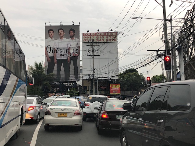
We begin February with a post on a road that’s becoming more popular as a major (as opposed to alternate) route to Bonifacio Global City (BGC) and Makati CBD – Circumferential Road 6. I took the following photo at the approach to the Nagpayong Bridge that is current has only 2 lanes (1 per direction). Another bridge is being constructed along the existing one that will increase capacity for the Pasig River crossing to 2 lanes per direction. This is similar to what was done to the Barkadahan Bridge crossing the Manggahan Floodway in Taytay, Rizal.
The volume of road vehicle traffic is steadily increasing along C-6. The adjacent land use offers a lot of potential for development (hopefully planned) that will feed more traffic along what will become a major thoroughfare in the near future. The land I am referring to are the reclamations on the side of Laguna de Bai along C-6 that are under the jurisdiction of Taguig and similar developments on the opposite side on what was once swampy or marshlands. One wonders if Taguig has a plan for all this or if the city is turning a blind eye and just letting developers do what they want. Most seem to be residential subdivisions and industries-related with a sprinkling of mainly small to medium-sized commercial developments.
Again, I think national and local governments should consider making this a public transport corridor by introducing formal public transport in the form of a scheduled bus service stretching from, say, Bicutan Interchange to Taytay Public Market. The demand along this corridor is steadily rising and only a better connection to C-5 limits an even steeper increase in traffic volume along C-6. The time is now in order to condition commuters about the system and to the unwanted congestion experienced along major roads in the metropolis.
–
