
Home » Posts tagged 'traffic congestion' (Page 8)
Tag Archives: traffic congestion
Responding to the transport impacts of road crashes
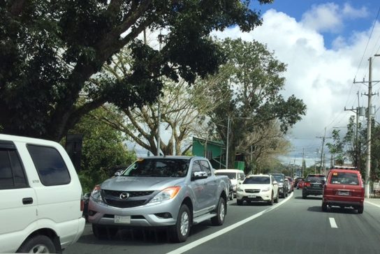
Last March 9, traffic was terrible along Marcos Highway and roads connecting to it including Imelda Avenue and Sumulong Highway due to a truck that slammed into the scaffolding of the Line 2 Extension across the Sta. Lucia Mall, and barely missing the newly constructed column supporting the girders and elevated tracks of Line 2.
 [Photo not mine but sent by an officemate who was glad to have taken his motorcycle that day instead of commuting by car.]
Following are comments I captured from Waze as I tried to get information about the traffic situation:


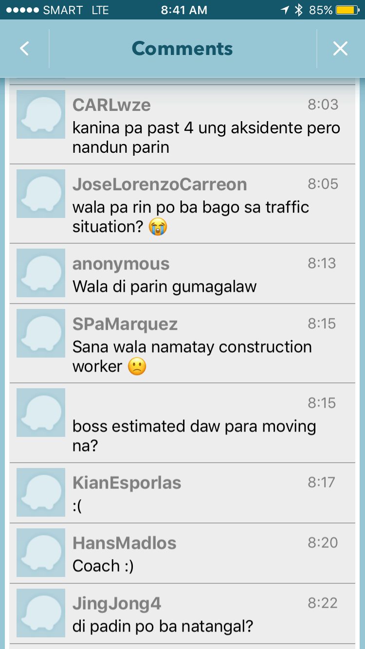

It is very clear from travelers’ comments that most were frustrated and many were angry about what seemed to be a very slow response from authorities in clearing the crash site and getting traffic to move faster. I myself wondered how a crash like this with its impacts manifesting in severe congestion along major roads was not dealt with as urgently as possible by so many entities that were not without capacity to act decisively. The front liner should have been the Metropolitan Manila Development Authority (MMDA) and there were at least four local government units directly affected by the congestion: Pasig, Marikina, Cainta and Antipolo. Surely, these LGUs could have done more if the MMDA couldn’t, in order to resolve the problem? If the availability of heavy equipment was an issue, weren’t there available equipment from Line 2 contractor, DMCI, or perhaps from the construction sites nearby (Ayala is constructing a huge mall near the area.)? Surely, they could lend a payloader or mobile crane that can remove the truck or at least help unblock the area?
I finally decided to turn back and work from home instead that day. Later, I learned that authorities had to stop traffic along Marcos Highway around 11:00 AM in order to tow the truck and clear the area for traffic to normalize. I hope this serves as a lesson in coordination among government entities and that future incidents like this will not results in a “carmaggedon” like Friday’s congestion. One thing that also became obvious is that travelers passing the area are all dependent on road-based transport and the primary reason why a lot of people were affected by the crash. The expanded operations of the Line 2, whenever that will be, will surely change transport in these areas and for the better.
–
Crowdsourcing solutions to traffic problems?
Some government agencies seems to have resorted to crowdsourcing via social media to either find or assess solutions for the worsening transport and traffic problems in Philippine cities, more specifically Metro Manila. This includes posts by the Department of Transportation (DOTr) and the Metropolitan Manila Development Authority (MMDA) about various topics ranging from public transport reform to travel demand management (TDM) schemes. From one perspective, the approach can be seen as something like a participatory approach towards finding a solution that is acceptable to most. I say so since the proposals or ideas come from what are supposed to be official accounts of these agencies and thus can be claimed as something that aims to engage the public in discourse towards finding solutions.
Following are screenshots from a public social media account and examples of the responses/comments he got for the post:


What do you think? Did MMDA do its part in analyzing or evaluating their proposal? I suspect that they did not perform an in-depth analysis despite the resources available to them. They do have technical staff and tools to do the analysis. Note that the agency acquired simulation software during the time of Bayani Fernando that they used to justify projects like the elevated U-turns at Kalayaan and the widening of Commonwealth Avenue. Their technical staff have also been training locally and abroad on transportation planning. A crowdsourcing exercise such as this seems more like a “trial and error” approach where those monitoring the responses/comments may opt instead to summarize the responses for the analyses and then determine whether to refine, push through or withdraw the proposal that was floated. I think the MMDA should do its part first (i.e., evaluate the proposal at both macro and micro levels) and then present the pros and cons of their proposal in both quantitative (e.g., improvement in travel speeds and travel times) and qualitative terms (i.e., improved productivity or quality of life for commuters).
–
Traffic congestion in Tagaytay
We got to see first-hand last weekend how terrible the traffic congestion in Tagaytay has become. Last year it was already bad but last weekend’s traffic was really awful. To be fair, not counted in the traffic jams mentioned here are roadworks (i.e., widening) currently being conducted by the DPWH along the Sta. Rosa – Tagaytay Road that have also contributed to the longer travel times to and from Tagaytay. The severe congestion is due to the intense developments in the city including high density residential and commercial developments in a city where transportation, including the road network, is not built to be able to handle the trips generated by such developments.
My brother took the following photos as we drove back to Manila:


The photos pretty much describe how congested roads are. All two lanes are full with what is basically bumper-to-bumper traffic. The last photo was taken in front of the Estancia Hotel, which is about 1.4 km from the rotonda, and the queue appears to continue well beyond this area (i.e., past Starbucks). This is a result of the traffic management at the Tagaytay rotonda where, instead of allowing vehicles to move freely (which is how rotondas are supposed to function), traffic enforcers instead stop movements from the 3 legs one at a time. The problem here is that the congestion due to the Serin mall often reaches the rotonda, and so vehicles could not proceed to exit on that leg of the intersection. This condition affects traffic from all legs and results in long queues along the Aguinaldo Highway as well as both the rotonda-bound sides of the Tagaytay-Nasugbu Highway. Vehicles cannot make left turns to Serin or the Lourdes Church because of the median barrier set-up along the highway so all have to go around the rotonda. Quite frankly, I see very little or no options in as far as solutions go. The traffic is simply too much for the roads to handle.
–
The Tagaytay transportation predicament
The title of this article is actually a bit tame and on the diplomatic side of trying to describe transportation and traffic in this city that was once relaxed a retreat for many. I had wanted to end February on a good note and so I decided to defer posting this until March.
We used to frequent Tagaytay and liked spending some rest and recreation time there to the tune of being there almost once a month at one time. Needless to say, at the time travel to Tagaytay from our home in Antipolo took us only about 2 to 2.5 hours excluding our usual stop at Paseo in Sta. Rosa, Laguna. We liked the city so much that we even considered making it a second home; even inquiring and looking at properties there.
Fast forward to the present and it has become an excruciating travel with the highways leading to the city already congested. It didn’t help that when you got there, you also had to deal with serious traffic congestion. This started not a few years ago when the city approved developments by major players including Robinsons, SM and Ayala. The developments by SM and Ayala proved to be the backbreakers with Ayala coming up with the first mall in the city and SM operating an amusement park beside its prime acquisition that is the Taal Vista Hotel. Now, there is another mall under construction by Filinvest and right at the corner of the rotonda where the Aguinaldo Highway terminates.
Vehicles queue along the Tagaytay – Nasugbu Highway towards the Rotonda where Tagaytay traffic enforcers attempt to manage traffic but appear to create more congestion instead.
More on Tagaytay soon…
–
More congestion along Ortigas Avenue Extension?
There are two malls currently under construction along Ortigas Avenue Extension – SM East Ortigas and Waltermart Taytay. Nearing completion is the SM East Ortigas, which looks like a very big mall. It is the former Ever mall beside Riverside Subdivision and close to one of DMCI Homes’ first developments. It will open on December 2 and there are already a lot of promotional tarps announcing this along major roads including C-5, Felix Avenue and, of course, Ortigas Avenue.
Waltermart is further up towards Tikling Junction. These two are actually from the same mother company SM, which has somewhat diversified its retail business so it now includes the SM malls, Savemore, Waltermart and the newly minted S-Mall. These two are sure to generate a lot of traffic and cause more congestion with the SM East Ortigas already in an area where Ortigas Ave. Extension is regularly congested. I am not aware of any studies conducted with respect to this mall but I assume there is a transport impact study somewhere. Personally, I would ask SM to look into the case of SM Novaliches for something sort of a solution to the traffic problem right in front of the mall. Quirino Highway is widest along the section where SM Novaliches is, with the mall providing a very generous setback to accommodate multiple lanes for traffic to flow smoothly at least in front of the mall. That seems possible with SM East Ortigas especially since there is practically only 2 lanes for the westbound direction of Ortigas Ave. Ext. at this area.
Waltermart is a different thing because it is in an area where there is generally no congestion along Ortigas Ave. Ext. I also assume there is a traffic study somewhere providing traffic management schemes or alleviation measures in case congestion occurs due to the mall and its high density residential development component (it is part of a complex called “The Hive”).
I am speculative about the expansive lot vacated by Mitsubishi Motors beside the Panasonic complex. I wonder if any of the big developers are acquiring it and perhaps developing it into a major mixed use project. There is also the lot where Consolidated Tobacco used to be just across Countryside Subdivision and close to SM East Ortigas. Such future developments require careful study for its transportation impacts and the Municipality of Cainta should take a proactive stance for major developments that will generate a lot of traffic. Ortigas Ave. Ext., even after some widening, remains as a road with high potential and regularity for congestion. Only a mass transit system can probably decongest it but that will take some time to realize.
–
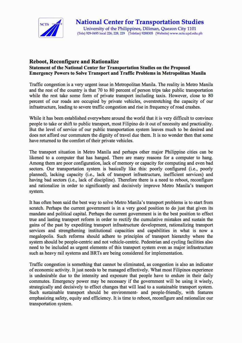
Statement on the proposed emergency powers to solve transport and traffic problems
The National Center for Transportation Studies (NCTS) of UP Diliman submitted a statement to the joint Senate committees evaluating the proposal to grant emergency powers to the Philippines President in order to solve the transport and traffic problems in the country and especially in Metro Manila. Following is a copy of the one-page statement:
–
On weather and traffic
With the onset of the wet season, heavy rains have reminded us how terrible commuting can be especially in Metro Manila where public transport services are much wanting in terms of quality. But whether you are driving or riding, using private or public transport, there is always something about the rains that make you feel uncomfortable. Metro Manila’s roads are becoming more and more notorious for flooding and I guess that goes the same with many other roads in other cities as well. Drainage is almost automatically blamed but closer inspection of the cause of flooding shows even the newest drainage systems being unable to accommodate rain waters in part due to their being clogged (by garbage, mud and/or other stuff) or having inferior design for intense rains. With extreme weather now becoming the norm, that is not a good thing especially with what is perceived as poor maintenance of our waterways and road drainage systems. Just look at how overpasses get flooded everytime the rain pours; causing traffic congestion that could have been averted if only we can weather-proof our roads to a certain extent.
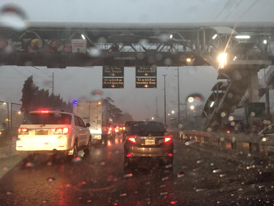
Low visibility even during the middle of the day plus slippery pavement surfaces due to heavy rains can cause congestion and lead to unsafe conditions for traveling. The latter outcome is even worse during the night and, in higher elevations, when you have fog to add to the complexity of the environment you are traveling along. Aside from travel time, nothing more serious like life or limb can be lost by practicing safe driving whenever it is raining hard. That includes slowing down, turning on your lights (for visibility) and refraining from undertaking risky maneuvers. Pedestrians and cyclists, too, need to take more caution knowing the higher risks they face or are exposed to when traveling under inclement weather conditions.
–
On cable cars as a solution to Metro Manila transportation problems
I was asked about my take on the pronouncement about cable cars being a potential solution to Metro Manila’s traffic woes. I say pronouncement because careful qualification of the news articles on this clearly show that this is not yet a proposal. I leave it to the reader to Google these articles on cable cars for Metro Manila.
The first thing that came to my mind are capacity and demand. What would be the capacity for such a system and what could be the demand given that you would have to determine where stations would be. There’s also the fear factor as many people would not be comfortable riding a vehicle so high up in the air and then of course, there’s the wind that will obviously have to be factored in the operation of such cable cars. Suitability is very much an issue here. Perhaps cable cars like the one featured in the news articles are more appropriate for cities like Baguio, Antipolo and Tagaytay? There are very limited applications for Metro Manila even including perhaps possibilities for Ortigas and perhaps Loyola Heights.
I like what my friend, Rene Santiago, said about the cable being one possible answer but not The Answer to Metro Manila’s traffic problems. I am aware of and quite amused by the comments posted on social media about the so-called ‘cable car solution’ as it is definitely not going to make a big impact on Metro Manila transport. I like comments proposing instead improved river transport as well as protected bicycle lanes around the metropolis. These are well-grounded proposals that have been proven elsewhere to be very effective in reducing congestion while mass transit projects are under construction and to be operational in 2 to 3 years time. I think it would be wiser to put your money on bike lanes and even bike bridges than in cable cars.
I was also asked about what should be the first project the new Department of Transportation Secretary Art Tugade should take on. Metro Manila is still very much a “battleground” for transport and traffic, and there are already projects lined up for implementation like the much delayed MRT 7 and the extension of LRT1. The new administration should strongly support such efforts, whether its via Public Private Partnership (PPP) or public funded. That said, I think the incoming Department of Transportation Secretary should work on an urban mass transport project in one of our major cities. Either Cebu or Davao come to mind as these cities are already also congested and would need to have an urban transit system (rail?) very soon in order to avoid becoming another Metro Manila. There are low-hanging fruits in these cities, for example, with the Cebu BRT ready to be taken on by the new administration for full implementation and Davao already being the subject of public transport studies pointing to it being ripe for a rail transit system.
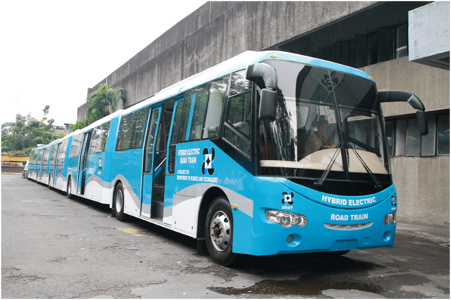
Finally, there are also the outcomes of research & development work by the Department of Science and Technology (DOST). I am referring to the DOST-MIRDC’s road train, AGT and hybrid train projects. The road trains, for example, may be used for Bus Rapid Transit (BRT) lines that are proposed for C5 and Quezon Avenue. I also think it is worth considering for EDSA. BRT is not technology-specific as far as buses go so why not use Philippine-made buses for this? While these are still subject to third party safety and technical certifications, the Transportation Department could lend a helpful hand towards this certification and this could perhaps ultimately lead to building an industry out of these buses and trains.
–
Will a flyover at Katipunan-C.P. Garcia solve the traffic problem in the area?
I read a news article about the proposal by the Department of Public Works and Highways (DPWH) to construct a left-turn flyover at the intersection of Katipunan Avenue (C5) and C.P. Garcia Avenue in Quezon City. The flyover is supposed to be for vehicles turning left from the northbound side of Katipunan to C.P. Garcia Ave., which goes through the University of the Philippines Diliman
Will the flyover solve the traffic congestion problem in the area, particularly at the intersection and Katipunan in general? I would say no, it would not solve the congestion problem both for the intersection and for Katipunan. This assessment is due to the following reasons:
- The overpass does not address the root cause of congestion in the area, which is trip generation related. There are many major trip generators along Katipunan alone including three major schools (UP, Ateneo and Miriam) and a mall (UP Town Center). Add to this the traffic generated by the high density residential developments along Katipunan (notice the high rise condominiums lining up across Ateneo and Miriam?) and the through traffic coming from various areas that use C5’s Katipunan section.
- Congestion is caused by saturated intersections corresponding to Ateneo Gate 3 and main gate of Miriam College. Traffic going in and out of these schools are favored over through traffic along C5 resulting in congestion in the area. Perhaps it would be more appropriate to build overpasses to bypass these intersections.
- Congestion is caused by vehicles bound for and coming from the UP Town Center. The congestion due to traffic generated by the commercial development is actually alarming considering it is not yet completed and trips attracted and produced is not yet at full potential.
- The heaviest flows at the Katipunan-C.P. Garcia intersection are along Katipunan (northbound and southbound through traffic). Logic and traffic engineering principles point to grade separation to be more appropriate for such traffic and NOT for the left turn movement. A flyover should also be able to bypass UP Town Center as vehicles bound for the mall already blocks traffic along both sides of Katipunan and directly affects the intersection.
I think the DPWH should do well to re-assess their proposal along the lines of the reasons I have listed here rather than continue with the folly of building a left turn overpass alone. UP Diliman should also resist this overpass as, based on the news article, it would mean UP giving up some 8,000 square meters of its property for the project. UP already has given a lot for widening C.P. Garcia but that goes without saying that a through flyover might also require UP to give up property and particularly from its National Science Complex for such a project.
–
Shopping malls and Ortigas Avenue Extension traffic congestion
Recently, I noticed that traffic has somewhat eased along the eastbound side of Ortigas Avenue Extension. For one, this was probably due to the completion of road works and the reopening of lanes between Cainta Junction and Brookside. This improved traffic flow as traffic personnel didn’t have to resort to the balancing act that is the counter-flow scheme they had been employing to alleviate congestion for mostly home-bound traffic. But a major contributor to congestion was the Ever Gotesco Mall in the former Riverside industrial complex. Malls like this are major trip generators and if traffic coming in and out of the malls are not managed properly or facilities are not provided for efficient movement of people and vehicles, then there will surely be congestion along access roads. I stated that the Ever mall ‘was’ a major contributor because the mall recently closed down and the property is now fenced off from the road. At present, there is practically zero traffic that can be attributed to the former mall.
Following are a few photos of the closed and fenced off property that was the Ever Ortigas mall.
 Jeepneys and UV Express vehicles now use the service road of the mall as a terminal.
 It’s now a breeze passing through the eastbound section of Ortigas Extension in front of the former mall. There are signs stating the property has been acquired by retail giant SM. It will probably be transformed into an SM mall.
 This driveway used to cause congestion as jeepneys and private vehicles exited the mall through this driveway and many turned left towards Ortigas westbound. These vehicle often effectively blocked traffic along the eastbound direction with queues reaching all the way past Countryside and reaching De Castro on a bad day.
There were only two shopping malls along Ortigas Avenue Extension – the Robinson’s Place near Cainta Junction and Ever Gotesco. Ever has recently close but it is expected to re-open as an SM Mall sometime in the near future. SM doesn’t have a mall in the area and the ‘nearest’ ones would be Megamall, Marikina and Taytay (not counting the Super Center beside Tiendesitas and the Super Center along Felix Avenue). If indeed an SM mall will be there soon, we could expect heavier traffic in the area given the trip generation characteristics of SM. Perhaps, though, there is an opportunity to improve traffic in the area if SM can consider some improvements to its driveways and circulation. They could probably do something like what SM Novaliches had done with their generous setback to ensure that there will be no serious congestion along Quirino Avenue due to mall-generated traffic.
SM will not be the only major commercial development that is expected to generate traffic that will lead to congestion along Ortigas Extension. Almost across the former Ever mall is a commercial development under construction with a building I think is too close to the road. Then there is also the commercial/residential project that is being constructed along the westbound side of Ortigas Extension near the Kaytikling Junction in Taytay, Rizal. I wonder if these had the necessary traffic studies to support their impacts on at least the immediate areas they will be affecting.
–
