
Highway 2000, Taytay, Rizal
Prior to taking the photos I posted on Barkadahan Bridge, I was able to take a few photos of Highway 2000.
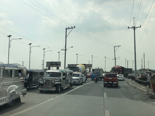
 Section right after the Taytay Public Market – it is basically a 4-lane road but there are no lane markings for either direction. There is only the double line indicating which sides are for opposing flows of traffic.
 Informal shops along the highway
 There are many garments and textile factories and depots/warehouses along Highway 2000 and from their names appear to be Chinese-Filipino or Chinese-owned businesses.
 There are also several gas stations along the highway including this Shell station that used to have cheaper fuel prices than others like it in Taytay and Antipolo.
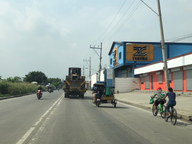 Bikers along the highway – new pavement markings should include those for bike lanes on either side of the highway. Ideally, bike lanes or bikeways should be protected and consistent with the design along C-6.
 There seems to still be a lot of informal settlers along this road as evidenced by shanties on either side of the highway.
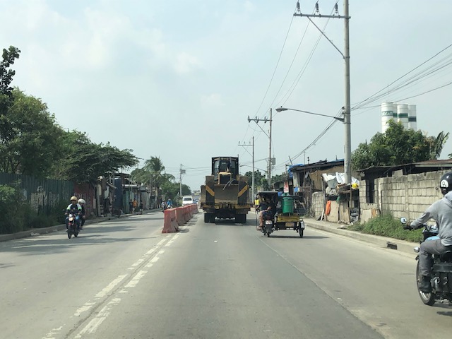
 There are many trucks using Highway 2000. Among them are those carrying tractors or heavy equipment like the one shown here hauling a bulldozer.
 Orange barriers delineate opposing traffic at the Highway 2000 approach to Barkadahan Bridge. The intersection before the bridge is with the East Bank Road of the Manggahan Floodway.
I posted the following photo earlier. This show the RROW acquired along the eastbound side of Highway 2000.

Highway 2000 already figures as a major link between Rizal and Metro Manila. It is part of an alternate route between Rizal and major CBDs like BGC and Makati via Circumferential Road 6. It is also a route to the south via Bicutan and eventually SLEX. Thus, it is imperative that this corridor and the Barkadahan Bridge be improved in order to carry the potential traffic (both non-motorized and motorized) that it is supposed to. Highway 2000 in particular should already feature protected bike lanes consistent with the design along C-6 in order for it to be transformed into part of a “bicycle highway” that can be the backbone for cycling as a mode for commuting.
–
Unraveling ridesharing/ridesourcing
I have been writing about ridesharing/ridesourcing/ridehailing for some time now. I have also researched on its characteristics particularly in my country where it was initially hailed (no pun intended) as a solution to transport woes in highly urbanized areas. We’ve done our research with or without the cooperation of these companies. It does not surprise me that their operations have unraveled and many are exposed to be abusive. So much for being the ‘disruptive’ initiative that was praised by many before…
Emerson, S. (2019) “Uber Drivers Protest ‘Corporate Greed’ as Billionaires Cash In”, https://onezero.medium.com/uber-drivers-protest-corporate-greed-as-billionaires-cash-in-df65a7e470a7 [Last accessed: 11/18/2019]
–
Traffic congestion due to Barkadahan Bridge rehab
Here are more photos of the situation in the vicinity of Barkadahan Bridge. Photos were taken on a late Sunday morning (around 11 AM). Photos show the traffic congestion particularly along the eastbound side of Ejercito Avenue and Barkadahan Bridge.
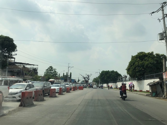 Even before completely crossing the bridge, one can see how long the queue from C-6 is. This is a photo of the queue just past the West Bank Road. The road here is names Ejercito Avenue after former Pres. Joseph Estrada whose real family name is Ejercito.
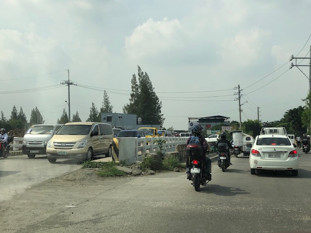
 Truck occupying an entire lane and encroaching on one of the lanes to C-6. This is due to the bottleneck caused by the wall of a residential subdivision across from the Greenwoods gate. The wall actually only contains the subdivision name and yet DPWH has been unable to expropriate the land that includes part of that subdivision’s driveway.
 Long queue extending towards Tapayan Bridge along Ejercito Avenue
 Queue along Tapayan Bridge or bridges considering there are two – one for each direction of traffic.
 Queue crossing the bridge and the bend towards C-6 and Lupang Arenda, which is a major relocation site for Metro Manila squatters during the time of then Pres. Joseph Estrada. Vehicles turn left towards C-6 while those going straight continue along Ejercito Avenue towards Pinagbuhatan, Pasig City.
 The queue reaches C-6 on a Sunday morning. It is likely worse on weekdays.
–
Sri Lanka Airport Departure – Part 1
Before I forget, I am posting the following photos of Bandaranaike International Airport when we departed for home last September.
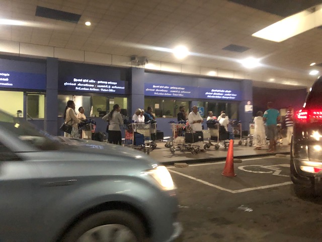 Arriving at the airport terminal driveway – it was quite early in the morning and we didn’t expect to see so many passengers
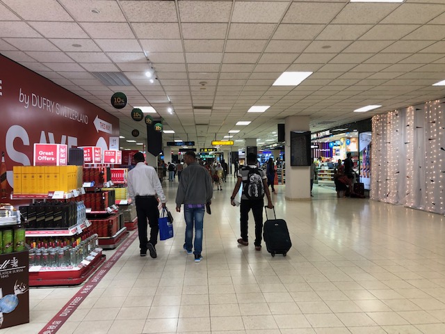
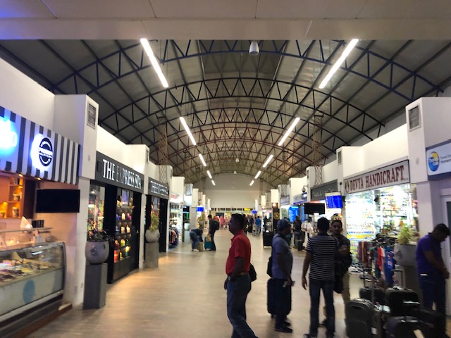 Entering the terminal, you are greeted by rows of shops selling a variety of items mostly souvenirs and foods and tea
 Souvenir items include clothing, tea, and electronics
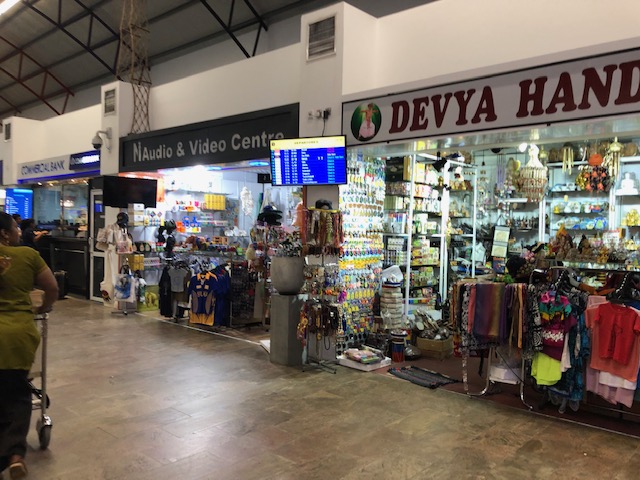
 Local products including handicrafts. I bought a mask and ref magnets at one of the shops.
 The terminal has many empty spaces. I guess they still do not have so many visitors to necessitate more commerce?
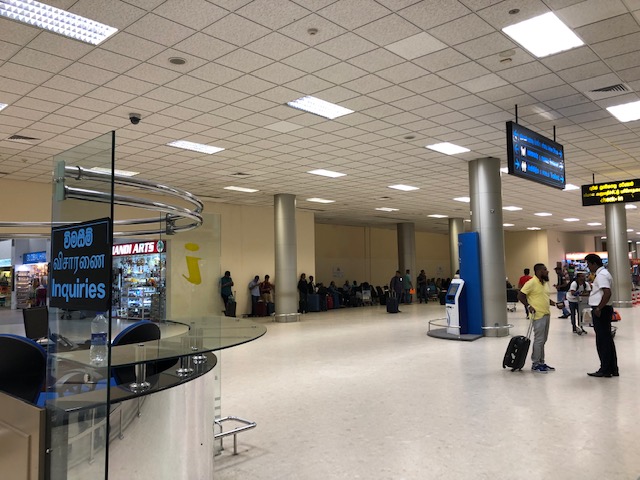 The area just before the check-in counters is spacious. We wondered if the terminal can be quite crowded during the day.
 Check-in counters for Sri Lankan Airlines – there were a lot of visitors from Arab countries due to an international Islamic convention in Colombo. Many of them were catching the earlier flights out of the country that day.
 Check-in counter for our flight
 After checking-in, we immediately entered the pre-departure area. Large screens show flight schedules and there were signs towards the gates.
 An escalator leads to the pre-departure area where there are more shops and restaurants
 Of course, there were many shops selling teas but there were also many local products like these leather stools that also doubles as storage. These are collapsible and can easily be packed for travel. A friend brought home one for his home.
 Jewelry store at the terminal – Sri Lanka is the source for many of the world’s gemstones. Of course, the prices are very competitive and one should probably go to legitimate stores in the city instead of buying at the airport.
 Liquor and cigarettes are popular items
 More tea shops along with cosmetics and perfumes at the duty free stores
 The area between the shops and the corridor towards the boarding gates
More photos soon!
–
Sabit
A common sight along Philippine roads are overloaded public utility vehicles. It may be indicative of how difficult it is to get a ride because such is usually the case when there is a lack of public transport vehicles during peak periods (i.e., when transport demand is greater than the supply of vehicles). That lack maybe due to simply not enough vehicles to address the demand or that there is enough on paper and operating but they are not able to make the return trips fast enough. The first case means demand has grown but the number and capacity of vehicles have not kept pace with the demand. The second means that technically there are enough vehicles (franchises) but the traffic conditions along the route have worsened and has resulted in vehicles not being able to travel fast enough to cover the demand.
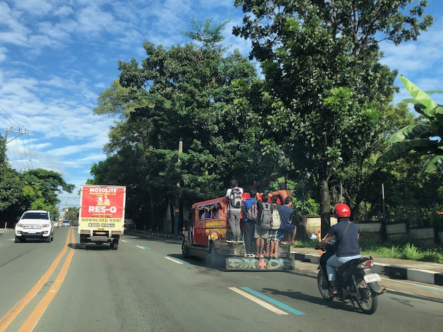 Jeepney with 6 passengers hanging by the back. All look like they are laborers or workers (construction?) but it is not uncommon to see students in their school uniform similarly dangling from jeepneys especially during the peak hours when its difficulty to get a ride.
Sabit is actually illegal and, if enforcers are strict, will incur apprehension and a ticket. Many local enforcers including those of the MMDA though are lax about this especially during peak periods. Jeepney drivers are more cautious when they know that Land Transportation Office (LTO) enforcement units are on watch as these are usually strict about passengers dangling from the vehicles. Newer jeepney/jitney models basically eliminated sabit as the doors are now on the right side of the jeepney instead of the back and there are no spaces or features to hold and step on to in the new models. It is for good as this is an unsafe situation for the passengers and there are reckless jeepney drivers who tend to exacerbate the situation by deliberately maneuvering the jeepney as if he wants passengers to fall off the vehicle. To those looking for a thrill (or death wish as a friend calls it), it is an exhilarating experience. But in most cases, it is a disaster waiting to happen.
–
Status of Barkadahan Bridge, Taytay, Rizal
I recently wrote about the Barkadahan Bridge and its current state and compared it to the Marcos Highway Bridge that is now completed and fully opened to travelers. Unfortunately, I didn’t have photos to share but only shared my observations based on what friends have told me and what I’ve read on social media (i.e., Rizal Provincial’s and Taytay’s official Facebook pages) about the situation there. I finally had the opportunity last Sunday when I went to fetch my family at the airport. Here are photos of the Barkadahan Bride and its environs. Note that Barkadahan is actually two bridges and not one. The new one is currently being used for two way traffic (one lane each) while the second one is under rehabilitation and retrofitting. The latter had and will have 2 lanes, too.
 Approach to the Barkadahan Bridge via Highway 2000 – notice the widening on the south side of the highway? That’s the ROW expropriated to align the bridge(s) with the highway. Ultimately, this should be of the same width as C-6.
 Closer to the bridge, you see more of the ROW acquired to improve the geometry for the area and the intersection with the East Bank Road. Highway 2000 is now aligned with the second (newer) bridge constructed that will eventually carry only the eastbound traffic. The older bridge currently being rehabilitated and retrofitted will carry the westbound traffic.
 Vehicles crowd on the two-lane bridge that is the new Barkadahan Bridge. The old one is currently being rehabbed. Notice the significant volume of trucks using the bridge? This is expected to increase due to the industrial developments in Rizal Province and along C-6, and the direct route this corridor provides towards the SLEX via Bicutan.
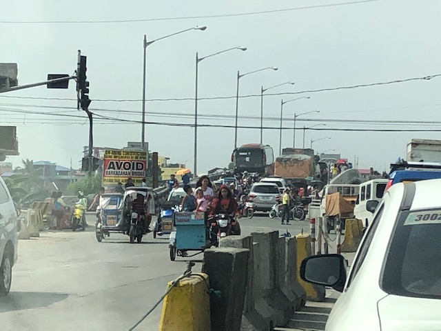
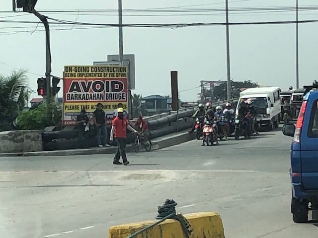 Big sign at the bridge – there are many of these scattered around Pasig and Rizal advising travelers against using the route and Barkadahan Bridge because for the construction work on the bridge. This ‘avoidance’ basically transferred (some say returned) much of the traffic to Ortigas Avenue Extension. Many if not most users of the bridge use this alternate route to travel from Rizal to BGC and Makati CBD.
 A peek at the construction work on the old bridge – note that the contractor seems to have completed installing the steel reinforcement for the slabs for this section of the bridge. The next phase would be the concrete pouring.
 Still another peek showing the extent of the work on the old bridge – my casual observation of the work areas was that there seems to be not so many workers. But then maybe it was a Sunday? Perhaps there should be more people working considering this is a very urgent project?
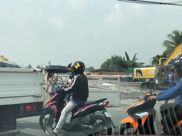
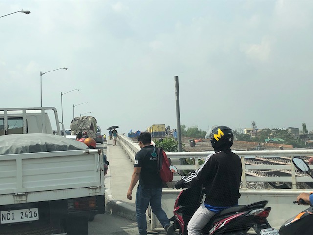
 Tricycles, motorcycles and bicycles – there’s a lot of local traffic using the bridge and these are represented by mostly tricycles serving the residential and commercial areas along the East and West Bank Roads and the cyclists you most often see crossing the bridge. Most motorcycles are through traffic. On weekends one can observe more recreational cyclists as this route is a popular one to Rizal and particularly its mountainous areas that are popular to mountain and road cyclists.
 Counterflow – many motorcyclists tend to counterflow and this adds to the friction and slows down traffic. Once the other bridge is completed and re-opened, these will likely be reduced to lane splitting or filtering as the opposite flows of traffic will be assigned to separate bridges. Counterflow traffic will then be very obvious and should be apprehended.
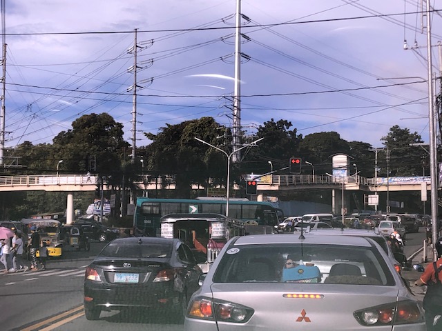
 Here’s the resulting queue on the other side of the bridge. This is severe congestion that reaches C-6. Note that the photo was taken on a Sunday. Perhaps these travelers have no other option but to use this route so they are stuck in hellish traffic on a Sunday? I can only imagine how worse it is on weekdays.
As a parting shot, I think there are still a couple of things that need to be addressed once the bridges are both open to traffic:
- Optimizing traffic management at the intersections with the East Bank Road and West Bank Road of Manggahan Floodway – the (mis)management of traffic here also contributes to congestion in the area. Traffic enforcers on both ends of the bridge have basic knowledge of how traffic must be managed and end up with the “buhos” approach. They don’t seem to be coordinating with each other, too. Their approach also heavily favors the East and West Bank roads when traffic is heavier along the main corridor that is C-6/Highway 2000. There needs to be a more efficient way to manage traffic here and that may be in the form of a sophisticated traffic signal system at least for the two intersections. Settings need to be studied and signals have to be adaptive to the variation of traffic throughout the day.
- Resolve bottlenecks in the area including structures that tend to reduce capacities of the approaches to the bridge.
More on this topic soon!
–
On the importance of trees in the urban setting
Having lived in two other countries and traveled in many others, I have seen and experienced for myself examples of tree lined avenues and streets in the urban setting. And I am not talking about small cities but big ones like Tokyo and Singapore. I have gone to many of the big cities in Japan to be able to say that trees should have their place in the so-called urban jungle and the benefits of having them are tremendous. Here is a nice article recently published in The Guardian that explains the advantages of green streets:
Balch, O. (2019) “Green streets: which city has the most streets?”, The Guardian, https://www.theguardian.com/cities/2019/nov/05/green-streets-which-city-has-the-most-trees [Last accessed: 11/08/2019]
Philippine cities should heed the advice from the author and city and municipal planners should make sure that plans incorporate trees and other flora. Obviously, they are not just ornamental but rather should be indispensable components of our towns whether it is highly urbanized or not. I guess the same concepts apply also to the roadsides of our national highways. The Department of Public Works and Highways (DPWH) clearly had little or no regard for greenery; chopping down even the elder trees along the way of their road widening programs. As such, they have contributed to blight along these roads and it would take some time and effort to bring back what used to be tree-lined, canopied roads in many provinces.
–
On Tikling Junction traffic (mis)management
There was an uproar among commuters when Taytay installed traffic signals at the rotunda at Tikling Junction. The junction is the intersection of Ortigas Avenue Extension, which continues towards Antipolo, the Manila East Road, which connects many of Rizal Province’s towns, and Leonard Wood Road, which leads mainly to residential areas in Taytay. There is another road that is close to the junction, Cabrera Road, that qualifies the intersection to be an offset type. However, vehicle coming in and out of Cabrera Road mainly are with respect to the Manila East Road.
 Traffic signals as seen from the Manila East Road approach to the rotunda
 Traffic signals as seen from the Ortigas Ave. Ext. leg approach from Antipolo
The horrendous congestion last Thursday was due to the settings of the signals that forced most vehicles to stop even though there were movements that were not in direct conflict with others (e.g., through traffic along Ortigas Ave. Ext. from Antipolo towards the direction of Valley Golf/Cainta and right turning traffic from Ortigas Ave. Ext. to Manila East Road). The results were vehicles backed up all the way to Cainta Junction along Ortigas Avenue Extension and SM Taytay along the Manila East Road. We were able to experience the slight congestion the following day (Nov. 1) when we descended to Tikling from Antipolo. Congestion was slight probably because of the significantly reduced traffic due to the holidays.
I thought, based on experiences at this junction, that the traffic signal settings somewhat mimicked the style applied by Taytay traffic enforcers when they manually manage traffic at the intersection. Too often, they apply the “buhos” system where they try to let through all vehicles they see queued per approach. The outcome of this, of course, is longer stopped times to all other vehicles from the other legs resulting in longer and longer queues that become unmanageable especially during the peak hours (i.e., when vehicle arrivals are highest at the intersection). Basically, what happened last October 31 was that the “buhos” traffic enforcers were replaced by the machines (i.e., traffic signals) that employed the same system only this time there was no opportunity for some flexibility for movements that had none or the least conflicts at the intersection.
–
Modified jeepneys?
I spotted this modified jeepney along my commute between Antipolo and Quezon City. The jeepney has been modified so its door is no longer at the back like most jeepneys but at the right side. Judging from the design and the license plate, this was not a “new” jeepney though its the first time I saw this along my regular commute.
 Modified jeepney plying the Antipolo-Cubao (via Sumulong Highway) route
The design is a safer one as passengers board and alight from the right side and to the sidewalk (assuming the jeepney driver positions the vehicle in the right manner for a stop). A back door meant passengers boarded and alighted in front of another vehicle or is exposed to traffic. This reminded me also about the designs for LPG jeepney models that were rolled out more than a decade ago but didn’t really take off. The electric jeepneys also have models with the side door that is now found in most models including non-electrics in the modernization program. Perhaps the government should require all jeepneys to be at least retrofitted this way?
–
Cooperative work among LGUs to address transport problems along Ortigas Avenue Extension?
I saw a recent post about a meeting hosted by Pasig City. The Mayor of Pasig City recently held a meeting where he invited the mayors or Antipolo, Cainta and Taytay to discuss, among other things perhaps, transportation along Ortigas Avenue. Ortigas Avenue is a corridor shared by several LGUs most notably the Rizal towns of Antipolo (which is the provincial capital and a highly urbanized city), Cainta and Taytay. The latter two are among the richest municipalities in the country; a fact I underline here since that also should translate to them having the resources or means to help come up with transport and traffic solutions.
 Morning rush traffic starts very early these days. This photo was taken around 6AM on a Thursday along the westbound direction just after the Manggahan Bridge. The pedestrian overpass at C. Raymundo junction is shown and the dark colored buildings are at Robinsons’ Bridgetown development. Note the commuters along the right waiting for a ride.
Photos paint a thousand words. The Taytay Mayor attended the meeting. He has been under fire for the horrendous traffic caused by the mismanagement of Tikling Junction as well as the Barkadahan Bridge area that was and is supposed to be a major alternative route for Rizalenos heading to their workplaces in Makati and BGC. More recently, there were posts about the traffic signals installed at Tikling Junction that basically invalidates the roundabout concept for the junction. The result last Thursday, the first day of operations for the signals, was hellish traffic that backed up a couple of kilometers along the Manila East Road and Ortigas Ave. Extension (some reports say until Cainta Junction). This, even as the signal settings were supposedly done with help from the MMDA.
Antipolo was represented by its former Mayor and husband to the current one. He also happens to be a former Governor of the Rizal Province and likely to run again as his mother, the current governor, is on her 3rd term. It seems to me that the province is not so interested in solutions for Ortigas Avenue despite most of its constituents traveling through the corridor to get to their workplaces and schools. Marcos Highway is not the main corridor for Rizal towns as it basically carries only Antipolo and maybe some of Tanay (via Sampaloc) traffic. Ortigas Avenue Extension branches into two major roads from Tikling – Ortigas Ave Extension, which ends at the capitol, and the Manila East Road, which connects to practically all of Rizal towns with San Mateo and Rodriguez (Montalban) being the exceptions. It is time for the province to pay attention to this commuting problem experienced daily by her constituents.
The Mayor of Cainta seems not as interested as the others, sending a representative who appears to be not one of the top officials (the traffic chief with a rank of SPO1=Master Sergeant is lower ranked than a councilor) of the Municipality to such an important meeting. In fact, he is currently now embroiled in a controversial faux pas involving himself by not wearing a helmet while riding a motorcycle. What’s more is his downplaying this and appearing to be even justifying the act. He eventually apologized but not before stating his moves. He is not new to publicity (stunts?) and knows how bad publicity still translates to good publicity especially in this days of fake news and trolls (he apparently has many on social media). He seems to forget that transport and traffic solutions for Ortigas Ave will likely benefit anyone seeking reelection or higher office in Rizal. He is on his last term as mayor and the break-up with some of his allies including his former Vice Mayor who ran against him in the last elections shows the limits of his political career. What was rumored as plans to run for Rizal governor might just be downgraded to perhaps Vice Mayor? In any case, he should show more interest and effort in finding solutions beyond traffic management and not by himself but in cooperation with others with whom his jurisdiction shares the problems with. Perhaps the initiative of the Pasig Mayor presents an opportunity for such cooperative work? Many people are very interested in this and will be watching – and hoping.
–
