
On the PUV modernisation program – Part 1
Much has been written about the government’s PUV (or jeepney?) modernization program so I wouldn’t really be reposting about these. Instead, I will be featuring some opinions, insights and observations about its implementation.
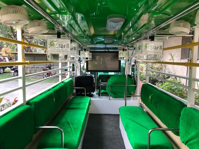
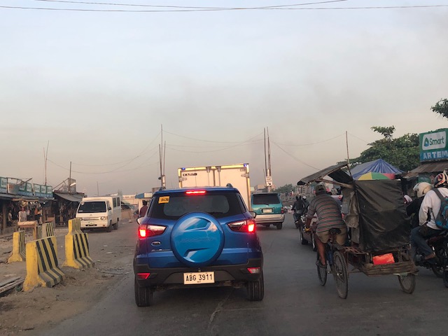
Following are photos of one e-jeepney model that the government appears to be promoting. This is the e-jeepney produced by Star8 that they claim to be have solar panels for charging while they are on the road. Of course, we know they are not wholly dependent on solar power and have to be charged the conventional way through an adaptor that’s plugged into a regular outlet. These e-jeepneys were supposed to supplement the reduced supply of public transport to mainly UP students, staff and faculty members when the i-ACT (Inter-Agency Committee on Traffic) conducted their “Tanggal Bulok, Tanggal Usok” campaign in the UP Diliman area. First-hand reports revealed otherwise as the e-jeepneys spent more time on stand-by and just charging at one of the buildings on campus.


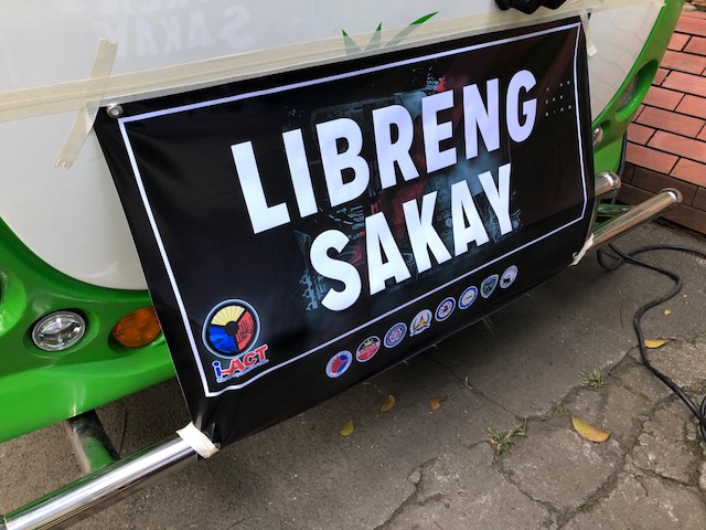
These are the same e-jeepneys that have been deployed and currently roaming around Tacloban City (promoting themselves?). The intent was for these to be the vehicles plying the new routes approved by the LTFRB/DOTr, which they claim was in response to the request made by Tacloban. The new routes though overlapped with many existing jeepney routes, clearly in violation of the general rule regarding overlapping routes, but allowed nonetheless by the regulating authority.
There are many allegations going around about e-jeepneys being forced upon operators and drivers given what has been regarded by progressive groups as unrealistic (read: unaffordable) financing schemes for the new vehicles. These are certainly not cheap, and double to triple the price of a ‘newer’ conventional jeepney. There are also suspicions about the strong motivation for the phaseout in favour of what are peddled as the successor (or replacement) to the jeepney. That includes a possible collusion among officials and the companies behind these vehicles and allegations (again) of some people likely gaining financially from the set-up. The DOTr and LTFRB PR machine, however, deny this and will gang up on anyone posting about this in their social media page.
–
On the Pasig HOV traffic experiment
Someone shared a post about a traffic scheme they will be implementing along Julia Vargas Avenue in Pasig City. The proposal is for the avenue to have a high occupancy vehicle (HOV) lane where vehicles with 4 or more occupants are to take one lane and all other vehicles the other. I am not entirely sure about the objective other than to promote high occupancies for vehicles. However, it would be nice to see how travellers will be behaving (e.g., complying) and how Pasig (with MMDA?) will be enforcing this scheme.
This is what a segment of Julia Vargas currently looks like with 2 wide lanes designated for motor vehicles (separated by the solid yellow line) and one narrow lane for cyclists (adjacent to the shoulder):
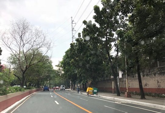
The intent is good but as a major link the scheme can be quite confusing especially for those who are not necessarily frequent users of this road. I assumed the yellow line was painted by the DPWH but it seems it was by Pasig. Perhaps they should have removed the old markings? Or maybe better if they rationalised the carriageway width to accommodate 3 lanes for motor vehicles and 1 wider lane for bicycles? From the photo above, it appears to me that it is possible to have 2 narrow lanes for general traffic and one wider lane for HOVs (in this case defined as having 4 or more occupants) and public utility vehicles. This configuration maximises the capacity of the road while having a the “best” lanes allocated for HOVs and bicycles.
I wish them success on this social experiment. Perhaps there can be valuable learnings from this including the need for connectivity to other links as well.
–
Airport airside congestion in London
My wife sent me this photo prior to taking off from London Heathrow on her way home.
 That’s a very long queue of planes waiting to take off!
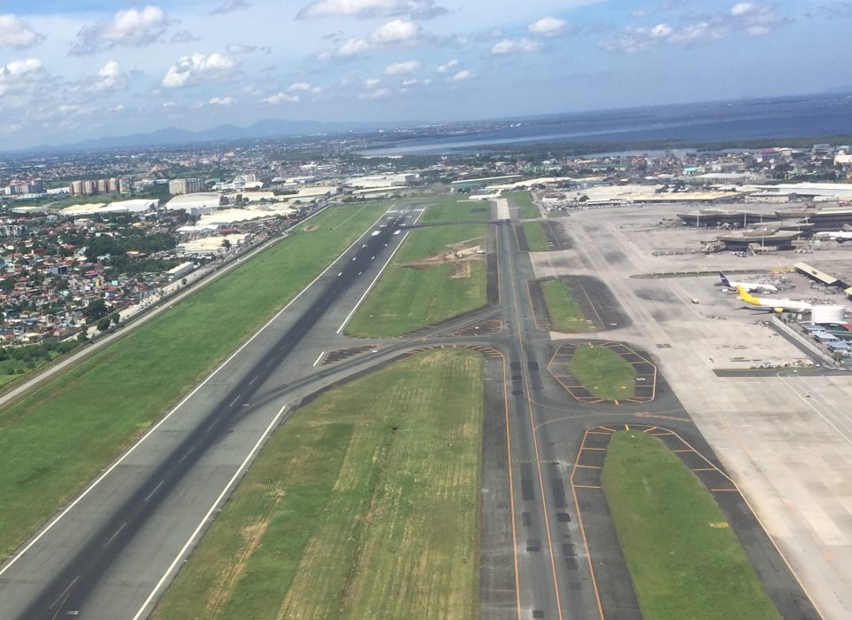
This reminded me of the articles that came out about a multi-billion peso plan to expand the Ninoy Aquino International Airport with a giant terminal forming out of connecting Terminals 1, 2 and 4. Even with a huge terminal building with a much higher passenger capacity, NAIA still would’t be able to solve its congestion woes with only 2 (intersecting) runways. Take it from the capital city airports in the region including Singapore’s Changi that has multiple parallel runways that allow for almost simultaneous take-offs and landings. Such allows the airport to handle more flights – plain and simple.
–
On riding bicycles slowly
I saw this interesting article on cycling/biking that I thought was quite relevant to the situation we have on campus. The University of the Philippines Diliman campus has a bike lane along the inner side of its Academic Oval that has been used by various cyclist types. There are those who use their bikes for commuting or going around campus (e.g., students traveling between buildings for their classes, messengers bringing documents, etc.). There are those biking in a more relaxed manner (i.e., for recreation). And then there are those who bike for fitness including those racing around the oval. It is from the latter that UP Diliman has received complaints about conflicts with joggers, motor vehicles and fellow cyclists. But then UP has maintained that the bike lane is not for racing or taking laps around the oval. It was created to have a segregated (and in the future maybe protected) lane to enhance mobility more than any other purpose.
Babin, T. (2018) “How to ride a bike slowly (and why you would want to),” Medium.com, https://medium.com/shifter/how-to-ride-a-bike-slowly-and-why-you-would-want-to-b544ec869846 [Last accessed: 2/4/2018].
 UP Diliman’s Academic Oval now features a bike lane between a jogging/walking lane and the lanes assigned for motorised traffic. The ice cream vendor on a NMT 3-wheeler is running on the bike lane.
–
On old maps
I have a fascination for old maps. These include the stylised ones and even those that are considered mythical like the Piri Reis map. Here is something that’s real and old that the map enthusiasts among my readers maybe interested in:
You can download versions of the map though the good ones are quite big and slow to obtain if your internet connection’s not good.
–
On the future of city streets
Here is another article, this time on the future of city streets. I had been sharing many of the ideas related in the article in the Transportation Engineering courses that I handle including those pertaining to the Complete Streets concept and road diets. The article is good reading material for my students who need to get out of the box (so to speak) of traditional civil engineering thinking regarding highways and streets. That is, we need to do more people-centred rather than car-centric designs.
Davidson, J. (2018) “What Is a City Street? And What Will It Become?”. New York Magazine. http://nymag.com/daily/intelligencer/2018/01/what-is-a-city-street-and-what-will-it-become.html [Last accessed: 2/2/2018].
Here is a photo I took in Iloilo City a couple of years ago showing the bikeway along the Diversion Road. The facility then was underutilized but was supposed to represent, along with the Promenade along the river and the redevelopment of the old airport site in Mandurriao, the revitalisation of the city. Meanwhile, there have been little done for the downtown streets.

Iloilo City provides a good example of the need to have a more holistic transformation rather than have some exhibition or demonstration pieces for inclusive transport here and there.
–
On parking issues
I am sharing this article on parking issues written by an acquaintance:
Litman, T. (2018) “Fun Parking Facts,” Planetizen.com, https://www.planetizen.com/node/96957?utm_source=newswire&utm_medium=email&utm_campaign=news-01292018&mc_cid=9256109649&mc_eid=9ccfe464b1 [Last accessed 1/31/2018].
Todd talks about parking in general and then goes into the details of issues including the costs of parking and how the allocation of land to provide for parking spaces has practically robbed us of more efficient and valuable use of such spaces. Of course, the article is about the experiences in the US and Canada but the issues are very much relevant to highly urbanised cities in the Philippines as well. Then, there are also the deficiencies of our National Building Code and its implementation, as well as local governments issuing ordinances or executive orders that may or may not improve the parking situation in their constituencies. How is parking in your area?
–
Congestion along C-6 and potential for a public transit corridor
We begin February with a post on a road that’s becoming more popular as a major (as opposed to alternate) route to Bonifacio Global City (BGC) and Makati CBD – Circumferential Road 6. I took the following photo at the approach to the Nagpayong Bridge that is current has only 2 lanes (1 per direction). Another bridge is being constructed along the existing one that will increase capacity for the Pasig River crossing to 2 lanes per direction. This is similar to what was done to the Barkadahan Bridge crossing the Manggahan Floodway in Taytay, Rizal.
The volume of road vehicle traffic is steadily increasing along C-6. The adjacent land use offers a lot of potential for development (hopefully planned) that will feed more traffic along what will become a major thoroughfare in the near future. The land I am referring to are the reclamations on the side of Laguna de Bai along C-6 that are under the jurisdiction of Taguig and similar developments on the opposite side on what was once swampy or marshlands. One wonders if Taguig has a plan for all this or if the city is turning a blind eye and just letting developers do what they want. Most seem to be residential subdivisions and industries-related with a sprinkling of mainly small to medium-sized commercial developments.
Again, I think national and local governments should consider making this a public transport corridor by introducing formal public transport in the form of a scheduled bus service stretching from, say, Bicutan Interchange to Taytay Public Market. The demand along this corridor is steadily rising and only a better connection to C-5 limits an even steeper increase in traffic volume along C-6. The time is now in order to condition commuters about the system and to the unwanted congestion experienced along major roads in the metropolis.
–
On airport runway names
There’s an interesting article on runway renaming that appeared on Wired. Ever wondered what those numbers on airport runways are about? Well, they represent the runway’s orientation, which is influenced by many factors among them the magnitude and dominant directions of winds. Historical wind data are collected and translated into a wind rose, which looks very much like a compass, and is used to determine a suitable orientation for a runway.
Davies, A. (2018) Thank the planet’s shifty magnetic poles for runway renaming, http://www.wired.com, https://www.wired.com/story/airports-rename-runways-magnetic-shift/?CNDID=37243643&mbid=nl_011918_daily_list3_p2 [Last accessed 1/21/2018].
 NAIA’s main runway is 06-24 or 24-06 depending on the take-off or landing direction. Does it need renaming, too?
–
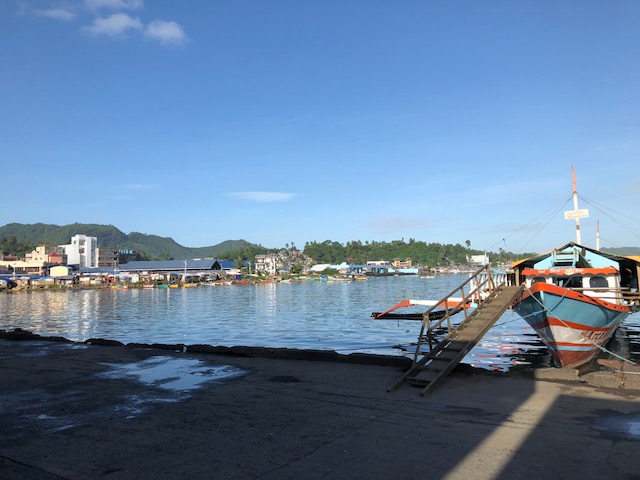
Tacloban City waterfront
While going around the city’s downtown area last week to inspect the work of our surveyors, we decided to take a break at a fast-food restaurant near the port. This branch of the fast-food chain offered nice views of the city’s waterfront and I took a few photos that I share below:
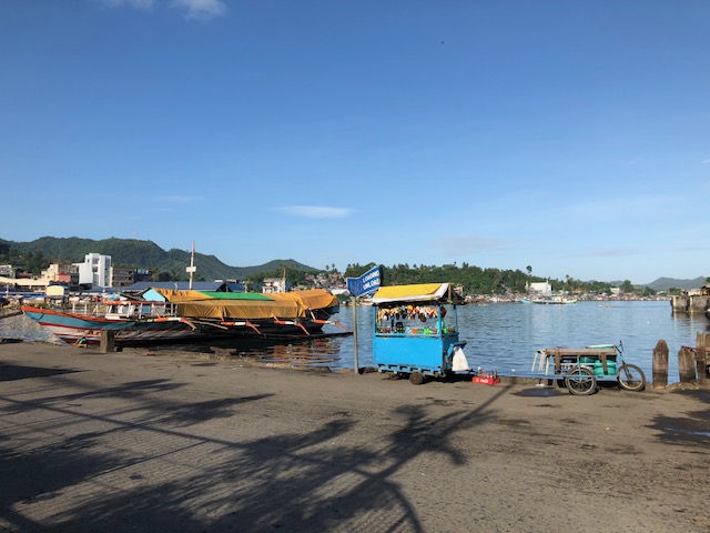 A vendor’s cart located at the road behind the fast-food restaurant – the road is used by public utility vehicles as an informal terminal and you will seldom see vehicles passing through it.
 A large outrigger sits at the port. These vessels
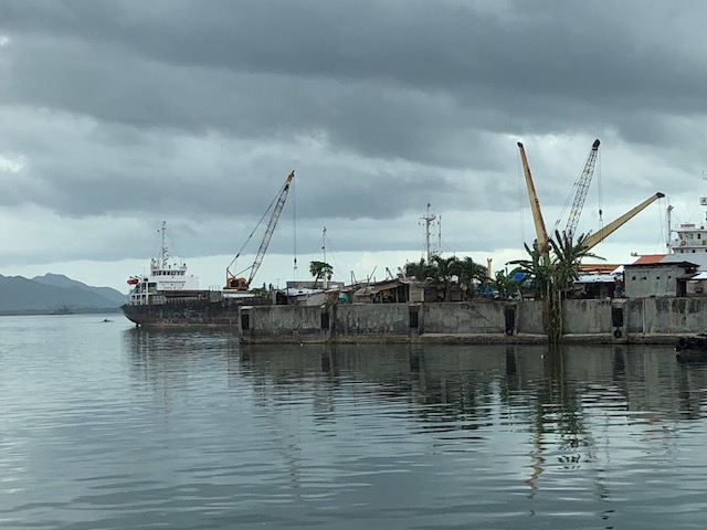 Freighters and cranes at Tacloban’s port
 A ship arriving at Tacloban
–
