
Home » Posts tagged 'Marikina' (Page 2)
Tag Archives: Marikina
Shoes made in Marikina
This seems to be an odd topic for this blog at first but then shoes are very much related to transportation. You have to have a good pair of shoes on you for walking, jogging or running. There are even driving shoes and boat shoes (i.e., those docksides and topsiders were originally made for boating or walking along the seaside). And so I write this short article about shoes; particularly those made in Marikina.
Marikina is well-known for its shoemaking industry. It used to be a major industry that manufactured shoes that were popular throughout the country as well as being exported for sale abroad. These were mainly handmade using techniques and skills passed on from one generation to the next. It was not uncommon for families to be involved in shoemaking and the brands of many shoes carry the names (or combinations) of families involved in the business. There was even a Marikina Shoe Expo in Cubao where I recall we had bought many pairs of shoes for school and casual days. Among the brands I remember were Chancellor, Valentino and Cardams. There is also a Shoe Avenue in the city along which many shops are located. In many cases, these are also the factories themselves.
The industry suffered due to a combination of automation (i.e., mass production) and the influx of cheap shoes from China. Without government support for the industry, many, regardless of whether they were small or big, eventually seized shoemaking. Those who survived and those who were revived are the ones you still see. And then there are upstarts who have been encouraged by the support now being provided by the city government. One venue for this support is through a “Sapatos Festival” that the city organises to promote shoes and other footwear made in Marikina.
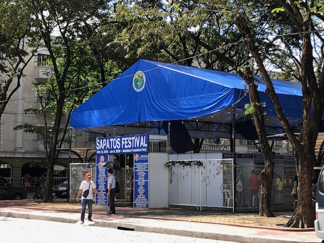 The Sapatos Festival was held right across from the Marikina City Hall.
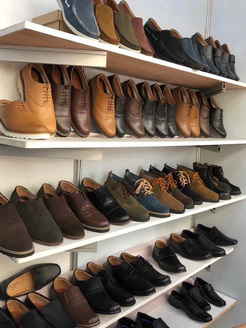 One could find a variety of footwear using various materials including genuine leather, rubber, faux leather, etc. This photo shows men’s shoes being sold at one of the shops there.
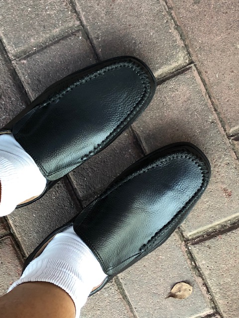 I tried on a pair I fancied and after the typical examination of workmanship and quality, I decided to buy this pair for 900 pesos (about 9 US dollars!).
Marikina-made footwear and bags are also sold at the Riverbanks mall that used to be a textile factory complex. These are inexpensive yet very good quality products that I think we should re-discover and support. Perhaps we should also provide constructive comments or suggestions on how the makers can further improve their products in order for them to be able to compete with the mass-produced variety. There is definitely a market for well-made footwear whether you walk, take public transport or drive.
–
The ill-located terminal at Ligaya along Marcos Highway
There is a newly constructed public transport terminal in what is popularly known as the Ligaya area along Marcos Highway in Pasig City. The terminal is right across from the new Ayala Feliz Mall. The terminal is mostly unused or under-utilised. The jeepneys and UV Express vehicles that were supposed to use the terminal seldom go there as the natural stop for most coming from Pasig to Marikina would be closer to the junction of Marcos Highway with Amang Rodriguez Avenue. There is also the U-turn slot nearby where many passengers dare to cross to in order to catch a ride. Sinasalubong ng mga tao ang jeepney na lumiliko dito and the traffic enforcers in the area generally turn a blind eye to this.
 The practically empty terminal during evenings
Late at night, the terminal is dark with the lights turned off. Most times I pass by the area in the mornings and afternoons, there are few, if any, PUVs at the terminal and you don’t see a congregation of a lot of passengers there as with other terminals. Did Ayala make a mistake with this terminal? For one, it is known already that while this area is a transfer point for many passengers, the location of the terminal with respect to the established U-turn slots make it unsuitable and undesirable for most PUVs. Then there is the impending operations of the Line 2 Extension whose nearest station will be hundreds of meters away across Robinsons Metro East and Sta. Lucia Mall. I think Ayala needs to construct a physical connection to the terminal if only to increase the number of people going there and therefore attract PUVs. Finally, the area is not a terminus (or last stop) for PUVs so it doesn’t make sense for them to spend time there except perhaps during off-peak periods (i.e., for rest). However, it is not attractive even for the latter since there seems to be no amenities including stores or maintenance shops to support PUVs.
–
Park and ride near the Line 2 Santolan Station?
These days when there are heavy rains and the threat of flooding, the Marikina river and its riverbanks come to mind. In the Santolan area, where a former Mayor of Marikina has invested a lot in developing a bus terminal, he seems to be stretching it in terms of trying to make the area a major intermodal terminal and maximising utility of the land. The latest venture is described by the sign below:
 “Park and ride” sign along the Marcos Highway Bridge crossing the Marikina River
A closer look at the sign shows what’s written at the lower part. That is, that the parking spaces are “walking distance” from the Line 2 Santolan Station. I’m not sure if they measured the actual walking distance and what it would take to walk that distance between this parking area for the “park and ride” and the Line 2 Santolan Station. A quick measurement using Google Maps indicate that the distance between these two are more than 400m, and this is not an ‘easy’ walk considering that you would have to ascend from or descend to the riverbanks level and there is no shelter from the elements for what would be regular walks if one is to commit to this “park and ride” arrangement. If I were to walk such a distance, then I would likely choose to park at the mall and use the long footbridge connecting it to the station.
I still maintain that the best location for a “park and ride” would be one near the station similar to the Trinoma mall parking lot being practically adjacent to the Line 3 North EDSA station. And that is what LGUs, the railway authorities or the private sector should look into for projects like the Line 2 Extension and Line 7. The area around the future Line 2 Masinag Station presents a lot of possibilities in terms of parking facilities including perhaps a redevelopment of the existing SM City Masinag to be integrated with the station. As for Line 7, the areas around another SM City (Fairview) also presents opportunities for “park and ride” facilities.
–
Some updates on the Line 2 Extension
I just wanted to post a couple of photos showing the progress of the Line 2 Extension construction work. There are two stations along the extension including the future end station before the Masinag Junction (intersection of Marcos Highway and Sumulong Highway).
 Ongoing construction of the Line 2 Masinag Station just across from SM City Masinag in Antipolo City, Rizal – there are actually 3 usable lanes with only the middle being a full lane, the other two have concrete barriers encroaching along the site as shown in the photo.
 Ongoing construction of the Emerald Station across from both the Sta. Lucia and Robinsons Metro East malls at the boundaries of Pasig City, Marikina City and Cainta – the construction site here is longer than the one for Masinag but has wider spaces for traffic. Volumes, however, are significantly heavier than at Masinag so this area can easily become congested with traffic often stretching past the PLDT office along the westbound side and Ligaya along the eastbound side.
I will post more about the progress of construction for these stations in the future especially as it would be interesting to see the actual forms of the stations.
–
A quick look at the BFCT in Marikina
I went to SM Marikina recently and had my companion take some quick photos of the transport terminal project of former Marikina Mayor and MMDA Chair, now Congressman Bayani Fernando (BF). Following are some of the clearer shots as we were moving when these were taken.
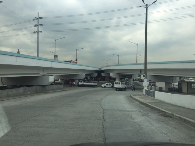 A look at the terminal located just beneath the two overpasses connecting Marcos Highway to C-5.
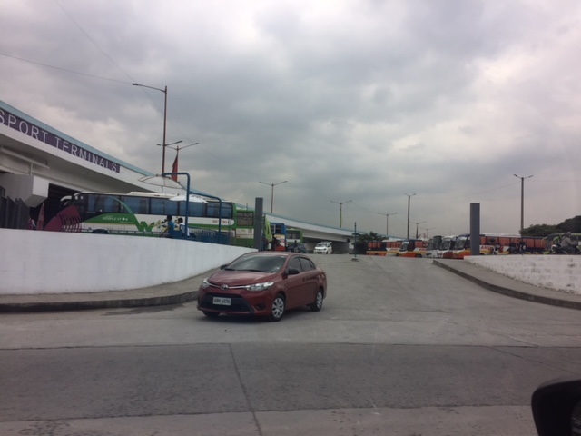 The driveway to and from the terminal lot.
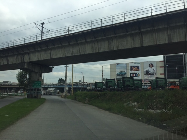 Moving towards SM Marikina under the LRT Line 2 structure, you see rows upon rows of trucks. I assume these are for sale and are there for display to prospective buyers.
 Leaving SM Marikina, this is the view of the trucks parked at the lot beneath the Marcos Highway and Line 2 bridges.
 Approach to the driveway of the terminal showing the buses currently at the BFCT.
 A closer look at the buses parked at the terminal. The green buses are RORO buses that the serve the West Philippine Nautical Highway route.
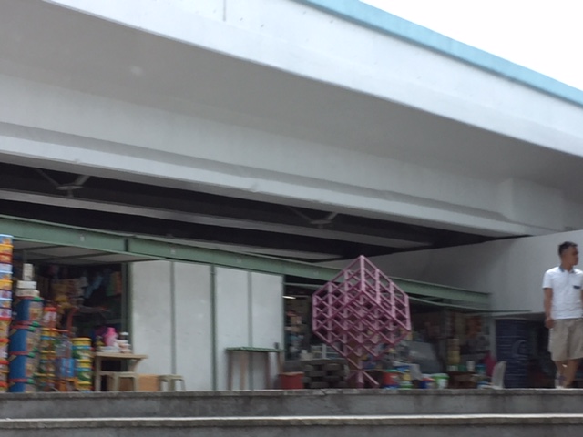 A quick look at some of the stores at the terminal. These are mostly the sari-sari/carinderia types you see in most provincial terminals. Among the merchandise are biscuits and cookies in containers of different sizes. These are popular pasalubong for travellers to relatives and friends in their destinations.
 The sign on the right is intended for vehicles coming from C-5 that are allowed to make a U-turn near the junction with Marcos Highway to get to the terminal. This, however, takes them into direct crossing conflict with vehicles coming up from the riverbanks heading to Marcos Highway.
It would be nice to see some statistics about the number of passengers using the terminal as well as their characteristics such as origins and destinations, including transfers (e.g., how do they get to or from the terminal and what modes do they use). I suspect that there are not so many people using this terminal and the numbers will not significantly improve once the Line 2 extension is completed and the new end terminal and its environs are developed in Masinag, Antipolo City.
–
Marcos Highway-Felix Avenue-Gil Fernando Avenue pedestrian overpass
Here’s are some photos of the pedestrian overpass structure at the intersection of Marcos Highway, F. Felix Avenue (formerly Imelda Avenue) and Gil Fernando Avenue (formerly A. Tuazon Avenue).
 Here’s a view of Marcos Highway and the elevated Line 2 Extension from the structure crossing Felix Avenue between Soliven/Tropical and Sta. Lucia. Also shown is the overpass crossing Marcos Highway.
 View towards Sta. Lucia and Robinsons Metro East
 Stairs to Sta. Lucia – notice the gap in the railings along the elevated Line 2 superstructure? That is where the Emerald Station will be constructed.
–
On the East Metro Transport Terminal in Marikina
This site has been visited a lot the past few days by people searching for information on the eastern transport terminal that’s being developed in Marikina City just across from SM City Marikina. I wonder if its for a study (i.e., students doing research) or perhaps some folks curious about the signs they’ve seen while crossing the Marcos Highway bridge across the Marikina River.
 Signs informing people about the existence of a transport terminal beneath the bridge
The sign also states BFCT, the first part of which are the initials of the former MMDA Chair/Marikina Mayor. CT probably means ‘city transport’, ‘city terminal’ or ‘central terminal’? I haven’t been to SM Marikina lately so I haven’t had the opportunity to see how complete the facility is and if it is already operational. However, one can see from the bridge, as you travel along the outermost eastbound lane, that work is ongoing and there are vehicles (mostly vans, jeepneys and small trucks) that are parked there.
Is this a good location for a public transport terminal? I believe so; considering that there is a railway station nearby and the area is a convergence point for a lot of people (not only those residing in Marikina and Pasig). Do I think this should be a provincial bus terminal of the same level as the ones proposed for the north and south of Metro Manila? Yes, but only for trips bound for the east (e.g., Rizal and Infanta, Quezon) and south (e.g., Quezon, Laguna, Bicol) via the eastern route (Marcos Highway, Antipolo-Teresa Road or Manila East Road). I don’t think it is appropriate for trips heading to Boracay, Baguio or Ilocos. Buses headed for the latter destinations should terminate at the proposed north and south terminals. Buses to/from those places that would be terminating in Marikina would mean they would have to travel along C-5 in order to get to this eastern terminal. If these are in significant numbers then the traffic generated by such a terminal will contribute to congestion along C-5 and Marcos Highway. Of course, such proposed terminals should be subject to rigorous studies as these facilities can be major traffic generators and some mitigating measures must be in place to address potential issues.
–
Responding to the transport impacts of road crashes
Last March 9, traffic was terrible along Marcos Highway and roads connecting to it including Imelda Avenue and Sumulong Highway due to a truck that slammed into the scaffolding of the Line 2 Extension across the Sta. Lucia Mall, and barely missing the newly constructed column supporting the girders and elevated tracks of Line 2.
 [Photo not mine but sent by an officemate who was glad to have taken his motorcycle that day instead of commuting by car.]
Following are comments I captured from Waze as I tried to get information about the traffic situation:


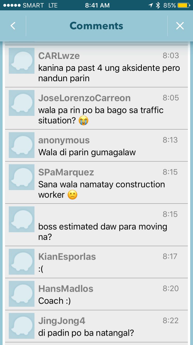

It is very clear from travelers’ comments that most were frustrated and many were angry about what seemed to be a very slow response from authorities in clearing the crash site and getting traffic to move faster. I myself wondered how a crash like this with its impacts manifesting in severe congestion along major roads was not dealt with as urgently as possible by so many entities that were not without capacity to act decisively. The front liner should have been the Metropolitan Manila Development Authority (MMDA) and there were at least four local government units directly affected by the congestion: Pasig, Marikina, Cainta and Antipolo. Surely, these LGUs could have done more if the MMDA couldn’t, in order to resolve the problem? If the availability of heavy equipment was an issue, weren’t there available equipment from Line 2 contractor, DMCI, or perhaps from the construction sites nearby (Ayala is constructing a huge mall near the area.)? Surely, they could lend a payloader or mobile crane that can remove the truck or at least help unblock the area?
I finally decided to turn back and work from home instead that day. Later, I learned that authorities had to stop traffic along Marcos Highway around 11:00 AM in order to tow the truck and clear the area for traffic to normalize. I hope this serves as a lesson in coordination among government entities and that future incidents like this will not results in a “carmaggedon” like Friday’s congestion. One thing that also became obvious is that travelers passing the area are all dependent on road-based transport and the primary reason why a lot of people were affected by the crash. The expanded operations of the Line 2, whenever that will be, will surely change transport in these areas and for the better.
–
Where exactly will the Line 2 Extension stations be?
A good friend asked me about where the two additional stations of the Line 2 Extension will be. Most articles state that there will be a station at Masinag and at Emerald but since work on the stations has not commenced then many are still speculating on the final locations and how the station will be laid out with respect to the elevated tracks. However, if you look closely, you will see something like a hint to where the stations and their platforms will be laid out. Following are two photos; each showing features of the elevated tracks that taper off at what looks like the start and end points for the stations.
 Future Emerald Station in front of Robinsons Metro East?
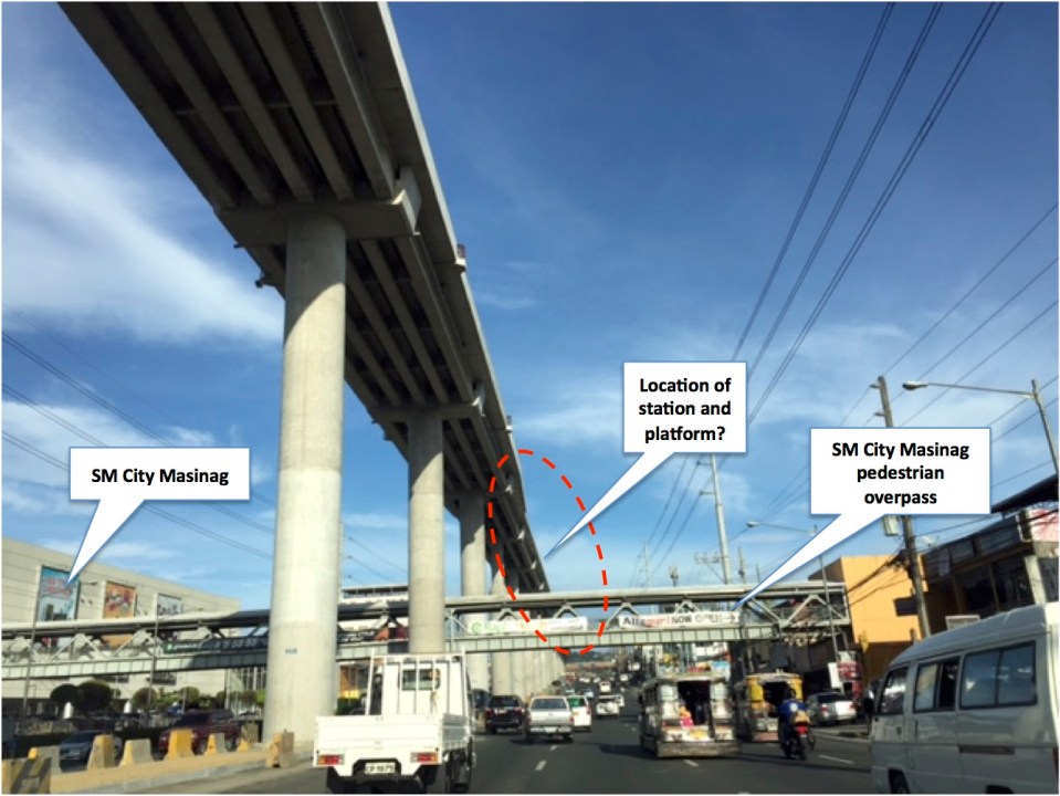 Future Masinag Station across SM City Masinag
Another observation and particularly at Masinag is how tall the structure seems to be. The platforms appear to be already at the 4th level if you compare the elevated tracks to the pedestrian overpass that represents the 2nd level. It seems that the Masinag Station will be quite a tall one and invites more questions from observers especially prospective and current users of Line 2. Perhaps it will be 4-storey building with commercial spaces for shops and restaurants? How massive will this structure be? Will there be a connection with SM other than via the existing pedestrian overpass? How will the inter-modal needs be addressed by the station design? Will there be more parking or maybe park-and-ride facilities? Hopefully, these questions can be answered soon.
–
Updates on the Line 2 Extension: What’s next?
Marcos Highway is part of my regular commuting route and so I have been able to observe the progress of the construction of the elevated tracks for the extension of Line 2. The contractor, DMCI, is nearing the completion of their part of the project. Unfortunately, the stations and the electrical/power systems for the extension have not been bidded out by the DOTr and so there are not a few doubts whether the extension will be operational by 3rd quarter of 2017, which is the original completion date for the whole project. The construction of the two stations alone are expected to take some time and also will have a big impact on transport and traffic despite the construction sites being more concentrated around the stations at Emerald and Masinag. Here are a couple of photos showing what it looks like along Marcos Highway.
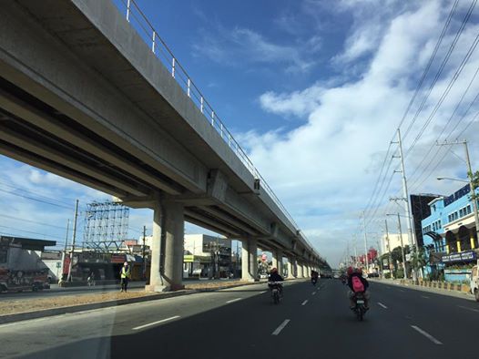 DMCI has almost completed clearing the stretch of Santolan to Masinag of their equipment. The barriers that delineated their work space are mostly gone, freeing up a lane each along either side of Marcos Highway. This has eased traffic along this major thoroughfare connecting Metro Manila to the east.
 The pedestrian overpass across Vermont Royale has been retrofitted so the center section passes under the Line 2’s structure.
Timing is of the essence for the two additional stations of Line 2. As I said, the projected completion and start of operations was 3rd quarter of 2017. Of course, the last quarter of this year would still be most welcome but further delays mean more losses on the part of commuters and, overall, the government. Perhaps it was a mistake for the previous administration to have not included the stations in the package that DMCI eventually got and now has almost completed? Maybe the current administration should expedite the remaining parts of the Line 2 extension. This should prove how serious the current government is with its promises for better public transport (i.e., mass transport).
–
