
Home » Posts tagged 'Quezon City' (Page 2)
Tag Archives: Quezon City
The FVR Road and Bridge after Typhoon Ulysses
This is a continuation of the feature on the aftermath of Typhoon Ulysses (Vamco). I am posting this here as part of my archives on the floods in the Marikina Valley.
There’s a road branching off from Marcos Highway that links to a bridge crossing the Marikina River and connects with the FVR Road along the Marikina Riverbanks. The following photos speak for themselves in as far as the mud and garbage that was left after the floods subsided.
 Descending from Marcos Highway, only one of two lanes are passable after heavy equipment moved tons of mud and garbage to the roadsides. The fences trapped a lot of garbage, too, as seen in the photo.
 Piles of mud and garbage at the service road leading to the east bank of the Marikina River and the SM Marikina access road.
 Under the Marcos Highway Bridge, garbage, mostly plastics, remain on the wire fences. This area was totally submerged during the height of the floods with water reaching the underside of the bridge. Fortunately, the bridge seems undamaged.
 Even lamp posts and electric poles caught a lot of garbage.
 The Olandes housing development was surely affected by the swelling of the river.
 The FVR Road leading to C-5 is already clear for 2-lane traffic but you can see the mud and garbage all around. The dried mud has turned into dust (alikabok) that blows away as vehicles pass through the road. There is also mud on the plants in the median planters as this area was also submerged during the height of the typhoon.
–
Tumana during and after the flood
I was heading to the office the Monday after Typhoon Ulysses had devastated wide areas in Luzon. I was aware of the congestion along my usual routes so I used Waze to guide my trip. Waze took me to Tumana instead of Marcos Highway, which I assumed would have been less congested. I took the following photos in the Tumana area:
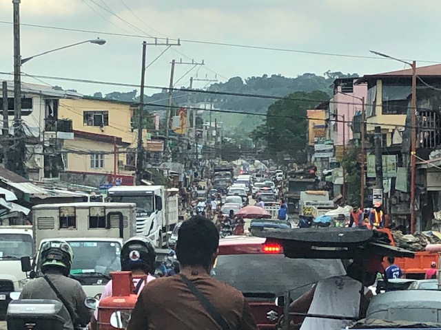 Congested main road due to heavy equipment like bulldozers, backhoes and dump trucks clearing the mud and trash in the area. There were also lots of parked vehicles along each side of the road including Marikina service and emergency vehicles.
 There was trash all around that included what looked like the belongings of people residing in the area. Many people were busy clearing their homes of items destroyed or damaged by the floodwaters.
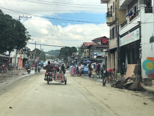 Despite being cleared for traffic, you can see the mud and water still in the area and signs of how deep the flood waters were by markings on the buildings.
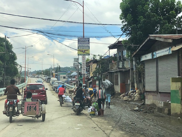 At the foot of the bridge connecting to Quezon City, you can see that there is still so much mud in many areas especially those closest to the river. Sidestreets were so narrow that the heavy equipment cannot enter them and cleaning the mud had to be done entirely manually.
 Here are what looks like the vehicles that survived the floods. I thought people must have rushed to get their vehicles on the best positions atop the bridge when they realized the waters were rising fast. It was likely few if anyone left their vehicles there during the height of the typhoon. That’s because the winds were so strong that perhaps people though it would be unsafe to leave their vehicles exposed to the winds.
The following photos from Facebook shows the extent of the flooding that reached the other side of the river – Loyola Grand Villas and another subdivision that’s directly along the banks of the Marikina River. The first photo shows the submerged end of the bridge from the LGV side in the foreground and Tumana in the background at the other end of the Tumana Bridge. The second photo is atop LGV and shows many submerged homes and cars.
 Only the cars on the bridge likely survived the floods.
 This was definitely at the level of the floods of Typhoon Andy (Ketsana) given the spread and depth of the floods.
One wonders what is now the return period for these typhoons. Ondoy was 11 years ago and the monsoon (Habagat) rains that also brought heavy rains and floods were in 2012 (8 years ago). Such floods cannot be solved by improving drainage systems alone but have to go to the root cause of flooding while also addressing how people could cope with these phenomena. Infrastructure alone cannot solve this and certainly will cost a lot for any initiative to provide some relief from such.
–
Aerial photo: Diliman, Quezon City
The aircraft we were flying on in a recent trip circled on the approach to NAIA and we were afforded some terrific opportunities to take aerial shots of Quezon City. This was before the rains of the Christmas holidays so the skies were clear of clouds. Here is one of the photos I took showing the University of the Philippines Diliman campus.
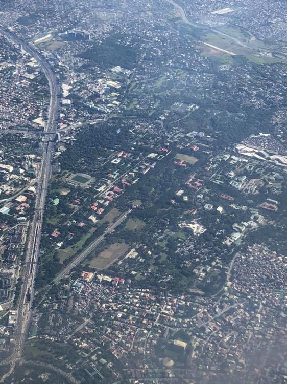
That wide road on the left is Commonwealth Avenue and you can see part of the Elliptical Road at the bottom left. There are few large patches of green in Metro Manila and many are in the largest city – Quezon City. You can see that these include the campus and Balara.
Aerial photos are no longer that rare these days as there are many who take shots from drones. Then, of course, there are shots like these you can take from the plane you’re riding. Have a nice Sunday!
–
On Quezon City’s Kalayaan Avenue bike lanes
Another example of what can be called “pwede na iyan” bike lanes are those found along Kalayaan Avenue in Quezon City. To be fair, the city made an effort to paint the bicycle lane and put up signs for this. However, one will observe that there is poor enforcement in relation to the bike lane as you would find vehicles parked on the lane. There is also the question of bicycle traffic as there doesn’t seem to be many cyclists along Kalayaan, making the space fair game for other vehicles including tricycles and motorcycles. Then there is the matter of connectivity. The Kalayaan bike lane seems to be isolated and does not have a connection to any other bike lane. The lane around the Elliptical Road, for example, is in the inner side of that road. Teacher’s Village does not have bicycle lanes but perhaps it is not (yet) necessary to have exclusive lanes in the still predominantly residential area (note: commercial establishments are still on the rise along major roads in the village).
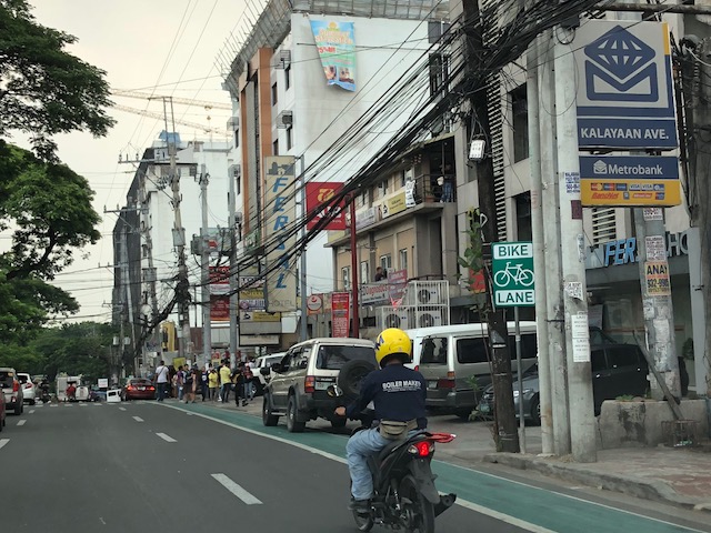 Vehicles parked on the Kalayaan Avenue bike lane
 Free flowing traffic along Kalayaan – notice the vehicles parked on the sidewalk?
One big question comes to mind with regards to such bike lanes: How do we improve the situation in order to encourage more people to bike? There are many answers to this question and the answers branch out to the infrastructure, policy, social and even societal, and other aspects concerning cycling. What we should bear in mind and what Quezon City and perhaps MMDA should work on is a strategy for promoting non-motorised transport (NMT) that includes walking and cycling that can be implemented metro-wide with safety and efficiency (incl. connectivity) as the main objectives rather than have piecemeal projects for show or demonstration.
–
Updates on the MRT Line 7 construction
I recently posted some photos showing the progress of work on the Line 2 Extension. This time, I wanted to show photos on the progress of the Line 7 construction along Commonwealth Avenue. Following are some photos my companion took this morning as we headed for Novaliches. Work continues along this major corridor even on Sundays. While it has caused much congestions and therefore inconvenience, the continuous work offers hope to those who will benefit from this mass transit line once it becomes operational.
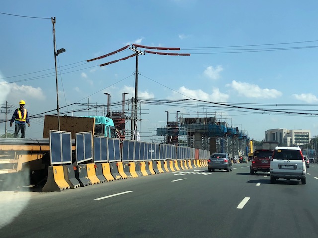 Columns rise along Commonwealth Avenue just across from the Ever mall and St. Peter’s church.
 Here’s a traveler’s view of the ongoing construction along Commonwealth Avenue.
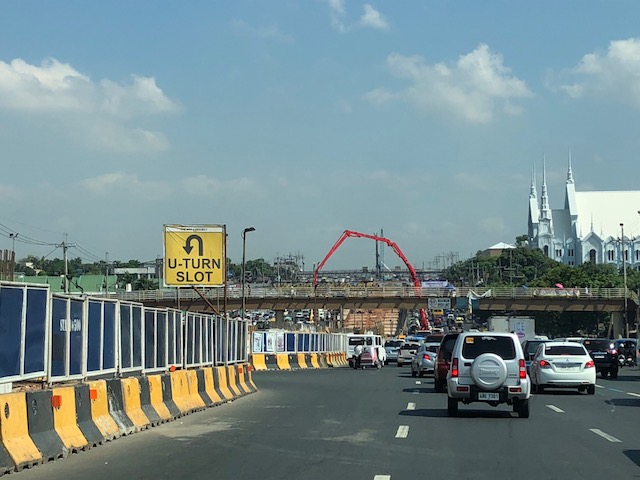
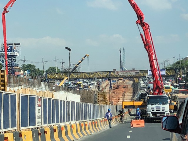 Concreting even on Sundays – it was quite congested today near the Fairview Market due to lanes occupied by heavy equipment including several concrete mixers lined up along one lane to supply the mix.
I have several former students who are now working on the Line 7 construction in various capacities. I usually get my updates from them. I am happy for them to be involved in such a major infrastructure undertaking. Hopefully, their experiences will be useful for other future railway lines in the country.
–
Will a flyover at Katipunan-C.P. Garcia solve the traffic problem in the area?
I read a news article about the proposal by the Department of Public Works and Highways (DPWH) to construct a left-turn flyover at the intersection of Katipunan Avenue (C5) and C.P. Garcia Avenue in Quezon City. The flyover is supposed to be for vehicles turning left from the northbound side of Katipunan to C.P. Garcia Ave., which goes through the University of the Philippines Diliman
Will the flyover solve the traffic congestion problem in the area, particularly at the intersection and Katipunan in general? I would say no, it would not solve the congestion problem both for the intersection and for Katipunan. This assessment is due to the following reasons:
- The overpass does not address the root cause of congestion in the area, which is trip generation related. There are many major trip generators along Katipunan alone including three major schools (UP, Ateneo and Miriam) and a mall (UP Town Center). Add to this the traffic generated by the high density residential developments along Katipunan (notice the high rise condominiums lining up across Ateneo and Miriam?) and the through traffic coming from various areas that use C5’s Katipunan section.
- Congestion is caused by saturated intersections corresponding to Ateneo Gate 3 and main gate of Miriam College. Traffic going in and out of these schools are favored over through traffic along C5 resulting in congestion in the area. Perhaps it would be more appropriate to build overpasses to bypass these intersections.
- Congestion is caused by vehicles bound for and coming from the UP Town Center. The congestion due to traffic generated by the commercial development is actually alarming considering it is not yet completed and trips attracted and produced is not yet at full potential.
- The heaviest flows at the Katipunan-C.P. Garcia intersection are along Katipunan (northbound and southbound through traffic). Logic and traffic engineering principles point to grade separation to be more appropriate for such traffic and NOT for the left turn movement. A flyover should also be able to bypass UP Town Center as vehicles bound for the mall already blocks traffic along both sides of Katipunan and directly affects the intersection.
I think the DPWH should do well to re-assess their proposal along the lines of the reasons I have listed here rather than continue with the folly of building a left turn overpass alone. UP Diliman should also resist this overpass as, based on the news article, it would mean UP giving up some 8,000 square meters of its property for the project. UP already has given a lot for widening C.P. Garcia but that goes without saying that a through flyover might also require UP to give up property and particularly from its National Science Complex for such a project.
–
Trip cutting with respect to the LRT Line 2
Trip cutting is one of the undesirable behaviors of public utility vehicle drivers. It is most common with jeepneys and UV Express than with buses.
The findings of the study completed by our students last June 2015 are the following:
- It was proven that trip-cutting behavior is a common practice by both jeepney and UV Express drivers with routes along Marcos Highway and Aurora Boulevard, covering parts of Pasig City, Marikina City and Quezon City.
- The underlying factors involving trip-cutting behavior by PUV drivers were found to be the following:
- Jeepneys and UV Express unload most of their passengrs during peak hours at the LRT Santolan and Katipunan Stations – there was a higher likelihood for passengers to ride the Line 2 from these stations to their destinations including Cubao and the University belt. A lot of passengers are students and trying to keep their schedules. Road transport can be very unpredictable and the trains offer more reliable travel times.
- Drivers can maximize profit by having shorter trips and at the same time having passengers at full capacity – jeepney and UV express drivers unloading most of their passengers at the stations and turning around there (i.e., cutting their trips) means they avoid the congestion along Aurora Boulevard and faster turnarounds translate to their being able to carry more passengers thereby earning more revenues.
- It was observed that the top trip-cutting routes for PUVs along Marcos Highway and Aurora Boulevard are as follows:
- For jeepney vehicles:
- Cogeo – Cubao and Antipolo – Cubao routes in relation to the LRT Santolan Station;
- Calumpang – Cubao and SSS Village – Cubao routes in relation to the LRT Katipunan Station.
- For UV Express vehicles:
- SSS Village – Cubao and Cogeo – Cubao routes in relation to the LRT Santolan Station;
- Marikina – Cubao and Rodriguez/Montalban – Cubao routes in relation to the LRT Katipunan Station.
- For jeepney vehicles:
The following recommendations were made in relation to the findings of the study:
- Route modification of top trip-cutting routes to take into account the realities with respect to the current demand.
- Study on supply of PUVs with respect to the Cubao terminal station in relation to trip-cutting violations.
- In the future, when the construction of the LRT Line 2’s Masinag and Emerald stations is completed, it is recommend to that further route modifications be made relative to these new stations.
Such studies are important especially in light of the construction of railway lines including this case of the extension of Line 2 from Santolan, Pasig to Masinag, Antipolo. There is an opportunity here for the rationalization of jeepney routes to complement the obviously higher capacity and more efficient trains of Line 2. Rationalization here translates to the shortening of jeepney routes with many units terminating at Line 2 stations. ‘Cogeo-Cubao’ jeepneys would become Cogeo-Masinag jeepneys while ‘Antipolo-Cubao’ jeepneys will become either ‘Antipolo-Masinag’ or ‘Antipolo-Emerald’ jeepneys. A Masinag route end would apply to ‘Antipolo-Cubao via Sumulong Highway’ jeepneys while the Emerald route end would apply to ‘Antipoli-Cubao via Junction’ PUJs. Such will reduce the travel distances covered by the jeepneys as well as reduce their travel and turnaround times. Also, such a rationalization will lead to a better structured public transport system following a hierarchy among modes.
–
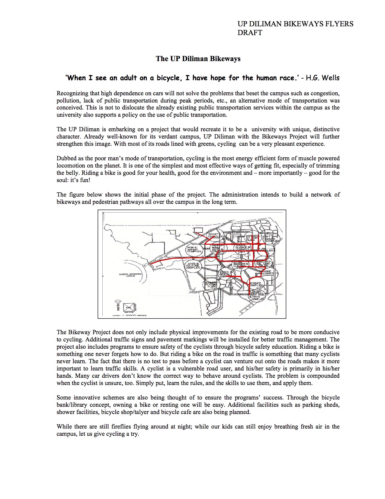
University of the Philippines Diliman Bikeways Flyer (2005)
Searching for material on the proposed bikeways network at the University of the Philippines Diliman campus, I came across a draft of a flyer. The flyer was intended for use in consultations with stakeholders including members of the UP Diliman community (e.g., staff, students, faculty and residents). I recall that there was also a committee established for the purpose of planning and implementing the UP Diliman Bikeways. Unfortunately, the network was not fully realised and took a few years before a major component was implemented but under a different project – the UP Diliman Model Traffic Safety Zone project.
A copy of the flyer in PDF may be found here:
The UP Diliman Bikeways Flyers 2005
At present, UP Diliman is again considering the bikeways network proposal and has initiated some studies towards determining its feasibility including what routes would be most viable. Incidentally, our students in one of the engineering elective courses offered by the Institute of Civil Engineering is currently surveying candidate routes and they should be finished with this task by middle of March. It would be interesting to see which “corridors” can be proposed as the next components of the network to be realised.
–
Enforcing bus lanes along Commonwealth Avenue
Commonwealth Avenue always seems to be the subject of road safety or traffic discipline initiatives every now and again. Quezon City together with partners in other government agencies like the Philippine National Police (PNP) and the Department of Transportation and Communications (DOTC) have embarked on another program aimed at reducing the occurrence of road crashes and other incidents along this busy corridor. It actually reminds me of the “traffic discipline zone” designation of Commonwealth not a decade ago and before public transport lanes were physically allocated along the highway.
They are failing miserably if I am to base success on observations of the behavior of drivers of public transport vehicles alone along this major highway. They get away with a lot of reckless driving including suddenly switching lanes, speeding, and tailgating. There are also cases where vehicles and pedestrians cross the wide highway at points that are prone to crashes. I am not aware of a lot of apprehensions being made of these reckless drivers along Commonwealth except perhaps at the foot of the Tandang Sora flyover where MMDA enforcers seem to be congregating on most days armed with one of two of the agency’s speed guns. But then it seems “business as usual” for the same drivers and riders along the rest of Commonwealth so the initiatives are not effective deterrents against irresponsible road use.
 You can always see buses on the wrong side of the road along Commonwealth Avenue especially along the section between Fairview Market and Regalado. They do this to get ahead of other buses and then bully their way to make a stop or turn right at an intersection.
 This bus in particular was weaving in traffic, bullying smaller vehicles to give way as it raced other buses along Commonwealth Avenue. Such behavior among public transport drivers is one of the major ingredients for road crashes.
It’s been a year now since the tragic crash involving an out of line provincial bus in the Cordillera. That was partly the result of poor monitoring and enforcement by the LTFRB. While the major reason for the crash was reckless driving (i.e., the driver was allegedly speeding at a critical section of the highway), this could have been avoided if the bus wasn’t operating in the first place. The very same policies along Commonwealth apply to these provincial buses and fatal crashes could’ve been avoided or minimised if the LTFRB can just exercise its mandate effectively.
–
Lane discipline
Among many peoples’ pet peeves in traffic would probably be the propensity for lane changing among many drivers and riders. This is especially true for wide multi-lane roads like Commonwealth Ave., Marcos Highway and EDSA. While it can be an understandable behaviour for free flowing traffic along long stretches where weaving can be executed safely, lane changes can be quite risky at intersections and may instantly lead to crashes. These are likely the bases for the swerving violations that the MMDA and other traffic enforcers became notorious for issuing for a time.
We chanced upon a scene at the Commonwealth Ave.-Mindanao Ave. intersection in Novaliches where a car seemed to have attempted to cut in front of a bus in order to make a turn but got hit by the bus. From the angle of the collision, it appears that the driver of the car likely maneuvered for a U-turn and made the critical assumption that he could beat the bus for the turn. It was obvious that the bus was in the right position while the car was not. This is often the case for drivers who do not care for positioning themselves along the correct lanes at intersections and seem to rely on their guile to get ahead of others. Such drivers might just be the same ones who would likely do counter-flows also to get ahead of others queued along the right traffic lanes.
 White car attempts to make a U-turn right in front of a bus and gets hit by the bus whose driver likely did not notice the white car sneaking in front of the vehicle.
Lane discipline becomes more important with the revival of traffic signals all around Metro Manila. In addition, it is also important for the appropriate lane markings to be placed at intersection approaches. Such markings are supposed to guide drivers where they should position themselves so that they will not block traffic going in another direction. These can also aid in the enforcement of lane discipline as vehicles on the wrong lanes can be apprehended. This was the case in Cebu City in the 1990s when the city adopted the SCATS traffic signal system, which employed detectors embedded on the pavement along the approaches to intersections. These detectors helped determine whether there is demand for a particular movement (left, through or right) and so requires lane discipline for the system to work effectively. –
