
I write this as a super typhoon is bearing down on us this 1st of November. I found this map on the internet without attribution to the original source. It shows a still-born Metro Manila with only four local government units: Manila, Quezon City, Pasay City and San Juan.
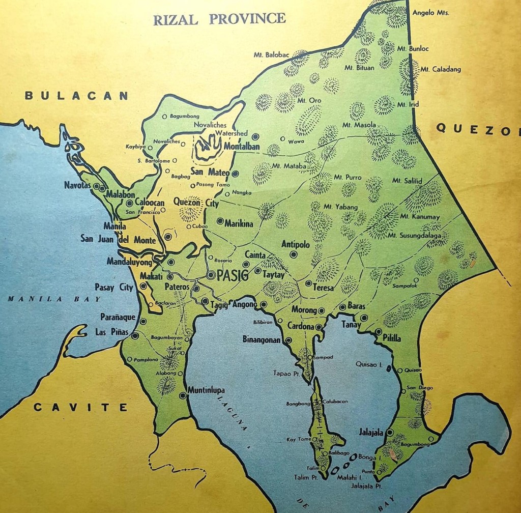
What if instead of the Metro Manila we have now, Rizal retained the towns (that eventually became cities) that were transferred to what became the National Capital Region (NCR)? These are Navotas, Malabon, Caloocan, Marikina, Pasig, Pateros, Mandaluyong, Makati, Taguig, Paranaque, Las Pinas and Muntinlupa. Valenzuela was taken from Bulacan Province. Pasig was the capital of the province (Yes, that’s why there is Capitolyo and the Rizal Provincial Capitol used to be in Pasig where you now have Capitol Commons. Surely, the political landscape could have been different though one could argue that certain families would have still held sway in cities/towns where they have their routes. Imagine, the governorship of the province would have been a coveted post but not by the the current holders but likely by personalities from the more progressive and densely populated cities. Governance would have been different, too, as Rizal would have both highly urbanized and rural areas. Perhaps certain undesirable politicians could not have emerged due to the dynamics of a province with highly urbanized cities? What’s your take on this “what if”?
–

I’ve always wondered about this as well!!
As Paolo Alcazaren always points out, typhoons don’t care about political boundaries. It became all too apparent with Ondoy in 2009. As it is right now, Metro Manila has no single governing body that makes it difficult to manage as one unit. If only the cities were still part of some bigger collection (like you said, as part of Rizal), then maybe coordination among different towns and cities wouldn’t be so difficult! As they are right now, they are several small “kingdoms”. 🙄
I broached this to a history prof friend years ago and he said it might have also been inevitable to have several kingdoms as those closest to Manila or QC (whichever would have been the national capital) would have developed quickly and as now would have strong ties economically with these. But, Pasig would have had a different growth and political families could have been quite different. Yung mga nasa Taguig ngayon baka hindi nag emerge. 🙂
Also, nowadays it’s funny to think that when you need to go to some northern Rizal towns (San Mateo, Montalban/Rodriguez) from the rest of the province, you’d actually need to go OUT of Rizal momentarily (via Marikina) to do so. There’s no other way!
Exactly, those two towns seem disconnected. I have a friend who recently traced the route connecting Antipolo to San Mateo and Montalban (I like the old name than the new) and meron naman but very rough roads. And you wonder why until now there seems to be no plan for a direct road kahit provincial man lang.
as a resident of san mateo, i find this disconnection as an advantage. it doesn’t take a while for us to go into marikina or quezon city. in my specific case, i remark often about how i can see the foothills of the sierra madre, and the houses of marikina just by turning my head to a different angle.
I’m from Marikina and looking at a Metro Manila map, it looks like the head of a cartoon character called Fido Dido (triangular-shaped face) Marikina looks like the “ears” of Metro Manila, half of the city is jutting out of Rizal Province.
I think if Rizal Province stayed the same as it was when it created in 1901, there would be no NCR but instead an NCP (National Capital Province) with modern-day Calabarzon (Reg 4A) probably being called CaLaBaZon or Calabatzon, whichever sounds better.
Also, with 16 HUCs, the OG Rizal Province would have been way richer, progress on the Eastern side would have been better. I believe the Ynareses would have not been a dynasty, maybe at municpal-level only, as Gubernatorial posts would be dominated by Metro Manila politicians, possibly, Jejomar Binay, Manny Villar, Bayani Fernando or Cayetano would have been provincial governors. The rest of Rizal would have had big ticket projects “funded” by the richer side.
Antipolo, San Mateo and Cainta, most likely HUCs by now. I don’t think “Western Rizal” politicians would intervene in their city bids, unlike the Ynareses, who have been very allergic of cityhood bids in fear of any of them files for “membership to Metro Manila” losing them revenues (e.g. real property taxes, business permits etc) but since hypothetically, there is no Metro Manila, then there’s nothing to fear really.
San Juan is also part of Rizal province way back then