
Buses tagged…now what?
The MMDA issued a memo requiring all Metro Manila buses to paint their license plates at strategic areas of the bus exterior. These include standard sizes for “tags” to be placed on the roof, front, sides and back of the bus that are supposed to clearly show consistency with the license plate. Needless to say, if the license plate and the painted tags do not match, then the bus will be labeled colorum or illegally operating. Tags are also colored according to the general routes of the buses, with the yellow background applicable to buses plying routes along EDSA while an orange background applies to non-EDSA routes like those along Ortigas Ave. and Quezon Ave.
The tagging seems to be the latest in a long list of schemes that have been implemented to address the issue of colorum public transportation. While this is generally a matter for the LTFRB, the agency with the mandate to regulate road public transportation, the enforcement aspect is really quite demanding for an agency with few personnel to do this. As such, the LTFRB is usually assisted by other agencies like the MMDA or local government units. Franchise enforcement, however, is generally not the province of the MMDA or LGUs unlike their being deputized by the LTO in enforcing traffic rules and regulations (thus allowing the MMDA and LGUs to issue traffic tickets). The deputized MMDA and LGU enforcers may apprehend public utility vehicle drivers for traffic violations and in an ideal set-up, such violations should be considered when evaluating franchises for renewals. The propensity for violating traffic rules and regulations is a manifestation of poor driving habits and unsafe behavior on the road. Again ideally, such should be taken against operators who have the responsibility for hiring and training their staff. Operators should be held accountable should there be a high incidence of traffic violations and especially when there are incidences of crashes.
I am curious as to how the MMDA will be taking advantage of the bus tags in managing not only public transport but overall traffic as well. The tags present an opportunity where data collection may be facilitated and for various purposes. Such include a variation of the license plate surveys that are usually conducted to trace the movement of vehicles and determine whether they are speeding or travelling too slowly. An application of the outcomes of such surveys is the estimation of travel time along particular routes. For enforcement purposes, one can determine the reasonable turnaround time for public transport vehicles and allow for the checking of trip-cutting and the verification of the incidence of multiple plates. With the video cameras located at strategic points along Metro Manila’s major thoroughfares, sophisticated software employing image processing may be able to expedite the process, an example of an intelligent transport systems (ITS) as applied to public transportation.
The MMDA could even go further by consolidating travel time/speed data from public transport vehicles in order to derive real-time road network statistics. These could easily be visualized using digital maps that can be made online and shared to motorists and commuters alike to allow for better travel planning around the metropolis. Travel time/speed data have been used by researchers and agencies in other countries to estimate road traffic performance throughout the day and may be employed in modeling traffic in order to predict travel characteristics given typical factors affecting the traffic stream. Private vehicle characteristics are approximated by taxis that operate pretty much like private vehicles given that they do not have fixed routes and are not confined to lanes normally assigned to buses and jeepneys.
Such a comprehensive and sophisticated system for traffic management would require that all public transport vehicles be tagged including jeepneys and taxis. This also requires both hardware and software, and most importantly, capacity and on the part of Perhaps this is an alternative to requiring all to have GPS or RFID installed. Of course, the latter devices have more applications due to their potential for data storage (e.g., vehicle registration, franchise, location, etc.) but unfortunately, there are issues that still need to be addressed and questions left unanswered that are associated with these devices. Sayang! But even so, the bus tags (and maybe jeepney and taxi tags in the future) already present a lot of opportunities for monitoring, evaluation and improvement of traffic in Metro Manila. If only such potential can be realized and maximized by the MMDA and other agencies…
Still on Katipunan
Katipunan is again the subject of attention thanks to the Sunday newspaper article by Prof. Randy David in his column at the Inquirer. The problem is not really new and I have been familiar with the congestion and its derivatives from the time I first studied in UP Diliman in 1988 and up to now when I continue to pass through the avenue between home and workplace.
I was able to dig up a 2003 study on Katipunan conducted by the National Center for Transportation Studies (NCTS) of UP for a consortium chaired by then DENR Secretary Bebet Gozun. The study was the group’s response to the MMDA’s effort to install their U-turn scheme along Katipunan, encouraged at the time by the scheme’s apparent success along Commonwealth and EDSA while not acknowledging the problems experienced along Quezon Avenue. The photos below were taken during the time when the study was being undertaken and are very much the same picture of Katipunan today during the peak periods.
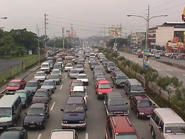 Figure 1: Morning traffic congestion in 2003 along the northbound direction of Katipunan Avenue in front of the Ateneo De Manila University (notice that there was no U-turn slot near Gate 2 at the time)
 Figure 2: Ateneo-bound vehicles blocking through traffic along the service road and the Aurora flyover
The study involved contributions from most if not all stakeholders including Ateneo and Miriam, the private sector and civil society groups, the Transportation Science Society of the Philippines (TSSP), and some government agencies particularly the DENR, who convened the group to formulate an alternative to the MMDA’s initiative that was personally being pushed by its then Chair Bayani Fernando. I reproduce below, word for word, the conclusions and recommendations from that 2003 study:
{Conclusion}
“After a thorough evaluation of the traffic problems along Katipunan as well as the solicited and unsolicited solutions from stakeholders, it becomes clear that the answer to the Katipunan traffic question is not the introduction of the U-turn scheme into the system. Indeed, while the U-turn scheme has met with relative success along major thoroughfares including Marcos Highway and Commonwealth Avenue, it has also contributed if not created congestion along Quezon Avenue. The notion that “success in EDSA and Commonwealth means there is no reason why the scheme won’t work in Katipunan” would not hold water in the light of the requirements for effective implementation of U-turns. Simply said, the traffic volume along Katipunan during the peak periods alone will assure that the U-turn scheme will cause more congestion rather than mitigate it.
{Recommendations}
- Optimization of traffic signals – coordination of signals need to be implemented particularly for the intersection pairs identified in this report. The Traffic Engineering Center (TEC) must be consulted with respect to the operation of the traffic signals along Katipunan.
- Restriction of roadside parking – parking restrictions must be strictly enforced and establishments along Katipunan should adhere to the required parking slots corresponding to the traffic they generate.
- Removal of parts of the islands to improve flow – geometric improvements to ease flow (i.e., increase road capacity) may be explored. Note that this report is not entirely opposed to removal of parts of the islands. However, their outright removal with the trees for the sole purpose of the U-turn scheme is not acceptable to most stakeholders. This must be carefully evaluated.
- Construction of an internal road between Ateneo and Miriam – the internal road will allow common vehicles to circulate within the campuses thereby eliminating traffic that would otherwise make several entries and exits to the campuses via Katipunan.
- Open additional gate at Ateneo – the possibility of opening another gate at Ateneo between the existing Gates 2 and 3 must be explored.
- Encourage carpooling or car-sharing – it is strongly recommended that Ateneo and Miriam consider carpooling or car-sharing schemes. It has been found that traffic along Katipunan is primarily composed of private vehicles will low occupancies bound for the two schools. While the surveys showed high return rates from grade school and high school students, very low returns came from college students. It is these people who account for a majority of the vehicles that clog Katipunan and they should take part in the formulation and implementation of such schemes that would lead to a significant improvement to traffic along Katipunan.
- Strict implementation of the zoning laws – this last recommendation points to the inconsistency in the granting of building permits to developers of high-rise condominiums along Katipunan. This is a constant issue and a controversial one since residents in the area and the two major schools (Ateneo and Miriam) have always opposed the “spot zoning” practice along Katipunan.” (NCTS, Study on the Traffic Management of Katipunan Avenue, 2003)
The study recommended alternative solutions in lieu of the U-turn scheme for Katipunan Avenue that was at the time being pushed by the MMDA as the solution for traffic congestion in the area. The recommended measures considered different aspects: traffic management per se, geometric improvements or road construction, travel demand management, land use, and other measures. However, it seems that 8 years after there has been practically no change in conditions along Katipunan Avenue.
The support and commitments of the different stakeholders (academic institutions, residents, business establishments, professional organizations, government agencies, and concerned citizens) are essential for the successful implementation of the recommendations contained herein. It is only through a strong partnership that sustainable and long-term solutions to the traffic problems in Katipunan Avenue can be achieved.
However, it is realized that there should be some sacrifices involved including a dramatic or drastic change in the travel behavior of those mainly responsible for the congestion. The vehicle trip generation of both Ateneo and Miriam are the roots of the problem and their continuing resistance to proposed solutions while not offering any viable countermeasures or proposals will only serve to perpetuate congestion in the area even as the external costs associated with the traffic they generate spread to a larger area. Recent studies at the UP Diliman, which is an open campus, has shown that private vehicle through traffic (i.e., traffic that has nothing to do with UP) has also grown and most of these are Ateneo and Miriam-bound trips.
It seems awkward and even confusing to see that 8 years after what was perhaps the last (maybe even the first?) serious look into Katipunan traffic, conditions have only worsened. This is due to additional developments in the area including high density residential projects that also tend to generate a lot of traffic, and commercial establishments that do not provide sufficient parking spaces. But although these contribute to congestion, their vehicle generation pale in comparison to that of the schools in the area. This is perhaps a case where one is able to see the flaws of others and yet refuses to look in the mirror to see for oneself something that needs critical attention.
Experiences and lessons on land use and zoning along Katipunan
Last Friday, a rally was held just outside the Ateneo De Manila University along Katipunan Avenue to protest the construction of Blue Residences, one of the SM group’s high-rise condominium projects that is located near the corner of Katipunan Ave.-Aurora Blvd. where a mini golf course and a few small shops used to be. The protesters wielded placards stating what could have been applicable to many of the developments now standing along Katipunan and just across from Ateneo and Miriam College. This is not really a new issue the protesters were dealing with but something that, dare I say, has festered for quite some time now.
The issue of land use and zoning along Katipunan is a continuing struggle against what the Quezon City government has maintained as its policy for “spot” zoning to accommodate high density residential and commercial development along a stretch of Circumferential Road 5 that used to be predominantly low density with small shops and restaurants lining the west side of the road and separated from the main highway by an island and a two-way service road where local traffic including tricycles flowed. This was the Katipunan I first started to be familiar with in the late 80’s when I entered UP as a freshman. Miriam was still known as Maryknoll at the time and was run nuns prior to it becoming the secular but still Catholic institution that it is today.
Traffic was more manageable along Katipunan then and a fleet of blue school buses served the Ateneans. It was a case of high occupancy transport that sadly has digressed to high vehicular volume, low occupancy traffic that Ateneo and Miriam are associated with today. Tricycles then were confined to the west service road and crossed Katipunan only at the intersections, which were strategically located just across from the main gates of Ateneo and Miriam. These intersections used to be signalized but the settings were often manipulated to favor Ateneo and Miriam traffic during the peak periods, much to the frustration of through traffic.
Fast forward to the present when the service road was removed along with the island to given way to what the previous MMDA dispensation referred to as a clearway policy to encourage faster traffic speeds combined with the much maligned U-turn scheme as applied to Katipunan. The smaller shops and restaurants have been replaced by condominiums and other establishments that have generated much traffic (not that Ateneo and Miriam have not been responsible for congestion) and which obviously do not have enough parking resulting in cars parked all over along the avenue and effectively reducing road capacity.
An article written by Randy David through his regular column at the Philippine Daily Inquirer came out today to speak about the Professor’s personal experience about Katipunan and his granddaughter’s views on development. Entitled “Katipunan Blues,” it presents a very honest and a very common observation of what Katipunan has become through the years and what different generations think about the development (or degeneration) along the particular stretch of the avenue. Its conclusion is something to ponder about and applicable not only for Quezon City and the rest of Metro Manila but for other cities across the country as well.
Is it too late for Katipunan given all the developments that have been permitted along this road? Did the universities do their part to prevent this in the first place? Or were they part of what Katipunan is today? Does Quezon City (or other local governments for that matter) even know what land use planning is about and what its policies on accommodating development have brought about in many other place? Could the DENR through its EIA process or the HLURB through its own instruments have prevented the deterioration of communities? There seems to be too many questions and we’re running out of answers for these.
Perhaps the answers were there but authorities and officials responsible refused to take heed of these or turned a blind eye to the issues. Perhaps the various developments and SM Blue were allowed because local governments became too eager for developments that also have been equated with revenues for the cities. Still, established systems and processes like the DENR-EMB’s and the HLURB’s are supposed to be there to ensure responsible and appropriate development.
We are often dumbfounded at what has actually happened and the outcomes clearly show our failures. Perhaps we are too blinded with the notion of development that we forget that it is also our responsibility to guide proponents. A lot of soul-searching should be undertaken to rethink how we plan and develop our cities. Such should properly incorporate principles of sustainability including those that address issues pertaining to transport and land use. We have a long way to go towards sustainable development as applied to city planning and development. But we need to start now if we are to even achieve a fraction of what we’d like our cities, our communities to become. We also need for champions to come forward among our current leaders and officials if only to bring order to what is perceived as chaotic development.
Is there a need for a transport infra master plan? – responses to comments and questions
Is there a need for a transport infra master plan?
The NCTS crafted an issue paper for Bantay Lansangan entitled “Is there a need for a transport master plan?” partly as an exploratory initiative to widen the perspective of the organization from its current focus on roads.
Master plans are supposed to be guides for both government and other interested parties such as the private sector for determining what projects are to be prioritized. They also should be able to provide the basic cost estimates and other requirements that should pave the way for more detailed planning and design for specific or particular projects. As such, the absence of master plans or perhaps outdated ones is considered as handicaps in the prioritization and implementation of projects.
However, despite the availability of master plans, there is the question of the acceptance of their recommendations. There are also questions pertaining to how comprehensive these plans are and how would be able to address social, economic, environmental and even political issues should certain projects be implemented and the plan realized. On the last concern on the political aspect there are also those projects that are altered, apparently according to the whims of national or local leaders. Such deviations can be unnecessary and may lead to increased costs for project implementation. As it there have been many master planning studies conducted for the Philippines, the main issue tackled by the paper is the lack of an integrative document, a master plan for all master plans so to speak, that will clearly show how each and every major project is linked with the others.
The paper aimed to:
- Situate what has been initiated in the past vis-à-vis infrastructure master plan;
- Discuss the present framework (if any) that guides government’s long-term investments, policies and projects in infrastructure;
- Highlight the key concepts and processes involved in the formulation of an infrastructure master plan;
- Identify gray and problematic areas; and
- Identify recommendations and ways forward.
I reproduce below the concluding section of the paper:
“Master planning studies are generally directed to the government and provide frameworks for where investments should go. These include recommendations concerning prioritization that is reflected in the implementation periods or targets mentioned in the plan. Projects where the private sector may invest in should seldom deviate from those included and proposed in a master plan. This ideal situation would presume that unsolicited proposals are generally classified among non-priorities. Otherwise, it would seem that the master plan is flawed and failed to identify projects that are attractive for investments. More often than not, private sector entities will also have their own views on which projects will be most profitable and therefore most attractive for them to venture into. It is the government’s responsibility to ensure that plans are implemented according to their importance or urgency.
There is a need for long-term infrastructure master plans. However, these should be updated on a regular basis and not premised on the availability of foreign funding support as the long-term eventually becomes part of the medium-term and ultimately the short-term. Infrastructure master plans should also be flexible as it serves as a guide not only for potential loan packages but the participation of the private sector in putting up the infrastructure essential for the sustainable progress of the country. Lastly, it is important that coordination be clear in the master plans should these be formulated according to the different transport sub-sectors. Elements must be integrated to ensure that the different transport infrastructure projects complement each other rather than appear as isolated or disconnected.”
The paper was presented last August 1, 2011 at the DPWH-BL Fair held at the DPWH headquarters at the Port Area in Manila. It was generally enthusiastically received based on the feedback I got from our technical staff who presented the paper before a predominantly DPWH audience. I will address questions and comments forwarded to me in the next posting.
Pedestrian overpasses along Commonwealth Avenue
Commonwealth Avenue is still regarded as a “killer” highway despite the efforts to reduce road crash incidence along this thoroughfare. Many of these crashes involve pedestrians who continue to cross the highway on at-grade or on ground level at many points of the highway despite this being prohibited or discouraged. To cross the avenue, pedestrian overpasses have been constructed at strategic locations along the highway including those at Fairview Market, at Ever/Shopwise and at Tandang Sora, at U.P. (2 overpasses – one at AIT/CHK and another at Technohub), and at Philcoa. Despite these facilities being constructed and possibly with a few more to be constructed in the future, many people still choose to jaywalk. Among the reasons cited are stairs being too steep and the long distances they have to walk to and from the overpasses.
Following are photos taken on a Sunday drive from Novaliches to UP showing the conditions on and around overpasses along Commonwealth Avenue. Noticeable are overpasses across Fairview Market and Ever/Don Antonio where vendors have set up shop and impede the flow of pedestrian traffic.
 Pedestrian overpass across Commonwealth at Litex and before Fairview Market (section is at Commonwealth southbound) – the overpass is surprisingly free of vendors despite its being well within the influence area of the market.
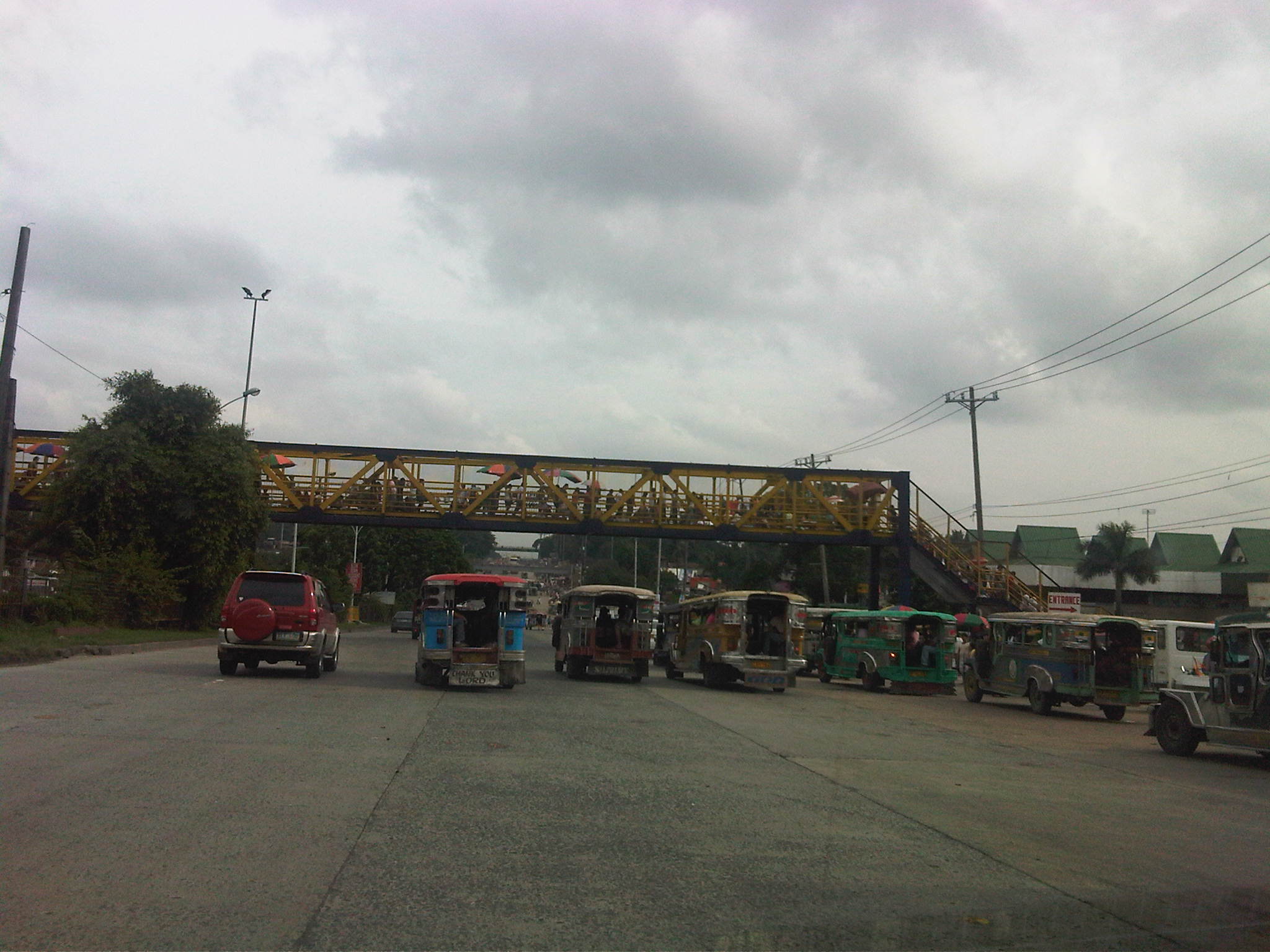 Overpass across Fairview Market (section is across Commonwealth southbound) where vendors have set up to sell various merchandise. Notice the umbrellas to shield vendors from the elements. Note, too, the jeepneys congregating under the overpass and taking up 2, 3 or even 4 lanes of road space and thereby causing congestion along the wide avenue.
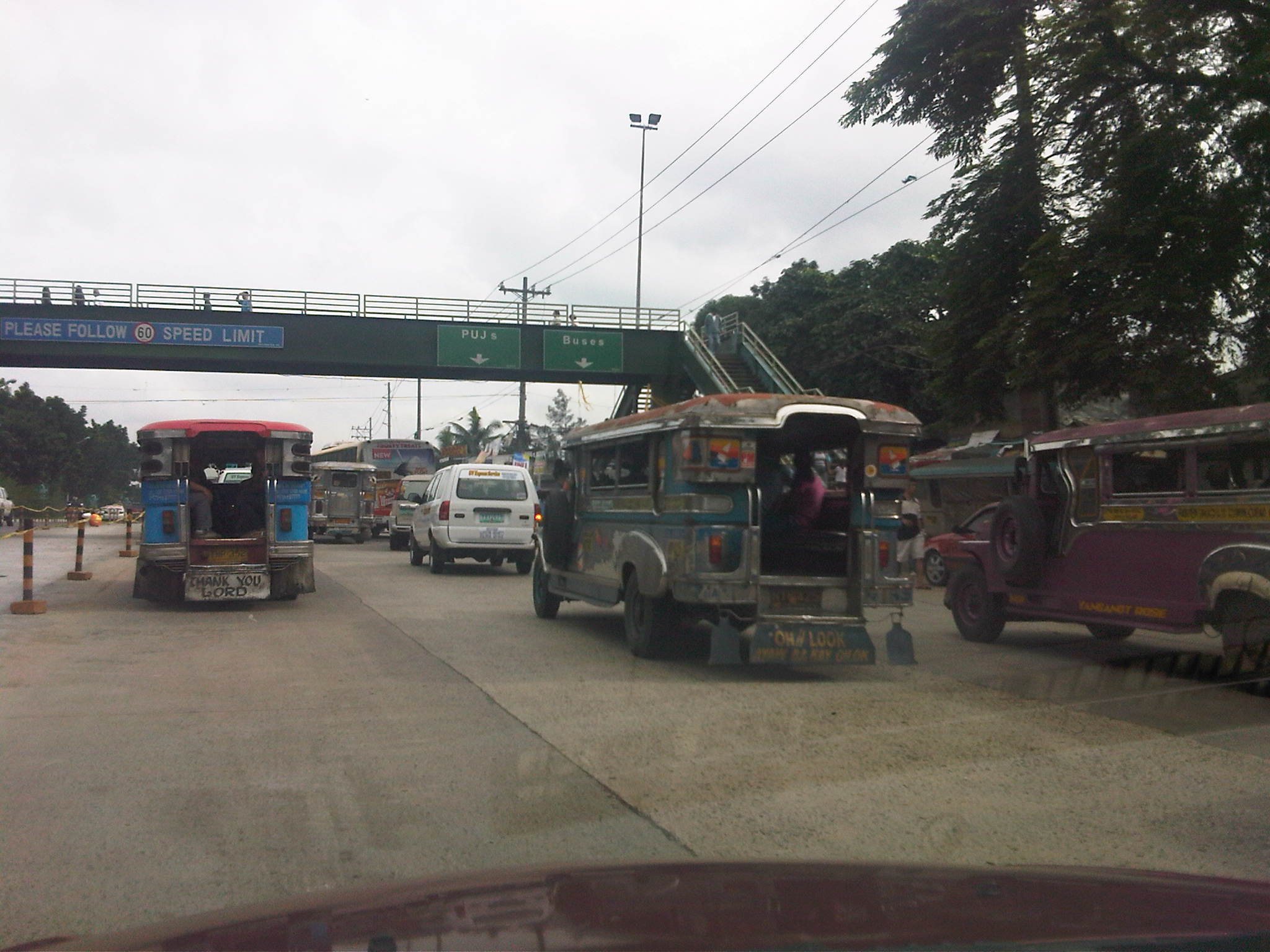 Overpass after Fairview Market and across densely populated areas that are mostly informal settlements. Jeepneys and buses usually congregate under this overpass and another downstream which is across from the Sandiganbayan. The bollards to the left are to segregate a lane with recently laid concrete (re-blocking of certain lanes along Commonwealth).
 Overpass across Ever Commonwealth where vendors have also set up to sell merchandise. The design evokes those of old steel truss bridges in Manila across the Pasig River like the Quezon and Ayala Bridges. Notice the congestion at the overpass at the left portion of the photo.
 Overpass across Tandang Sora where the middle portion descends under the T. Sora flyover in an unusual design that calls to mind the adjustments made for pedestrian facilities constructed across EDSA, and above or below the MRT3 alignment. Notice the countdown timer for the signals at this major intersection.
 Overpass across AIT and CHK of UP Diliman. The canopy is one of two set up atop the overpass for MMDA personnel taking random speed samples to enforce the 60 kph speed limits along Commonwealth. On most days I travel along Commonwealth, there is usually no one taking measuring speed along the NB direction of the highway.
The overpass across the UP Technohub is relatively new but it is free from vendors. In fact, the two overpasses across UP are free from vendors and are regarded as safe and secure because of guards (and even MMDA enforcers) posted at the overpasses to ensure the safety of users of the facilities, especially students and employees of UP and of the Technohub. However, the Philcoa overpass continues to be occupied by vendors despite its roof being removed by the MMDA a few years ago with reasoning that this would deter vendors from setting up atop the overpass.
The problem of vendors on the overpasses is an enduring issue and one that is quite easy to solve if authorities are serious about addressing it. In fact, it is so easy for enforcers or police to prevent or even apprehend/accost vendors as frequent as the latter attempt to set up on the overpass. The continued presence of vendors suggest that there is no sustained effort against these vendors. There are those who even suspect (and are perhaps correct in certain cases) that enforcers or police are being paid to turn a blind eye to these vendors. This is a story that is replicated in many parts of Metro Manila as well as in other cities across the country where overpasses become small time malls or shopping streets, thereby defeating the purpose of having these facilities in the first place. The challenge is for local government units to do what is right in such cases if only to ensure that facilities for pedestrians are safe, secure and unimpeded for efficient flow.
Countdown
Among the things you get to observe at signalized intersections are the behavior of drivers given the setting of the traffic lights. While the cyclic transition from red to green to amber and then to red again seems routine and possibly trivial to many, it is an opportunity for traffic engineers to examine how drivers react to the lights. Among the most notable behavior are common violations like beating the red light and occupying the area within the yellow box despite full awareness that the exit is already full.
Then there are the not so obvious but risky habit of some drivers to beat the green light. That’s when a driver anticipates the green light and proceeds to move prior to the signal and before the intersection is clear of any vehicles or pedestrians that may have been caught in the change in signals. It is a practice that increases the probability of a road crash occurring as the clearance interval for vehicles whose paths may be in conflict is drastically reduced. This is a habit of many drivers who are familiar with the sequence of signals at an intersection and who know when its their turn for the green light.
In most cases, drivers and pedestrians are unaware of the length of time available for them to cross the street or intersection. There are no indications for when the lights will change and only familiarity would allow for drivers or pedestrians to estimate when it would be their turn to proceed. In Japan, many intersections play music during that tends to speed up when the signal will be changing. This audible indicator allows for both the blind and the busy to know whether it is safe to cross the street and if there is enough time to do so. It is also something that is probably taught to children for them to more easily know when it is safe for them to cross the street.
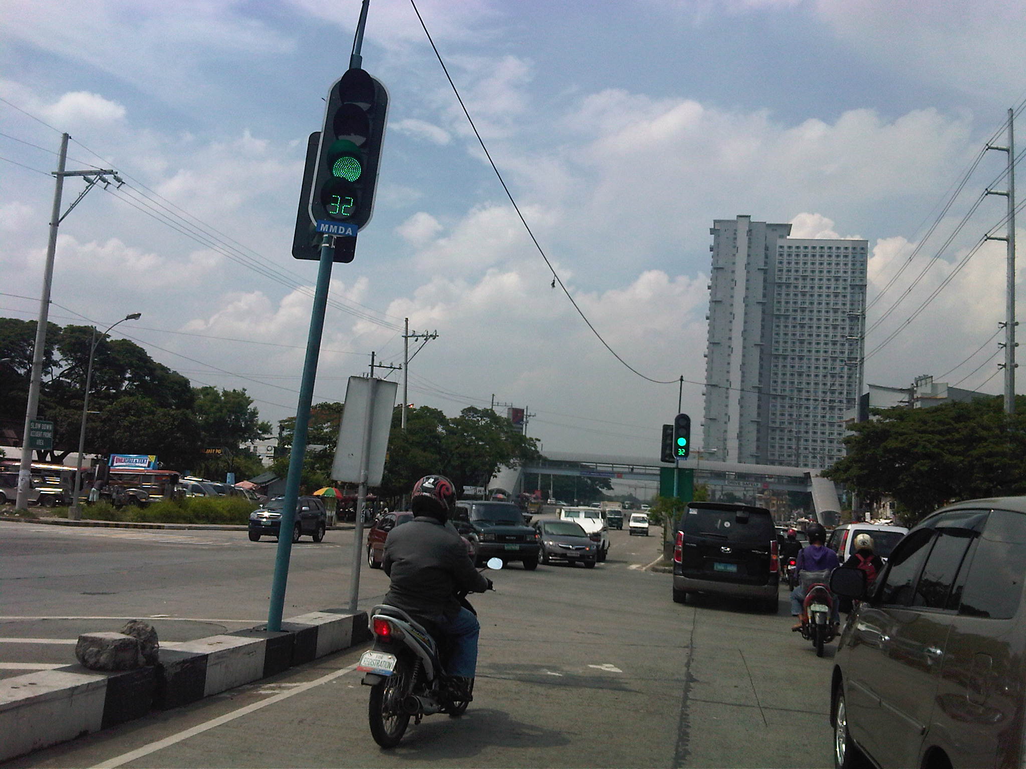
There is another innovation to traffic signals that is surely welcome to pedestrians and motorists alike but which may also have its disadvantages. I am referring to the countdown timer, which provides road users the information about the lengths of green and red signals (Note: Amber or yellow is usually fixed at 3 seconds.). From the perspective of energy efficiency, such information may allow motorists to turn off their engines, usually done when one practices eco-driving, resulting in fuel savings. Meanwhile, drivers of vehicles approaching an intersection may be able to tell if there is enough time for them to do so, and if there isn’t enough time they may be able to slow down their vehicles to stop at the next red light. Countdown timers may also be a helpful tool for enforcement as the timers establish that a driver should be aware of the time. Thus, a driver can no longer reason with the apprehending officer that he/she was not aware of the remaining time for movement.
Pedestrians may also benefit from the knowledge of available time to make a safe crossing. This information should ultimately reduce the need for running in order to completely cross the street. The photo below shows the new countdown timer installed for the southbound through movement at the Katipunan Avenue (C5) – C.P. Garcia Avenue intersection.
One possible disadvantage would be that aggressive drivers may still try to beat the red light by speeding up upon knowing what amount of time is available for them. Another disadvantage relates to beating the green light as even those unfamiliar with the signal sequence will have the information of how much time remains before they can proceed. Thus, many driver and riders start revving up their engines and push on their gears to anticipate the green signal. You can even imagine the countdown timer being used as if it were ticking towards to start of a race.
Despite the disadvantages mentioned, countdown timers should prove to be more beneficial than detrimental in most situations. In fact, countdown timers like the ones already installed at intersections in Bonifacio Global City should enhance traffic safety provided that these devices are fully complemented by enforcers who would flag down motorists and pedestrians who would attempt risky actions in relation to the timing device. Of course, from the research perspective there needs to be a scientific assessment of the actual impacts of countdown timers much like the studies already conducted elsewhere to determine and even measure the effects of these devices on both motorists and pedestrians. Only then can we truly say if they do enhance safety and promote more efficient operations at a signalized intersection.
Who’s to blame?
I first saw this report about one motorist driving his car straight into a flooded section of a street in Quezon City on GMA 7’s prime time news program 24 Oras last night. I also saw it again on New TV 11’s State of the Nation with Jessica Soho. Friends and former students have posted the video from GMA 7 as well as from YouTube. The guy blamed everyone including the MMDA, the media and the tambays in the area for not warning him about the flood. He never even thought twice about getting angry and virtually berating everyone else. Perhaps it would have served him better if he had an ounce of common sense in him that could have spared him (and his car) from the incident. Now, he is all over the net thanks to the viral video of him spreading around and showing everyone else what many of us have become. He’s practically a poster boy for citizens who do nothing except blame everyone else.
The GMA7 news report may be found here.
Traffic and flooding
Metro Manila and other cities around the country are again in the headlines because of flooding brought about by strong rains. Rains are not new to the Philippines and there are many articles (and blogs) that have been written about the history of flooding in the Philippines. Some even feature old photos or caricatures showing how life was during the Spanish and American periods when floods also occurred, probably due to similar strong rains brought about by the monsoons or by the typical typhoons that regularly visit the country during the wet season.
In those times many years ago, the subject of drainage has already been mentioned and there is evidence that certain infrastructure were constructed to address the problems of flooding. In fact, the esteros that we presently associate with informal settlers and garbage were man-made waterways that functioned as open channels that could alleviate flooding in times of heavy rains. These waterways also functioned as transport facilities as they were constructed wide enough for boats to travel along the network of esteros that also connected with the Pasig River. These were not so different as the waterways that are now being used in Bangkok that have significant commuter and even goods traffic. There are many photos of these esteros as they were back in the Spanish and American periods. There are even more recent postwar photos that allow for comparison with photos at present. Unfortunately, I cannot post these here as there may be IP issues involved. Nevertheless, one can use your preferred search engines to find and view these photos.
Through the years, however, these esteros have been neglected and, as more and more squatters came to construct their shanties above the channels and tons of garbage disposed of, they became clogged and thus resulting to flooding in many parts of Manila. The esteros, however, are not wholly to blame when the subject of floods come up every now and again. It is a fact that the drainage systems of Metro Manila and other Philippine cities are already quite antiquated and their designs cannot accommodate the amounts of rainfall experienced these days. This is the result perhaps of poor planning and even more due to the neglect of national and local governments. And so we now experience floods almost each time we have significant rainfall. In some areas, the floods do not recede until after the wet season is over. Such is the sad plight of many Filipinos who are reduced to prayers and tests of faith if only to assure themselves that things will improve – some day.
Meanwhile, other cities have engaged similar flooding problems head-on and have invested on solutions that have saved their cities from much of the costs due to damages brought about by floods. Among those cities is Kuala Lumpur in Malaysia where they constructed a tunnel that is usable as part of their drainage system as well as a highway. Kuala Lumpur’s SMART Motorway Tunnel is an example of an engineering solution that could help alleviate flooding in Metro Manila. It is quite costly, with construction amounting to about USD 514.6 million at the time of its completion in the first quarter of 2007 with construction starting about 4 years earlier in 2003. Much has been written about this infrastructure and its benefits. It has saved KL and Malaysia from potentially disastrous flooding so many times now since its opening. Was it worth it? No doubt our Malaysian friends with tell us it is and will continue to save them from more floods years from now. Thus, the cost of such projects can easily be justified and the return in investment will be quite quick given the costs of flooding that have been compiling these past years including 2009’s Ondoy (Ketsana). In fact, KL’s SMART Motorway Tunnel is part of its tollway system and was built using a public-private partnership (PPP) arrangement that is much like what the current administration is preaching.
Perhaps its not yet too late for Metro Manila and other Philippine cities? Maybe we should get our acts together in finding and contributing to solutions that also address multiple problems facing our cities in this era of climate change and extreme weather conditions.
Slippery when wet
The MMDA reported a high of 30 road crashes occurring in Metro Manila. These happened during a very wet day with heavy rains brought about by a typhoon approaching Luzon. Among the high profile crashes yesterday were one involving a bus that fell from the Skyway that cost the lives of 3 people including the driver of the bus. The other involved multiple vehicles including buses (again) and several private vehicles along the underpass section of EDSA near Ayala Avenue in Makati City.
In both cases, those involved and those investigating the incidents all cited the wet and slippery road as the probably cause of the crashes. The statements were all too familiar with drivers stating that they didn’t have enough time and space to stop because of the slippery road. Such reasoning only indicates that there is the likelihood that these drivers did not apply safe driving practices to keep their distance from vehicles ahead of them and to regulate their speeds given that wet roads offer less friction or resistance that would allow for shorter braking distances.
Despite denials, it is likely that the bus that plunged from the Skyway was speeding and that the driver lost control of the vehicle. I would like to believe that the barriers of the elevated highway were designed according to standards set by the DPWH, which are based on international standards that are incorporated in their safe design manual. Despite the standard design for the barriers, the bus still managed to penetrate it, apparently elevating once it hit the barrier.
Barriers are designed according to certain test levels that are deemed suitable for the specific facility. Such test levels that need to be satisfied incorporate elements like vehicle mass, speed, angle of impact and height of center of gravity of the vehicle (Reference: DPWH Highway Safety Design Standards, Part 1: Road Safety Design Manual, 2004). Since traffic along the Skyway consists of a significant number of heavy vehicles including trucks and buses, then the barriers should satisfy the test levels appropriate for these type of vehicles. Thus, it would be easy to check if the Skyway barrier design satisfies standards by checking the as-built specifications of the facility with the DPWH manual.
Nevertheless, speeding and not keeping a safe distance between vehicles are typically causes that may be attributed to the driver. These lead to such road crashes being categorized under driver error as their cause, which is quite justified given that perhaps there are no problems pertaining to the infrastructure/road or the vehicles involved. The weather is not really to blame since it is beyond control but road conditions may deteriorate due to rains if, for example, road drainage is not properly designed or provided. In fact, hydroplaning may occur should there be significant amounts of water on a road and becomes a hazard when vehicles travel at speeds that effectively allow water to come between the tires and the pavement. In such cases, it is also necessary to check whether the tires are able to pump out water as the vehicle runs along the road. In fact, the ridges in tires are supposed to be designed to be able to pump out water, which is the basis for tires to be also checked to make sure that they are suitable for wet roads.
Basically, all drivers should heed the message from a road sign that is provided along roads that are treacherous when the pavement is wet. “Slippery when wet” actually applies to all roads whether it be of Portland cement concrete or asphalt concrete surface, whether of good or bad condition. The mere presence of water on the road pavement presents hazards that can only be addressed if drivers practice safe driving. That is, to regulate their speeds, keep safe distances and lessen maneuvers regarded as risky even when roads are dry.

