
On weather and traffic
With the onset of the wet season, heavy rains have reminded us how terrible commuting can be especially in Metro Manila where public transport services are much wanting in terms of quality. But whether you are driving or riding, using private or public transport, there is always something about the rains that make you feel uncomfortable. Metro Manila’s roads are becoming more and more notorious for flooding and I guess that goes the same with many other roads in other cities as well. Drainage is almost automatically blamed but closer inspection of the cause of flooding shows even the newest drainage systems being unable to accommodate rain waters in part due to their being clogged (by garbage, mud and/or other stuff) or having inferior design for intense rains. With extreme weather now becoming the norm, that is not a good thing especially with what is perceived as poor maintenance of our waterways and road drainage systems. Just look at how overpasses get flooded everytime the rain pours; causing traffic congestion that could have been averted if only we can weather-proof our roads to a certain extent.
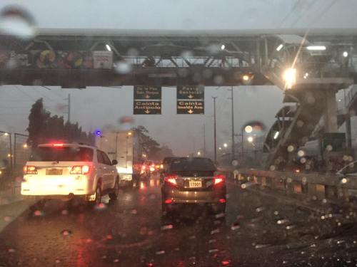
Low visibility even during the middle of the day plus slippery pavement surfaces due to heavy rains can cause congestion and lead to unsafe conditions for traveling. The latter outcome is even worse during the night and, in higher elevations, when you have fog to add to the complexity of the environment you are traveling along. Aside from travel time, nothing more serious like life or limb can be lost by practicing safe driving whenever it is raining hard. That includes slowing down, turning on your lights (for visibility) and refraining from undertaking risky maneuvers. Pedestrians and cyclists, too, need to take more caution knowing the higher risks they face or are exposed to when traveling under inclement weather conditions.
–
Mobility for persons with disabilities
I saw these two people traveling along Marcos Highway just after the intersection with Imelda Avenue. I think they came from Tahanang Walang Hagdanan in Cainta. The tricycle is actually modified to allow for a person with disability to operate the motor vehicle. The side car is also customized to carry a person on wheelchair. Note that back of the sidecar? It is actually a ramp that is locked when traveling but can be lowered for wheelchairs to roll-on or roll-off. Since there are two persons on the vehicle, the driver’s wheelchair is seen folded and loaded in front of the lady on her wheelchair.
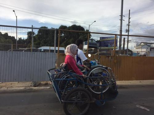
Such vehicles allow PWDs to be more mobile. Unfortunately, most public utility vehicles do not have features to allow wheelchair-bound people to ride on them. Such features may be seen in city buses in more progressive cities including those in Japan, Europe and the US. Trains can easily accommodate PWDs including those on wheelchairs as their floors are the same level as the station platforms and there is space inside the cars for PWDs. While access for PWDs is already contained in Philippine laws, there is still much to be done in terms of implementing provisions of such laws especially with respect to road-based public transportation.
–
Bicycle traffic in comparison with motorised vehicle traffic – a case in Iloilo City
I believe that there is a need to have numbers to guide planners and engineers in designing suitable bicycle facilities. It is not enough to claim there is demand since an important requirement for facilities to be provided (i.e., funded and constructed) are numbers for the facilities’ justification. You don’t build mass transit systems, for example, without a valid estimate of ridership. For one, the ridership allows for the determination of revenues. Roads cannot be built without at least a number like the population of communities that will be given accessibility via that road.
Not too long ago, we were able to obtain traffic counts for the Benign S. Aquino Avenue that is also knows as the Iloilo City Diversion Road. The road includes an exclusive bikeway constructed along its airport-bound side that is supposed to benefit cyclists and encourage more people to use bicycles for commuting within the city and between the city and towns along the national highway. The following figures show the AM and PM peak hour traffic at the intersection of the diversion road and Jalandoni Street across from SM City Iloilo. Another figure shows 16-hour traffic at the same location.
 Fig. 1 – AM peak hour traffic along the Iloilo City Diversion Road including bicycle traffic along the exclusive bikeways constructed along the airport-bound side of the highway.
 PM peak hour traffic along the Iloilo City Diversion Road including bicycle traffic along the exclusive bikeways constructed along the airport-bound side of the highway.
 16-hour traffic along the Iloilo City Diversion Road including bicycle traffic along the exclusive bikeways constructed along the airport-bound side of the highway.
The numbers clearly show the current low volume of bicycles along the bikeways in comparison to motor vehicle traffic. Since bicycles are also presumed to carry only 1 passenger per vehicle, then the volume also translates into an even lower share in terms of mode of choice by travellers/commuters. For comparison, jeepneys will likely carry an average of 14 passengers while cars may have an occupancy of 1.5 passengers per vehicle. Perhaps a more direct comparison can be made with motorcycles, which are two-wheeled vehicles like bicycles. Only, motorcycles may typically carry 2 passengers.
I am aware that at least one NGO is employing crowd-sourcing in order to obtain bicycle traffic counts along major corridors. Neither the MMDA nor the DPWH have bicycle counts with both agencies’ traffic counts only covering motorized vehicles. Few, if any, local government units would have their own bicycle traffic counts (Perhaps Marikina has data of bicycle traffic in their city that is well known for having the country’s first and most comprehensive bikeways network?). As such, there is generally a dearth of useful data for planning bikeways. One option that advocates for the “if you build it, they will come” approach is not something that is applicable to many cases especially those that do not yet require exclusive bikeways. The folly is to allocate funding for facilities that will not be utilised by their proposed users.
–
Roadworks along Sumulong Highway, Antipolo City
The roadworks along Sumulong Highway continues with drainage work along the sections across Palos Verdes and Cavalier’s Village. They have cleared a lot of trees along the road’s edge on the Masinag-bound side and only one lane is usable for these sections. This has recently caused several road crashes involving all types of vehicles. While there are obvious shortcomings about the worksite on the contractor’s side, many hardheaded drivers and riders continue to operate their vehicles (read: drive or ride recklessly) as if there are no hazards along the road.
 Concrete culverts line the Masinag-bound side of Sumulong Highway
 Worksite occupies one lane of the 4-lane/2-way highway. Temporary barriers often encroach upon the single lane available to Masina-bound traffic. This leads to many vehicles encroaching on the opposing traffic lane, violating the double line that states “no overtaking.” Perhaps the contractor needs a refresher or a lesson in proper traffic management and signage for worksites?
 Completed sections are not immediately cleared, apparently and likely to have proper curing for the concrete. Notice in the photo that the project includes sidewalk construction. Sidewalks will enhance safety for pedestrians and even joggers or hikers going up and down Antipolo.
 Notices are nailed to many trees that will be cut down to give way to highway drainage and sidewalks along the Antipolo-bound side of Sumulong Highway.
–
On cable cars as a solution to Metro Manila transportation problems
I was asked about my take on the pronouncement about cable cars being a potential solution to Metro Manila’s traffic woes. I say pronouncement because careful qualification of the news articles on this clearly show that this is not yet a proposal. I leave it to the reader to Google these articles on cable cars for Metro Manila.
The first thing that came to my mind are capacity and demand. What would be the capacity for such a system and what could be the demand given that you would have to determine where stations would be. There’s also the fear factor as many people would not be comfortable riding a vehicle so high up in the air and then of course, there’s the wind that will obviously have to be factored in the operation of such cable cars. Suitability is very much an issue here. Perhaps cable cars like the one featured in the news articles are more appropriate for cities like Baguio, Antipolo and Tagaytay? There are very limited applications for Metro Manila even including perhaps possibilities for Ortigas and perhaps Loyola Heights.
I like what my friend, Rene Santiago, said about the cable being one possible answer but not The Answer to Metro Manila’s traffic problems. I am aware of and quite amused by the comments posted on social media about the so-called ‘cable car solution’ as it is definitely not going to make a big impact on Metro Manila transport. I like comments proposing instead improved river transport as well as protected bicycle lanes around the metropolis. These are well-grounded proposals that have been proven elsewhere to be very effective in reducing congestion while mass transit projects are under construction and to be operational in 2 to 3 years time. I think it would be wiser to put your money on bike lanes and even bike bridges than in cable cars.
I was also asked about what should be the first project the new Department of Transportation Secretary Art Tugade should take on. Metro Manila is still very much a “battleground” for transport and traffic, and there are already projects lined up for implementation like the much delayed MRT 7 and the extension of LRT1. The new administration should strongly support such efforts, whether its via Public Private Partnership (PPP) or public funded. That said, I think the incoming Department of Transportation Secretary should work on an urban mass transport project in one of our major cities. Either Cebu or Davao come to mind as these cities are already also congested and would need to have an urban transit system (rail?) very soon in order to avoid becoming another Metro Manila. There are low-hanging fruits in these cities, for example, with the Cebu BRT ready to be taken on by the new administration for full implementation and Davao already being the subject of public transport studies pointing to it being ripe for a rail transit system.
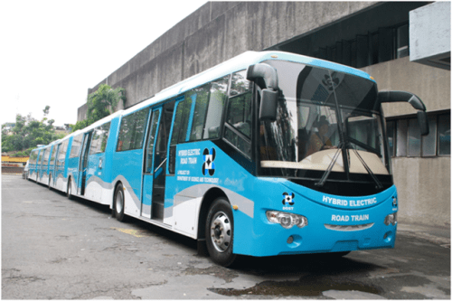
Finally, there are also the outcomes of research & development work by the Department of Science and Technology (DOST). I am referring to the DOST-MIRDC’s road train, AGT and hybrid train projects. The road trains, for example, may be used for Bus Rapid Transit (BRT) lines that are proposed for C5 and Quezon Avenue. I also think it is worth considering for EDSA. BRT is not technology-specific as far as buses go so why not use Philippine-made buses for this? While these are still subject to third party safety and technical certifications, the Transportation Department could lend a helpful hand towards this certification and this could perhaps ultimately lead to building an industry out of these buses and trains.
–
Metro Manila Skybridge: for cars or bicycles?
I was browsing over a not so old, pre-election issue of Top Gear magazine and came upon an article that featured then Senatorial candidate and already former Metro Manila Development Authority (MMDA) Chair Francis Tolentino. The article stated the former MMDA Chair’s frustration that his pet project didn’t get approval from NEDA. The Skybridge he was proposing was basically an elevated road that was to be built on top of Metro Manila rivers. This is in part to save on RROW costs and supposedly to also reduce traffic impacts of construction (note the traffic congestion due to the Skyway Stage 3 construction).
I think that such a Skybridge could have had a positive impact on traffic congestion but for a short time only. The sheer number of vehicles in Metro Manila will only lead to congestion elsewhere being transferred here and, under equilibrium conditions that will eventually be attained as some time in the near future, will ultimately be congested. The concept of tollways is for people to pay for the use of a facility in return for high level of service (read: faster travel). Skyways and other elevated highways cost a lot and the NEDA probably didn’t see a free use elevated structure like the Skybridge having much in terms of ROI.
There is, however, something that may be worth it in terms of potential congestion reduction as well as enhancement of traffic safety and quality of life – a Skybridge for bicycles and pedestrians. This should encourage people to cycle as travel via such mode will be much safer and could possibly be faster. Friends and acquaintances who are cyclists often post about similar facilities in Europe and how these are able to reduce congestion as people opt to cycle and leave their cars at home during the weekdays.
–
Addressing congestion due to school traffic congestion
There are two important traffic news stories yesterday:
- MMDA successfully clears parked vehicles outside La Salle Greenhills
- MMDA sets drop off, pick-up points for Ateneo students
For some reason that’s a bit surprising for many, the MMDA seems to have solved two of the most enduring issues on traffic congestion along two major thoroughfares. LSGH is along Ortigas Avenue while Ateneo is along Katipunan Avenue (C-5). Both have high trip generation rates and a significant percentage of their trip gen is comprised of private vehicles. While, Ateneo’s trip generation has led to traffic congestion due to the sheer number of trips the university attracts, the congestion due to La Salle is due to the poor traffic management and lack of parking spaces for vehicles attracted by the school.
I only wonder why it took so much time to address these problems considering the solutions mentioned in the articles are basically ones that could have been implemented years ago. In the case of La Salle, good old fashioned traffic enforcement apparently did the trick. But then, the MMDA even with the LGU constraint could have been stricter before whether when they were under Bayani Fernando (BF) or any of his successors as MMDA Chair. With Ateneo, the scheme is very similar if not the same as what BF proposed over a decade ago when he was MMDA Chair. At that time though a touchy issue was the U-turn scheme he installed along Katipunan that cost trees and the former service road on the west side of the avenue. We can only hope that these claimed ‘successes’ will be sustained and ensure smoother flow of traffic along the major roads they directly affect.
–
Throwback to 1995 – Baguio flyover
Baguio retains a special place in me as it is where I did my first out of town project back in 1995. This was just after I finished my master’s at UP Diliman. The project was Baguio’s first flyover or overpass and it was being proposed along Bokawkan Road, which is then as now a very busy thoroughfare connecting the city to La Trinidad, the capital town of Benguet province. Our task was to determine the best configuration for the flyover including the required capacity for it and the remain at-grade roads once it was built.
I remember it was very rainy when we were there and our accommodations (which was volunteered by our client – their family’s vacation house in the city) turned out to be quite inhospitable. We had to buy blankets and make our own beds as we had practically no budget to stay at a hotel. I recall the house was a bit creepy especially for the last few days I stayed there by myself (my mentor had to go back to Manila) to supervise the traffic surveys at the proposed site of the flyover. That was quite the adventure for me then as I also tried to explore the city on foot. I walked the entire stretch of Session Road when it was still the Session Road (old) people reminisce about. I also walked around neighborhoods in the Gen. Luna area where the house I was staying at was located.
Here are some photos of the flyover now and the area where I supervised traffic surveys together with the bridge engineer who was from Baguio.
 The flyover as seen from one of the side streets in the Trancoville district.
 A closer look at this almost 20-year structure.
 Traveling along the service road along the flyover and towards the direction of La Trinidad. Shown also in the photo is one of the pedestrian overpasses in the city. I actually like the architecture of these overpasses that seems more apt compared to Metro Manila’s steel structures.
 I included this photo past the overpass to show how crowded Baguio is already with houses having replaced trees in many mountains and hills. These used to be all green with trees back in the 1990s with only a few shanties that had started to sprout back then. I have other photos of such scenes of houses growing out of the mountains around the city and will share those in another post soon. Such have become the representation of unsustainable development for a city that has become overcrowded and yet continue to attract many people who eventually become residents.
–
Taxi stands and queues at NAIA Terminal 3
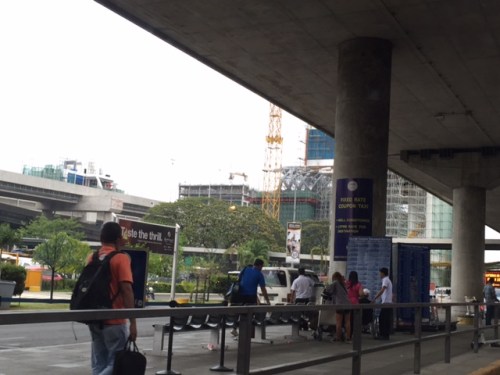
I saw a photo going around recently in social media showing the long queue for taxis at the NAIA Terminal 2. That’s actually not as bad as how the queues at Terminal 3 can be. Terminal 2 only serves Philippine Airlines’ international and trunkline (read: Cebu, Davao, Iloilo, Bacolod, etc.)flights. PAL has transferred many of its domestic flights to Terminal 3. Terminal 3 serves all the flights of Cebu Pacific plus several major international airlines that have transferred there from Terminal 1 including Delta, Cathay Pacific, Emirates and ANA. Following are a few photos of the rental car, fixed rate taxi and metered taxi stands at Terminal 3. These photos were taken last May, and still within the ‘summer’ peak period of travel in the Philippines. I was there to fetch the wife who was arriving from the US via Narita.
 Rental car booths along the island across from the arrival curb and driveway of NAIA Terminal 3.
 More rental car and limousine booths (many unmanned) just outside the arrival level. Note the car rental poster/sign affixed on one of the columns.
 Fixed rate coupon taxi stand
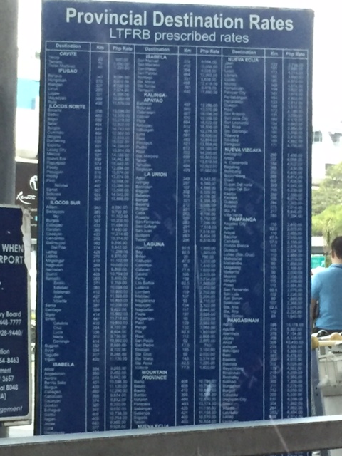 Published taxi fare rates (as approved by the LTFRB) may be found in the area. I apologise for the photo not being clear enough for my readers to see the rates.
 Long queue for the metered (regular) taxis at NAIA Terminal 3
 Metered taxi stand at the NAIA Terminal 3 arrival area
Passengers now also have the option to take the so-called premium airport bus services operated by logistics company Air21. There is also an airport shuttle service connecting NAIA’s four terminals. If staying at a hotel, people may also opt to avail of their hotel’s vehicle service. Also, Uber is now allowed to fetch people at the airport (I don’t exactly understand how authorities could know before if a car was Uber.) after being banned (duh?) from the airport.
–
On the worsening state of road safety in Metro Manila and adjoining areas
Recent days have seen some serious road crashes occurring along major roads to the east of Metro Manila. A friend posted about a crash along Marcos Highway last June 10 at the still incompletely paved Marcos Bridge. No one was killed in the crash though the driver and passengers sustained serious injuries. However, there was a high potential for this to have been a fatal crash.
 Crash involving a truck plowing into the steel fence and median of Marcos Highway near the Marcos Bridge along the eastbound direction of the highway. Both directions of the bridge’s carriageway’s asphalt overlay had been scraped off and remained neglected for several months until this morning when I observed workers laying out asphalt concrete along the eastbound lanes of the bridge.
An even more ugly crash occurred yesterday in Taytay, Rizal when a truck plowed into the tiangge are of Tatay’s public market killing scores of people and injuring more. Here is a link to some photos and videos about the Taytay crash. These two are but examples of what is happening along national and local roads all over the country with many not even being reported on mainstream or social media.
As I have mentioned in previous posts these crashes were all preventable. Truck operators and drivers need to regularly perform maintenance checks on their vehicles. Brakes are among the critical or essential parts that need to be checked especially with safety in mind. How many fatal road crashes have been reported involving brake failure? In the Marcos Bridge crash, there is also the need to make sure roads are well-maintained and projects not left out for months. In fact, poor road pavement conditions also contribute to traffic congestion as vehicles tend to slow down because of the roughness of the road (e.g., too many potholes). How can the next administration reinforce the enforcement of traffic rules and regulations as well as testing of private and public utility vehicles for these to be certified safe for driving along our roads? Will the Department of Transportation (DOT), the Department of Public Works and Highways (DPWH) and other allied agencies (e.g., LTO and LTFRB), local government units and private entities come up with a more aggressive effort to curb what seems to an increasing trend in road crashes? We hope so and look forward to positive change coming to our roads.
–
