
On the safety of transit use during the pandemic
Here is another quick share of an article that reports on a study showing that there is no direct correlation between COVID-19 and public transportation use:
editor@aashto.org (October 2, 2020) Study: No Direct Correlation Between COVID-19, Transit System Use. AASHTO Journal. https://aashtojournal.org/2020/10/02/study-no-direct-correlation-between-covid-19-transit-system-use/
Such articles and the study (there is a link in the article for the report) support the notion that public transportation can be made safe for use by commuters during the pandemic. The report is a compilation of best practices around the world that can be replicated here, for example, in order to assure the riding public that public transport (can be) is safe. Needless to say, car use is still less preferred and other findings have also supported active transport whenever applicable. This reference is both relevant and timely given the new pronouncement (or was it a proposal?) from the Philippines’ Department of Transportation (DOTr) to implement what they termed as “one seat apart” seating in public utility vehicles in order to increase the capacity of public transport in the country. The department has limited the number of road public transport vehicles and the current physical distancing requirements have reduced vehicle capacities to 20-30% of their seating capacities. It is worse for rail transit as designated spaces/seats in trains translated to capacities less than 10% of pre-lockdown numbers.
–
On sharrows
The term ‘sharrow’ basically short for shared right-of-way and refers to lanes or roads that are ‘designated’ for all modes of transport including and especially non-motorized ones such as bicycles. It also refers to the lane markings. There have been some mixed experiences and opinions about sharrows; particularly referring to whether they are effective. Here’s an article from the director of technology of Smart Design, which is a strategic design and innovation consulting firm in the US that gives another opinion (an evidence-based one) about sharrows:
Anderson, J. (September 30, 2020) “Safer with sharrows?”, World Highways, https://www.worldhighways.com/wh12/feature/safer-sharrows
I guess the experiences in different countries vary according to several factors. Perhaps these include cultural factors that also relate to human perceptions and behavior? Education is also definitely a factor here aside from awareness. And we have to work harder on these and together, rather than play the blame game on this matter that relates to safety. How many times has the observation that Filipinos tend to regard road signs and markings as merely suggestions rather than guides and regulations?
–
Pasig to Lucena vans
I was surprised to see a sign at the transport terminal of SM East Ortigas announcing van services between the mall and Lucena City (SM City Lucena terminal). This seems to be a very convenient service and it is via a route I consider to be quite scenic. This is the one via the “backdoor” of Rizal through the towns of Teresa, Morong, Tanay, Pililla in Rizal, Laguna province (Famy, Paete, Lumban, Pagsanjan, etc.) and Quezon province (Luisiana, Lucban, Tayabas).
 Modern jitneys (actually more like mini-buses)
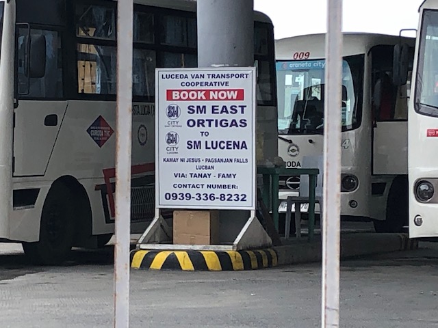 Close-up of sign showing the transport service between SM East Ortigas and SM Lucena in Quezon Province.
–
Public transport along Route 8: Cubao-Montalban
I had to go back to my usual commuting route to my workplace via Tumana as Marcos Highway is usually congested in the mornings. As such, I had the opportunity to take some photos of public transport modes along the way.
 Bus plying Route 8 – Cubao Montalban along the Marikina – San Mateo – Montalban Road (J.P. Rizal Avenue in Marikina City). Montalban is the old name of the Municipality of Rodriguez in Rizal Province.
 A Beep, a modern jitney that is actually a minibus plying to Parang-Stop & Shop route that used to be dominated by conventional jeepneys. That is, of course, a conventional tricycle on the other side of the road. By conventional I mean a motorcycle with a side car, which is the most common type of 3-wheeler in the country.
Recently, I saw G-Liner buses along Route 8. That means the bus company’s fleet is now distributed along 3 routes serving Rizal province and connecting it to Metro Manila. While, capacities are still limited due to physical distancing requirements, these buses should be able to carry a lot more passengers once the situation ‘normalizes’ so PUVs are able to maximize their seating (and standing) capacities.
–
On the transformation from car-oriented to people-oriented streets
I saw this article shared by a friend on social media and share it here as an interesting piece providing ideas and the thinking or attitude required if we are to transform our streets:
Jaffe, E. (2020) “4 ways to go from “streets for traffic” to “streets for people”, Medium, https://medium.com/sidewalk-talk/4-ways-to-go-from-streets-for-traffic-to-streets-for-people-6b196db3aabe [Last accessed: 9/30/2020]
It is actually interesting to see how this plays out in Philippine cities. The ‘honeymoon’ or ‘grace’ period from the lockdown to the ‘normalization’ (read: going back to the old normal) of traffic might just have a window and this is closing for active transport. National and local officials, for example, who seemed enthusiastic and quickly put up facilities for active transport have slowed down efforts or even stopped or reneged on their supposed commitments. The next few weeks (even months) will show us where we are really headed even as there are private sector initiatives for active transport promotion and integration.
–
What if our government officials used bicycles for their commutes?
Here’s another quick share of an article about cycling:
Reid, C. (2019) ‘Cherish The Bicycle’ Says Dutch Government — Here’s That Love In Map Form, Forbes, https://www.forbes.com/sites/carltonreid/2019/01/08/cherish-the-bicycle-says-dutch-government-and-heres-that-love-in-map-form/#2951914e2726 [Last accessed: 9/29/2020]
The Dutch have perhaps the densest bikeway network in the world as shown in the article and the link below showing bike lane maps. They also have a government that is pro-bicycle. You wonder what transportation and infrastructure would look like if our government officials biked to work or used public transport on a regular basis. Perhaps these will affect how they make policies and decisions pertaining not just to transport but on housing and health as well? It would be nice to see a counterfactual discussion or paper on this and other scenarios that could help us improve transport and quality of life. This is a big “what if” that many people are actually clamoring for so government can be grounded in the way they make plans and decisions.
Here is the link to Open Cycle Map, which is affiliated with Open Street Map:
–
References for improvements for active transportation
Here’s a nice link to a National Academies of Science, Engineering and Medicine pointing to the wealth of researches supporting improvements for active transportation:
Paths to Biking, Walking Improvements Supported by Wealth of Research
Link: https://www.nationalacademies.org/trb/blog/paths-for-walking-and-biking
The references listed should aid researchers, practitioners, advocates and policymakers in their work towards realizing a people-oriented vs car-centric transportation.
–
UN General Assembly resolution on road safety
I’m posting here the 9-page resolution on road safety of the United Nations General Assembly that was recently (August 2020) passed by the body. This is the key resolution that launched a second Decade of Action for Road Safety, 2021-2030. The document may also be downloaded from the net. Here is a link to the document via the Asia Pacific Road Safety Observatory site:


–
Social distancing on trikes
We came alongside this tuktuk-type tricycle. The model produced by Piaggio is not the motorcycle & sidecar combination that is the most common type of motorized 3-wheeler in the country. The latter currently has a one passenger limit due to the health protocols instituted in light of the pandemic. The layout of the former, however, allowed for a physical barrier in the middle of the back seat that allowed for 2 passengers for the trike.
 A peak inside a Piaggio shows the plastic barrier between passengers seated at the back of the vehicle. There is also a plastic barrier between the driver and his passengers.
Being able to carry two passengers at a time contributes to reducing the number of these vehicles required to transport people. However, most passenger tricycles function as taxis and are not in the same category as buses or jeepneys in terms of the number of people they could carry. Some cities have also taken advantage of the pandemic to reduce the number of trikes going around. In the case of Antipolo, the LGU has a program encouraging trikes to take on deliveries instead of passengers. The current passenger limit should not be used to justify more of these trikes in any city or municipality.
–
On solving the inequality problem in cities
Here is another quick share of an article that is timely and relevant not just now but for years (maybe decades?) to come:
Grossman, D. (2020) “New Study Proposes a Mathematical Solution to Big Cities’ Inequality Problem,” Inverse, https://www.inverse.com/science/a-new-study-shows-why-building-more-equal-cities-could-save-lives?link_uid=15&utm_campaign=inverse-daily-2020-09-14&utm_medium=inverse&utm_source=newsletter [Last accessed: 9/15/2020]
I will just leave it here for future reference but to summarize, the article explains how cities should be planned or replanned based on the distribution or redistribution of certain facilities like hospitals, banks, schools, supermarkets, and parks. It argues that there is an optimum location for these in relation to where people live and work. If properly planned, travel distances and times can be significantly reduced.
–
