
A quick look at the BFCT in Marikina
I went to SM Marikina recently and had my companion take some quick photos of the transport terminal project of former Marikina Mayor and MMDA Chair, now Congressman Bayani Fernando (BF). Following are some of the clearer shots as we were moving when these were taken.
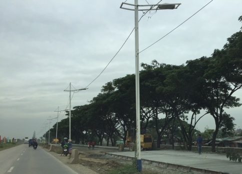
 A look at the terminal located just beneath the two overpasses connecting Marcos Highway to C-5.
 The driveway to and from the terminal lot.
 Moving towards SM Marikina under the LRT Line 2 structure, you see rows upon rows of trucks. I assume these are for sale and are there for display to prospective buyers.
 Leaving SM Marikina, this is the view of the trucks parked at the lot beneath the Marcos Highway and Line 2 bridges.
 Approach to the driveway of the terminal showing the buses currently at the BFCT.
 A closer look at the buses parked at the terminal. The green buses are RORO buses that the serve the West Philippine Nautical Highway route.
 A quick look at some of the stores at the terminal. These are mostly the sari-sari/carinderia types you see in most provincial terminals. Among the merchandise are biscuits and cookies in containers of different sizes. These are popular pasalubong for travellers to relatives and friends in their destinations.
 The sign on the right is intended for vehicles coming from C-5 that are allowed to make a U-turn near the junction with Marcos Highway to get to the terminal. This, however, takes them into direct crossing conflict with vehicles coming up from the riverbanks heading to Marcos Highway.
It would be nice to see some statistics about the number of passengers using the terminal as well as their characteristics such as origins and destinations, including transfers (e.g., how do they get to or from the terminal and what modes do they use). I suspect that there are not so many people using this terminal and the numbers will not significantly improve once the Line 2 extension is completed and the new end terminal and its environs are developed in Masinag, Antipolo City.
–
Another look at the San Juanico Bridge
We have an ongoing project with the City of Tacloban and recently we went around the northern part of the city where many relocation sites were established after the onslaught of Typhoon Yolanda (Haiyan). After doing our fieldwork, we decided to cross the San Juanico Bridge into Samar island where we were told there’s a nice restaurant sitting atop a hill in the town of Sta. Rita.
Despite the rains, we managed to get some photos of the breathtaking views. Among these were this photo of the bridge as seen from Samar. Leyte and Tacloban are behind the bridge.
 It is said that the part of the bridge on the Samar side has that distinctive ‘S’ shape while the Leyte side is a simple ‘L’ form. Trucks are weighed before they get on the bridge and the DPWH maintains a weigh station for this purpose before the Samar end. I didnt notice any from the Leyte side. Perhaps this is because most loaded trucks come via Samar rather that from Leyte?
Traffic along the San Juanico is usually light. This is despite the route being part of the eastern spine or nautical highway that is also part of the Asian Highway network. This leads me to suspect that similar (but longer and more expensive) bridges proposed for connecting other islands are unnecessary and cannot be justified when compared with other more urgent infrastructure projects including those that wil address urban congestion and promote improved mobility. The latter are more urgent and meaningful than massive structures that fewer people will use and benefit from.
–
On the other uses of ridesharing/ ridehailing services
We start 2018 with another article that I found this interesting. The article is on the other uses of ridesharing, particularly for medical emergencies:
Seipel, T. (2017) “Uber reduces ambulance usage across the country, study says”. mercurynews.com. https://www.mercurynews.com/2017/12/13/uber-reduces-ambulance-useage-in-major-u-s-cities-study-says/ (Last accessed: 12/22/2017).
This article was particularly interesting to me because we are currently doing research on ridesharing. This should be a good topic for students who are looking for something current and relevant, and should fit well in the bigger scheme of things in as far as our research agenda is concerned. There is a link to the study report in the article for those wanting to get the details on the outcomes.
–
Emphasising safety during these holidays
Here are a couple of articles that I thought should reiterate the importance of safety whenever we travel. This is especially true during this holiday season when a lot of people are going around – shopping, heading to their hometowns or simply vacationing.
Rey, A. (2017) “Holiday rush can lead to road crashes – expert”. Rappler.com. December 28, 2017. https://www.rappler.com/move-ph/issues/road-safety/192411-holiday-rush-road-crash-incident-expert?utm_source=facebook&utm_medium=social&utm_campaign=move-ph (Last accessed: 12/29/2017).
Merez, A. (2017) “Holidays heighten road accident risks: analysts”. ABS CBN News. December 28, 2017. http://news.abs-cbn.com/focus/12/28/17/holidays-heighten-road-accident-risks-analysts (Last accessed: 12/29/2017).
–
Transport safety during the holidays
I was having a late morning haircut when I overheard from the TV news reports of many road crashes occurring over the last 3 days including Christmas Day. One incident involved a jeepney that apparently veered away from its lane and crashed head-on to a provincial bus. It was ironic that the passengers of the jeepney were bound for the town of Manaoag in Pangasinan province, likely to give thanks for blessings they received in 2017 and pay homage to the Blessed Virgin whose image in Manaoag is regarded as miraculous. Not reported were the many other crashes that probably occurred all over the country over the same period but were considered minor incidents as no one perished and likely only involved property damage.
There was also an incident a few days ago involving a ferry traveling between Infanta, Quezon and Polilio Island.The ferry was carrying 251 passengers, of whom at least 5 reportedly perished. The incident again raised old but lingering issues on maritime safety including those pertaining to seaworthiness of vessels especially those plying the regular, frequent routes connecting the many islands in the country.
A lot of people travel during this season in the Philippines. Many travel to their hometowns for the typical homecomings, reunions people have during Christmas and New Year. Most trips are on the road (the mode share is dominant even considering the popularity of air travel and the sizeable number of trips on maritime transport) and the combination of road conditions, driver behaviour and other factors often lead to situations that may result in road crashes. We cannot overemphasise the importance of taking extra care when we travel, whether as a driver, a passenger or even a pedestrian walking along the road. A friend who is also an official of the transport department once gave passengers of buses advice to tell their drivers to slow down and drive more safely if and when they feel they are driving recklessly. You don’t lose lives by slowing down and driving more carefully (probably with the exception of drivers of emergency vehicles like ambulances), and this applies, too, to passengers of private vehicles who need to tell their drivers (likely relatives) to slow down or drive more safely. One does not want some joyride transform almost immediately into a nightmare much less a last trip for everyone.
Keep safe everyone!
–
Article on the need for ‘Context Cities’
Here is another good article I’ve found and read recently:
Wolfe, C.R. (2017) “Forget ‘Smart’ – We Need ‘Context Cities'”. Planetizen.com. https://www.planetizen.com/features/96310-forget-smart-we-need-context-cities (Last accessed: 12/21/2017).
Much has been said, I believe, about smart cities. I, too, have attended and even spoke (about Intelligent Transport Systems) at conferences or fora that had ‘smart cities’ as the central theme. Most talk about how technology can be used to further development and to address various transport and traffic problems. A lot of people tend to be excited when technology gets into the mix of things and yet few seem to be interested in a city seeking its true identity. And so the concept of ‘context cities’ over ‘smart cities’ become important as we need to contextualise what a city should be before we conclude that a technology push is the way to leapfrog into advancement. Perhaps the soul can be found and reconciled with and this is done through the context and not tech, which cannot replace history, heritage and culture that are distinct attributes of each city.
–
C-6 expansion and upgrading on the way…
The opening of the second Barkadahan Bridge prodded me to post something about C-6. It is a work in progress but currently you can see the progress that is quite noticeable unlike before. Here are a couple of photos we took while en route to BGC last weekend.
 Ongoing paving along C-6 for the westbound side of the highway. The photo shows recently completed PCCP slabs for 2 lanes. Forms are visible in the photo.
 Other sections have had their base compacted and ready for concrete pouring.
As a regular user of C-6 since 2014, I am one of those who look forward to the completion of its expansion and upgrading. There is also something to look forward to for cyclists and pedestrians/joggers/runners as there is a wide bikeway and segregated walkway being constructed along the side of right side of the future eastbound side of the highway. This should encourage non-motorised traffic along this corridor that directly connects Taguig, Pateros, Pasig and Taytay and extends to serve the southern part of Metro Manila, Makati City and the province of Rizal.
–
The newly opened 2nd Barkadahan Bridge
A new bridge had been under construction beside the older Barkadahan Bridge. Instead of expanding the existing bridge, the proponents decided to build another bridge likely so as to reduce disturbance of traffic along the already congested first bridge. This is the same strategy for the bridge across the Pasig River in Nagpayong/Napindan that will reduce the potential bottleneck for when C-6’s expansion is completed. Unfortunately, the bridges don’t seem to include provisions for exclusive bicycle lanes that are clearly incorporated along much of C-6.
 I took this photo as we were in queue at the approach to the intersection of Highway 2000 and the Manggagan Floodway’s East Bank Road. The new bridge can be seen here bearing eastbound traffic. The alignment at the intersection has not been addressed and so requires through traffic to basically swerve towards the entry to Highway 2000.
 Here’s the intersection and the newly opened bridge. Note the vehicles coming towards my position as they follow a trajectory from the bridge to the narrow exit leg of Highway 2000.
 Instead of a single lane along each direction, the two bridges now allow for at least 2 lanes of traffic either way. I say at least because a case can be made for 3 lanes to be indicated (there are no lane markings yet). The issue here though is that there is significant truck traffic crossing the bridge and two trucks traveling beside each other easily occupies the entire bridge. Thus, maybe a wide two lanes can be designated for both bridges with an opportunistic third lane forming depending on the traffic.
–
On car following
We teach our students about car-following theory and applications in our transportation engineering courses at the undergraduate, graduate and post-graduate levels. This is an important part of traffic flow theory and essential in understanding and modelling traffic flow/ behaviour. Among its applications is in the development of simulation models such as those that are now commercially available like VISSIM and CUBE-DynaSim and the older but still very useful TRAF-NetSim. Car-following theory allows for a more accurate simulation of real-world traffic behaviour considering the many parameters describing traffic flow as well as the assumptions that need to be in place for various scenarios.
Here’s an interesting article that’s basically about car-following, specifically mentioning the proper (ideal?) spacing between vehicles and how such discipline can lead to less congestion along our roads.
Simon, M. (2017) Math says you’re driving wrong and it’s slowing us all down, Wired, https://www.wired.com/story/math-says-youre-driving-wrong-and-its-slowing-us-all-down/?CNDID=37243643&mbid=nl_121517_daily_list3_p4 (Last accessed: 12/17/2017).
–
The need for speed (limits)?
My social media newsfeed regularly contains updates being posted by various entities about transport and traffic in Metro Manila and across the Philippines. Among those I regularly see are posts on road safety and interesting to me are the frequent posts on legislating speed limits at the local level. These are in the form of city or municipal ordinances that are supposed to strengthen, supplement and/or clarify speed limits that are actually already stated in the road design guidelines of the Department of Public Works and Highways (DPWH). These limits apply not only to national roads but to local ones as well. However, their effectiveness may be limited or reduced by the absence or lack of signs, markings and, most importantly, traffic law enforcers who are supposed to monitor traffic and apprehend those violating rules and regulations.
While there is a need for defining and clarifying speed limits perhaps in the form of local legislation, I believe the more urgent matter is the implementation and enforcement of laws. It has often been mentioned that we already have so many laws, rules, regulations and the truth is we do, and may not need more. One really has to go back to the basics in terms of enforcing these laws and that means enforcers need the knowledge and tools to be effective in their work. There is an opinion that many enforcers are not knowledgeable about many rules and regulations and therefore are prone to just focus on a few including violations of the number coding scheme, truck bans and the much maligned “swerving”. You do not often seen apprehensions for beating the red light, beating the green light (yes, there is such a violation), speeding, or “counter-flowing” (or using the opposing lane to get ahead of traffic in the correct lanes). There are also turning violations as well as those involving vehicle (busted tail lights, busted headlights, busted signal lights, obscured license plates, etc.). More recently, there are anti-drunk-driving laws that also urgently need proper implementation.
I think the current work that includes sidewalk clearing operations and anti-illegal on street parking of the Metropolitan Manila Development Authority (MMDA) is one good example of going back to the basics. These address the necessity of clearing space for both pedestrians and vehicles; space that have been constrained by obstacles that should not be there in the first place but so often have gotten the blind eye treatment. Going to the “next level” though requires tools such as speed guns, high speed cameras at intersections, and instruments for measuring blood alcohol levels in the field (breath analyzers). And these require resources for acquisitions as well as capability building in the form of training personnel to handle equipment. No, I don’t think we need more laws, rules and regulations. What we urgently if not direly need is their proper implementation to effect behavior change that will improve both safety and the flow of traffic.
–
