
Kilometer Zero
Kilometer Zero for the Philippines’ national road network is located at Rizal Park in Manila. Many people still think that this is designated at the flag pole in front of the Rizal monument at the park. The marker for kilometer zero is actually just across from the flagpole with an elegant kilometer post clearly showing it as KM 0.
 The KM 0 post in front of the another monument on the Quirino Grandstand (west) side of Rizal Park. There are many other markers in the park other than those associated with Rizal and other heroes (e.g., Gomburza). There is also a bronze statue of St. Lorenzo Ruiz (the first Philippine saint) in the middle of the grounds across from the grandstand that was dedicated by Pope John Paul II to the Filipino people to celebrate the saint’s beatification in the early 1980s when John Paul II visited the Philippines for the first time.
 Some people thought that the flagpole in front of the Rizal monument in Manila’s Rizal Park is the marker for kilometer zero. The flagpole is shown in the photo above with the Manila Hotel in the background.
 The marker up close.
–
Some setbacks for sustainable transport
There have been a few setbacks for sustainable transport in the news recently and not so recently. One is the burning of an electric vehicle, a COMET to be precise, that saw one unit burn to the ground near the UP Town Center along Katipunan Avenue. I am not aware of any official or formal findings being released as to what really happened to the vehicle but that is basically a big PR problem now as detractors of e-vehicles will point to the incident as proof that e-vehicles still have a long way to becoming a viable and safe option as public utility vehicles. E-vehicles have a lot to prove especially as an option for public transport and such setbacks only strengthen the argument against them and leaves us with the current conventional options.
Another is the discontinuance of service inside the Bonifacio Global City (BGC) of hybrid buses operated by Green Frog Transport. This one is due to what Green Frog described as exorbitant fees being charged by Bonifacio Estates Services Corp (BESC) for their buses to enter BGC. This is making the rounds of social media but there seems to be no response from BESC nor from the Bases Conversion and Development Authority (BCDA), which is supposed to also have a say with policies in BGC. Perhaps BESC thought it best to just give Green Frog the silent treatment for what appears as a trial by publicity approach by Green Frog. One commuter commented that maybe BGC authorities should push for their Fort Buses to be hybrid and phase out the jeepneys in favour of higher capacity transit inside BGC.
There have also been issue on road safety including many incidents of pedestrians getting run over by vehicles. Many of these have been captured on video particularly by the Metropolitan Manila Development Authority (MMDA), which has set-up a network of cameras in many intersections along major roads. Many show vehicles Given that many cases feature jaywalking, it is still the responsibility of any motorist to exercise caution when manoeuvring, especially when turning at intersections. Drivers will always have blind sides or weak sides when they manoeuvre so they should be very careful when in doubt and not immediately proceed when it is not clear that they have a clear path. At BGC (again) one will notice that many motorists do not give way to pedestrians even when the latter are crossing at the right locations and according to the sign clearing them to cross the street. In one case involving two speeding SUVs, one lost control and hit a pregnant woman crossing the street. While a significant number of vehicles in BGC are through traffic, it is still the responsibility of BGC’s traffic enforcers to ensure motorists follow traffic rules and regulations including prioritising safety over haste. Simply attributing such safety issues to through traffic is no excuse for traffic enforcement being as lax as or par with the rest of Metro Manila, especially for a CBD that packages itself as better than the rest of Metro Manila.
Transport Planning in the Philippines (WB, 1976)
[Important note: I have noticed that the material on this blog site has been used by certain people to further misinformation including revisionism to credit the Marcos dictatorship and put the blame on subsequent administrations (not that these also had failures of their own). This and other posts on past projects present the facts about the projects and contain minimal opinions, if any on the politics or political economy at the time and afterwards. Do your research and refrain from using the material on this page and others to promote misinformation. I suggest you go to the The Mass Transit System in Metro Manila site for more facts about railway development and history. I do not consent to the use of my articles for the purposes of misinformation and historical revisionism. 10/13/2019]
I know its been a long while since the posts on UTSMMA (1973), MMETROPLAN (1978) and other studies – past studies and plans concerning transport in Metro Manila. It seems apt that I finally was able to finish this piece in time for the Philippines Independence Day. Sinasadya talaga. I left a question hanging about what caused the changes in mindset reflected in MMETROPLAN that practically did away with the proposed mass transit network in UTSMMA. Browsing other materials at the NCTS Library, I came upon a report that I thought would have likely influenced the MMETROPLAN study team as well as government officials at the time. This is the report that I think would be the vital link between UTSMMA and MMETROPLAN – for what happened between these two studies and why the “about face” when feasibility studies were already underway for what could have been the country’s first subway line. The World Bank published a report entitled “Transport Planning in the Philippines” in 1976. The report had recommendations that were not favorable to rail transport whether for long distance or urban applications. Some excerpts are shown in the succeeding photos of pages of the document:
 Cover of the report indicating some disclaimers and restrictions to circulation. I assume that since a copy is found in a public library then it is already declassified. It is definitely a historical document and a valuable one if we are to understand transport in the Philippines and Metro Manila.
 Scan of page 36 showing the WB’s assessment of UTSMMA
 Page 37 states the conclusion of the WB report regarding UTSMMA.
I leave it up to the reader how he/she will interpret this but I think it is also important to contextualize this contents of this report to the situation of the Philippines at the time. In my opinion, too, it is basically one consultant’s word against another. From what I’ve learned, the recommended plan in UTSMMA came from a team led by a very senior and well-respected professor of the University of Tokyo’s Department of Urban Engineering. Looking back now, it seems that their work was visionary and its refuting by this WB report was a critical point in the (non)development of Metro Manila’s transport.
 A reference to LRT systems, which to some will seem like a counter-recommendation to UTSMMA
The same report suggested taking a look at LRT instead of the heavy rail recommendations of UTSMMA. This eventually led to subsequent studies seemingly having bias towards LRTs and distancing from much needed resources to improve the plight of the PNR.
 Recommendations for the long term were explicit about the importance of having a sound spatial strategy for Philippine cities.
One could only speculate what went on in the background that were off the record or not documented. Did the WB exert its influence and ‘convince’ the Philippines to shelve ambitious plans for a heavy rail network in favor of what we now know as ill-planned light rail lines? It is this same WB report that recommended for the reorganization of the then DPWTC and DPH into the DOTC and DPWH that we know today. Thus, it is not only transport policy and infrastructure influenced by this report but also institutions dealing with transport. One person’s guess is as good as another in terms of the thinking back then as there are very few people who were directly involved in planning and decision-making then who survive now and are likely willing to divulge anything that will lead us to the truth and some closure regarding what went wrong at this critical time for transport development in the Philippines.
The data and evidence points to something Marcos loyalists would cringe to admit, that the former President ultimately failed in bringing a modern public transport system to this country and its capital. [No, the LRT wasn’t as modern and progressive as they thought it to be back then. We know now that Lee Kwan Yew got it right by investing in heavy rail urban transit at that same time.] We can only speculate that perhaps the WB and those behind the scenes knew Marcos and his ilk would probably steal much of the funds that could have been allocated for the rail rapid transit system and so did their best to come up with the conclusion that it was too expensive and the Philippines couldn’t afford it. I hope my economist friends would correct me but I am leaning towards thinking that “Uutang ka na din lang, umutang ka na para sa imprastraktura na magagamit di lamang ng mga anak mo kundi pati na rin ng mga apo mo at nila.” This seems to be the basic philosophy applied by other nations that have invested much on their transportation infrastructure. Such infrastructure has already paid off many times more and are part of the backbone of strong and resilient economies.
One colleague offered the analogy that the new JICA Dream Plan for Mega Manila is actually an updated version of UTSMMA. I also believe so and it is an updated and much more validated version of what we had back in the 1970s that was at best only partly realized (the recommendations for roads were mostly implemented). However, the price for such infrastructure will not be cheap and it will only become more expensive while we procrastinate in building them. Perhaps this should be an election issue come 2016 and something that we should strongly advocate for from our leaders.
–
Finally, the LRT Line 2 Extension begins construction
The groundbreaking ceremony for the extension of the LRT Line 2 from Santolan, Pasig City to Masinag Junction in Antipolo City was held last June 9, 2015. This marks the beginning of the construction of the much anticipated and much delayed extension of the line to what was supposed to be part of the first phase of Line 2. I say supposed because most experts believe the current line should have terminated at Masinag from the start instead of at Santolan where the depot is located. Masinag had much more sense many years ago as it was a good staging point for possible extensions to Cogeo, Antipolo City proper or Marikina City. The areas along the Marcos Highway corridor beyond Masinag alone have experienced tremendous growth especially after the floods of Ondoy (Typhoon Ketsana), which submerged much of the Marikina Valley including Pasig, Cainta and lower Antipolo.
 Traffic cones and signs guide motorists away from the inner lanes of Marcos Highway.
 Two lanes from each side of Marcos Highway at the current end of the Line 2 were appropriated in addition to the median for the groundbreaking ceremony.
 The stage is set – the stage for the ceremony is set under the viaduct with these barriers practically shielding the participants from curious passers-by (usyoso). Regardless, the event cause congestion along the highway.
Of course, that was the groundbreaking ceremony. As of today, there’s no sign yet of the contractor, DMCI, fully mobilizing and already reserving the inner lanes of Marcos Highway for the construction of the viaduct and stations. If the current works for the NAIA Expressway in the airport area is to be a reference, then severe traffic congestion is to be expected along the highway and this will extend beyond the actual construction site from Santolan to Masinag. As such, the public will experience inconvenience for the next so many months or perhaps couple of years (or more if there were delays). However, I believe that once the line is operating all the way to Masinag, it will help to ultimately decongest Marcos Highway and Aurora Boulevard and a lot of people will benefit from the improved travel times.
Incidentally, the term LRT is actually a misnomer here because among the 3 operational rail mass transit lines (I am excepting the PNR Commuter Line here.) in Metro Manila, Line 2 is actually a heavy rail system. Perhaps the government should already correct this by simply referring to Line 2 as ‘LRTA Line 2’ or renaming LRTA to reflect its nature as a transit authority that should not be limited to light rail only.
–
Candidates for pedestrianisation?
I friend recently posted on the pedestrianisation of Intramuros and I commented that the walled city that used be equated to Manila should be a prime candidate for initiatives on pedestrianisation. Among the challenges, however, for any project that seeks to encourage walking by reclaiming roads and other spaces for pedestrians in the walled city would be the pedicabs. These are non-motorised three-wheelers that proliferate in Intramuros. There are just too many of these vehicles going around the area. I have mentioned these vehicles in past articles on some streets in the walled city including Calle Real del Palacio, Muralla Street, and Solana Street.
A city that can be used as a ‘good practice’ reference is Vigan City in the province of Ilocos Sur. Many parts of Vigan City are already pedestrian-friendly. In fact, Crisologo Street, which famously represents this city recognised as a UN Heritage Site is off-limits to motorised transport. However, the issue with Vigan is the proliferation of motorized tricycles. There also seems to be an oversupply of these tricycles that many continuously go around the city looking for passengers. The noise and emissions from these roaming tricycles alone contribute to negate part of the attraction of this Heritage City.
Baguio City can be transformed into a walkable city and focus should be on the iconic Session Road where small businesses including restaurants and shops once thrived. I say ‘once’ because the establishments along Session Road have experienced a decline during the past years since a major retail company constructed and started operating a huge mall near one end of Session Road. So much for the small city feel of Baguio and the local shops and restaurants that have suffered from the big business concept brought in by the mall.
In Makati City, the Ayala CBD has been pedestrian-friendly for quite some time now. People-centered facilities include underpasses for crossing major roads like Ayala Avenue and an elevated walkway connecting office buildings all the way to the Greenbelt mall. Unfortunately, these pedestrian-friendly features are limited to the CBD and
In Taguig City, the Bonifacio Global City is a good example where sidewalks are wide enough and there are pedestrian friendly malls like the High Street where people are prioritized over cars. Crossing the streets, however, can be very dangerous at BGC and traffic enforcers need to do more serious enforcing in order to manage speeds and aggressive driving by motorists in BGC. There are already incidences being shared on social media of pedestrians being hit by speeding vehicles or those whose drivers simply don’t give way especially when turning at corners.
In Quezon City, there are few areas that can be regarded as pedestrian-friendly. Among these are the University of the Philippines campus in Diliman, whose core is closed to motorised traffic during Sundays. There are initiatives for making Katipunan Avenue more pedestrian-friendly. However, these initiatives seem to be still far from being implemented on the southbound side of Katipunan where plenty of establishments do not have adequate parking and there are practically no sidewalks for people to walk on. This is the side where there used to be a service road that had to be sacrificed more than a decade ago when the MMDA got engrossed with a flawed traffic scheme.
What cities or streets would be your candidates for pedestrianisation?
Dau, Mabalacat Bus Terminal – Part 2
The first part of this feature on the Dau Bus Terminal in Mabalacat, Pampanga showed the city’s PUV Common Terminal, the bus berths from the entrance of the terminal and the many stalls lined along the terminal. This second part features more photos including some showing a tricycle terminal and an airport shuttle lounge inside the huge bus terminal.
 The interior shows an even more expansive bus terminal with more berths, a tricycle terminal and the Clark Airport shuttle station.
 Victory Liner buses berthed just after the tricycle terminal within the bus terminal
 Clark Airport Lounge in the middle of the bus terminal
 An add for a popular cracker brand states “the journey is long”
 Sign on the Clark shuttle jitney
 The Clark Airport shuttle jitney is an extended or stretched Asian Utility Vehicle (AUV) that typically seats 27 people including the driver.
 The tricycle terminal at the bus terminal allows for a more direct transfer between modes (i.e., long distance, inter-provincial or inter-city transport to local transport).
 Passengers from the lounge board the airport shuttle. Luggage are also taken inside the vehicle so it can only accommodate a limited number of people rather than the 27 I mentioned earlier.
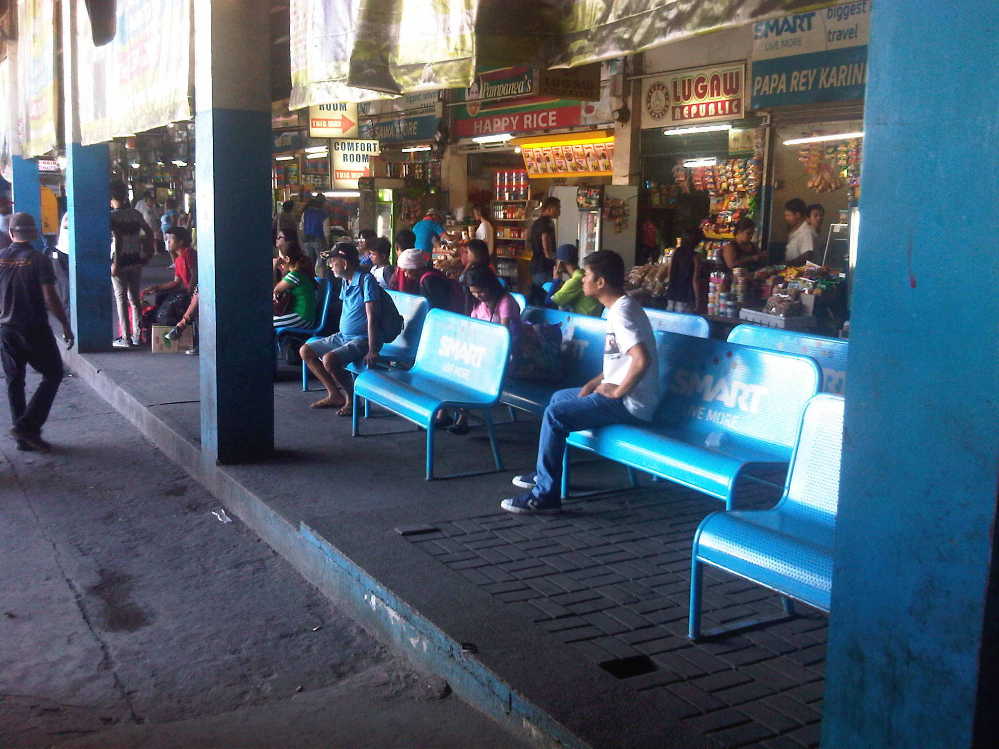 Another look at passengers waiting for their buses at the available (and limited) benches at the terminal. The benches shown seem to be ‘sponsored’ by a leading Telecom company.
 Beverage dispenser at the terminal
 Low batt? Cellular phone chargers are quite popular with passengers needing a quick battery charge while waiting for their buses to arrive at the terminal.
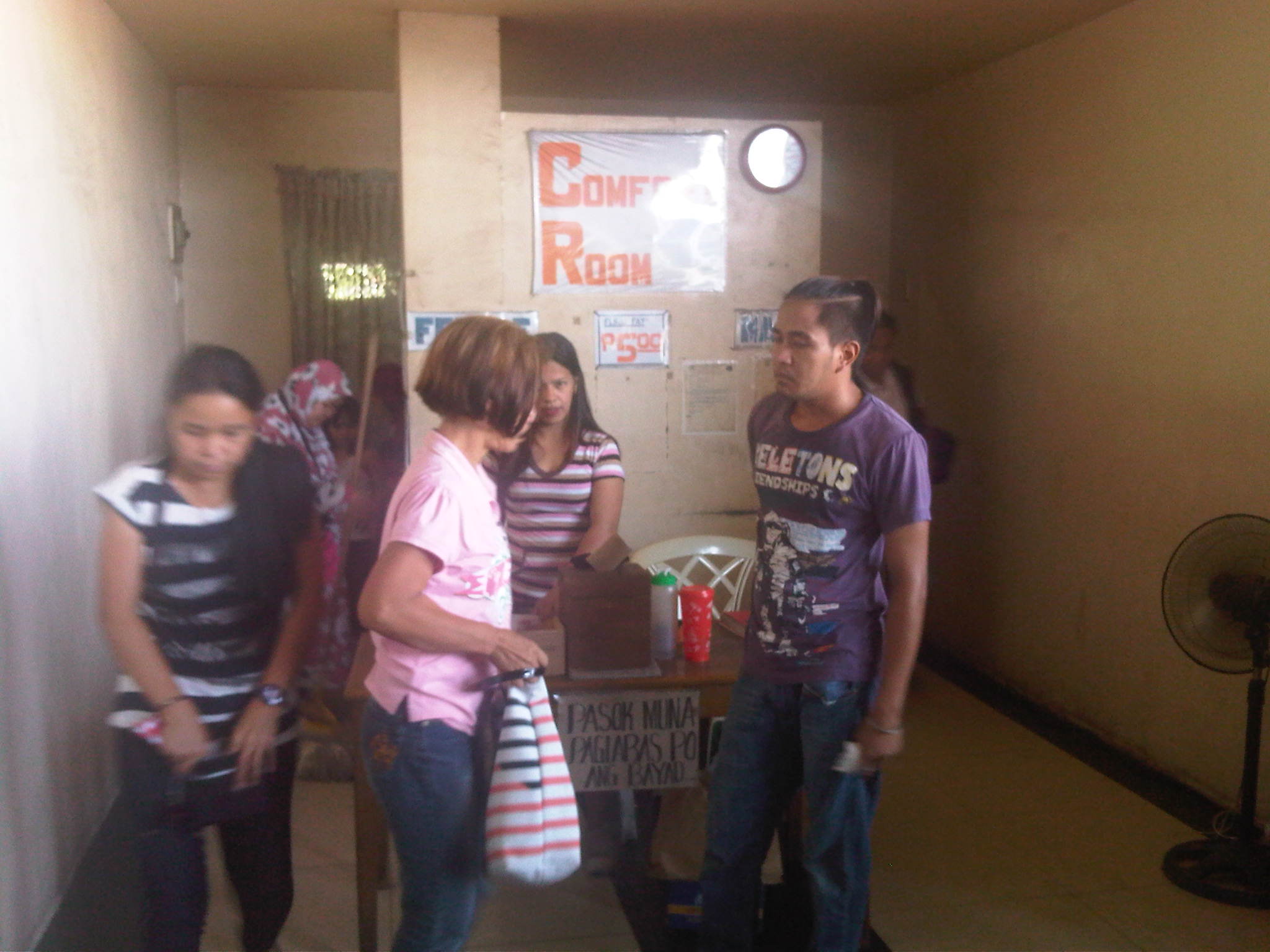 Public comfort rooms or toilets at the terminal charge 5 pesos (about 12 US cents) for each use. There’s a sign that says payments are made after use. The fees are supposed to cover maintenance of the toilets but don’t expect much in terms of cleanliness or smell.
 Passengers board a van at the Mabalacat City PUV Common Terminal. PUV stands for Public Utility Vehicle and basically stands for the vans running long distance express routes that are supposed to be non-stop or limited stop.
 Huge signboard at the entrance to the terminal
The huge bus terminal is a good example of a regional bus terminal in the Philippines and one that is also a multi-modal facility at least for road transport. It is relatively well-run and is a major transfer point for people traveling between much of Luzon Island including Metro Manila. There is definitely room for improvement including amenities for passengers and perhaps a more modern airport shuttle lounge. Perhaps there should be more investments to further improve this terminal used by so many passengers traveling mainly on the provincial buses calling on the terminal.
–
Dau, Mabalacat Bus Terminal – Part 1
We recently went to Mabalacat, Pampanga, which is north of Metro Manila and at the end of the North Luzon Expressway. The objectives of my colleagues were to inspect the Dau Bus Terminal and to look at the airport shuttle whose terminal is co-located and within the large bus terminal. Following is a first batch of photos I took at what is the largest bus (and intermodal) terminal in Central Luzon. There are others like it around the country like the one in Lucena City in Quezon Province (Southern Luzon) but few are as large and serve as many buses.
 The city’s PUV terminal is adjacent to the bus terminal
 Vans bound for various provincial destinations await their passengers at the PUV terminal. These usually seat 10 passengers and directly compete with buses for the destinations indicated in the signs.
 Passengers walk towards the terminal and the berth assigned to their buses.
 People line up to congregate at the berth assigned to specific bus companies and according to their destinations
 Passengers, well-wishers, hawkers and shopkeepers mingle in what is probably the busiest terminal in Central Luzon. I am not aware of any similar terminals in other provinces in Region 3 including Bulacan, Tarlac and Nueva Ecija.
 Stalls at the terminal sell mostly food and drinks including large containers of biscuits that are still popular pasalubong.
 Some areas of the terminal can be quite crowded as some bus companies are more popular than others.
 Not all bus companies provide benches for their passengers. Some seats are actually provided by stores and eateries but only for their customers.
 Empty berths at the bus terminal
 Passengers wait for their buses on the benches or while standing and having a quick snack or smoke at one of the stores at the terminal. The guy in the photo is actually violating a national law and local ordinance banning smoking in public areas.
 A Five Star bus arrives at the terminal. Bus companies have their assigned berths at the terminal and drivers and conductors presumably have their suki eateries or stores.
More on the Dau bus terminal in a future post.
–
Pedicabs in San Diego
I was surprised to see a familiar vehicle going around San Diego as I took a walk around the Gaslamp District. I had to do a double take as I saw three-wheeled non-motorised transport (NMT) along a busy road. Many were brightly decorated or sported lights that made them noticeable among the vehicles on the streets when it got dark. Many drivers were also dressed to attract passengers. Many wore helmets or some head gear (hats or caps for others). Motorists seem to be well-adjusted to these pedicabs running along San Diego roads but then traffic in the CBD appears to be lighter compared to downtown Los Angeles or San Francisco.
 Bicycles and cycling are very popular in San Diego so pedicabs seem to be a natural extension of that
 Three-wheeler with a smiley
 Pedicabs could carry 2 to 4 passengers depending on their seating configuration
 A pedicab decked with rope lights is followed by one with well-dressed passengers. The pedicabs were quite popular with delegates/participants of the INTA conference held at the San Diego Convention Center.
 I like this photo I took of a pedicab ferrying a passenger to the historic Sta. Fe train station. A San Diego trolley is also in the photo. The image shows the complementation among transport modes.
The pedicabs in San Diego are basically for tourism and not necessarily for commuting. They do, however, agree to carry people who would rather ride the pedicab than take a taxi or walk to their destinations. You just have to negotiate a fair price for the ride. The good thing with the pedicabs in San Diego is that their operations there provide a good example, a proof of concept if I may state, of how motorised and non-motorised options can co-exist. These options for travel include the rail-based trolley and provide people with a plethora of options for sustainable mobility. I think this should work in medium sized, highly urbanised Philippine cities as well.
–
On road crashes (again)
I was driving to work early this morning and despite today being the first day of school for public schools, I was surprised to encounter heavy traffic so early as I approached the Santolan Station of LRT Line 2. Most commuters using the station were university/college students and workers but most of the latter won’t have school until next week and it was too early (around 5:50 AM) for most workers to be at the station given that offices open either 8:00 AM (government) or 9:00 AM (private). It turned out that there was a road crash involving a large truck and a motorcycle. The motorcycle rider survived and was texting on the median island. A close look revealed that he was bloodied by the close encounter with the truck and that despite stopping, no one from the truck got down to check on the motorcycle rider. This has become a typical scene and fortunately (especially for the rider) it was not a fatal crash.
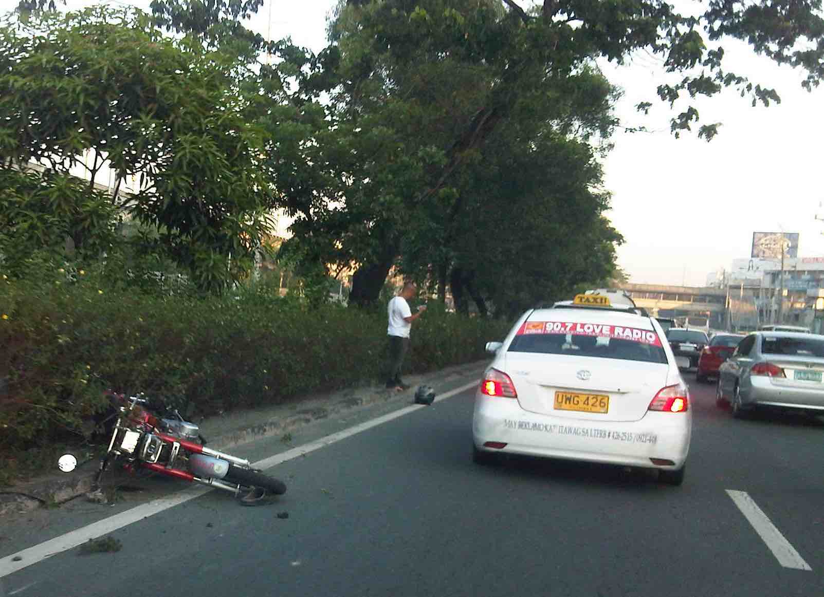 Motorcycle involved in crash with a large truck (covered by taxi in the photo).
Some quick recommendations are provided for different road users in order to avoid such situations leading to crashes:
a. For people driving large vehicles like trucks and buses: Always keep in mind that you are driving a large (and likely long) vehicle that has limitations in terms of manoeuvrability. Don’t drive as if your vehicle is a car and keep in mind that a slight mistake can lead to a fatal crash.
b. For people on motorcycles: Always ride along lanes assigned to motorcycles or refrain from aggressive weaving or lane-splitting. 2-wheelers require balance and so anything to distract the rider (e.g., using cellphones while riding) or aggressive behaviour (e.g., speeding, frequent lane changing, etc. and their combinations) lead to the high likelihood of being involved in a crash. No matter how minor these may be (e.g., dents on vehicles) the cumulative impacts are still significant in terms of costs.
c. For people driving jeepneys, UV Express and taxis: Always keep in mind that you are supposed to be driving safely as you are driving public utility vehicles carrying passengers whom you must convey safely to their destinations. This means you should exercise utmost care in driving and not doing because you simply want to earn money means you have no business providing public transport service.
d. For people driving private cars: Follow traffic rules and regulations. Common causes of traffic congestion and road crashes can be the simplest violations. The more dangerous behaviour include counter flowing, speeding and cutting (or aggressive lane changing).
e. For pedestrians: Cross at designated areas. If there are none or you choose to cross anywhere (i.e., jaywalk) make sure that you are alert and that there are clear gaps allowing for “safe” crossings.
f. For cyclists: People using bicycles should use assigned lanes whenever available. Admittedly, there is a lack or absence of bike lanes in most Philippine cities and the reality is that these will not be provided in an instant. And so cyclists should also be responsible and exercise care as they pedal along. “Sharing the road” also means cyclists need to follow road traffic rules and regulations. They are not excused, for example, from stopping at intersections when the red light is on disregarding one way streets.
With the onset of the wet season, roads will be slippery from rains and therefore add to the challenges of ensuring safe roads. We should not forget that every road user is a vulnerable person. Vulnerability is not limited to the pedestrian or cyclist though they may be the most vulnerable, often with little protection that will allow them to survive collisions with motor vehicles. Though valuable time can be lost by exercising extra care and discipline on the roads, the time cannot substitute or compensate the possible loss of life and limbs due to crashes.
–
Transfer at Narita
Our trip to the US was via Japan Airlines (JAL), which meant we had a layover at Narita International Airport where we changed planes. The stop was over three hours and so I took my time walking from our arrival gate towards our boarding gate in the satellite terminal of the airport. This was so I could get a few, ok a lot, of photos. Of course, I wasn’t able to and didn’t take photos at sensitive areas of the airport (immigration, security checks) as these areas prohibit the use of camera and cellphones.
 Passengers walk towards the terminal building upon deplaning
 Signs show the way for transfer passengers (Green) and those staying in Japan (Yellow).
 The long corridor connecting the main Terminal 2 to the satellite is quite spacious.
 There are moving walkways along one side of the connector’s right corridor.
 Information screens for Terminal 2 departures
 Example of a cafe inside the Narita terminal
 Play or lounge area for passengers along the wide bridge connecting Terminal 2 with its satellite
 Clean and elegant architecture for Narita Airport’s Terminal 2 connection with its satellite
 We really liked the “modern Asian” feel of the interior of Narita Airport
 Doorway to the satellite with signs clearly showing the way to the boarding gates
 Information screens for departing flights at Narita’s Terminal 2
 Familiar green telephones and phone card dispensers
 Our boarding gate for the Narita – San Diego leg of our trip
I will be writing a few more articles on airports in future posts.
–
