
COMET – just another jitney?
The COMET (City Optimized Managed Electric Transport) is a 20-seater vehicle designed along the lines of the jeepneys operating along many streets in Philippine cities and towns. More information on the vehicle, its operations and the organisation behind it may be found in their website. The COMET has been in experimental operation for a few weeks now but has been a rare sighting considering only 20 units are operating along a relatively long route that happens to be have congested sections depending on the time of day (e.g., Katipunan Ave. can be very congested during the day and Congressional Ave. is not necessarily a free flowing corridor given jeepney and tricycle operations along the road).
A good feature of the COMET is the GETPass, which is a card that is used to pay for fares. The card is something that should have been available many years ago and for use in most if not all transport modes (LRT, bus, jeepney, taxi, etc.). At present, it can be reloaded via COMET staff who are assigned to each vehicle or stationed at the designated stops. They help promote the transport as they sell the tap cards to passengers and other potential users of the mode. Here are photos showing the GETPass and the brochure that comes with it.
 The GETPass card comes with a brochure on the COMET and how to use the card.
 Basic information on the GETPass card.
 Illustrative example of how to use the card.
 The GETPass card
 Instructions at the back of the card.
 More information on Global Electric Transport.
 Southbound designated stops for the COMET.
 Northbound designated stops for the COMET.
 Route map included with the tap card brochure.
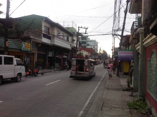
 COMET in operation along the southbound side of Katipunan Avenue (C-5).
The current experimental route of the COMET overlaps with several jeepney routes including Katipunan and Tandang Sora jeepneys. If the objective is simply to demonstrate vehicle performance (and reliability) using this route and with actual traffic conditions, then this would be a very fruitful exercise. However, more suitable routes should be considered for the COMET including possibly new routes like missionary routes or feeder routes that are not yet served by any formal public transport. This is one way for the COMET to be mainstreamed and for the low emission vehicle to have a significant impact on transport and environment. Another way that would certainly be the more challenging one is the prospect of the vehicle replacing conventional jeepneys along established routes. I say this is a challenge because there has been a need to retire or phase out conventional jeepneys in favor of higher capacity modes (i.e., bus) and the jeepney sector (operators and drivers) have always been somewhat averse to proposals modernizing jeepneys due in part to financial implications of transitioning to low emission options like the e-jeepney or the COMET. If these are not considered, the COMET will just be an additional vehicle along Metro Manila’s streets, contributing to the chaotic road public transport, and its hyped benefits will not be realised.
I do hope that the COMET will not be just another paratransit mode that is integrated with all the other land transport modes currently in operation throughout the country. I believe there is a big potential for the vehicle and similar other models like it for cities and towns that are not yet as highly urbanized as Metro Manila or perhaps Cebu. There are corridors or areas where buses are not or will not be viable within the foreseeable future (next 5 to 10 years?) given the demand for this period. These are where jeepneys thrive (assuming tricycle operations are restricted or strictly regulated) and where the COMET would be most suitable.
–
Interesting articles on traffic congestion
Here are a few good reads on traffic congestion and its measurement or quantification:
- How Not To Measure Traffic Congestion—Hold the Hyperbole, Please! which appears on Planetizen today, October 15, 2014.
- Rethinking the economics of traffic congestion which appeared on June 1, 2012.
Reading these articles will probably make you think that traffic is good or that congestion is good. While congestion is indeed indicative of economic vibrance as movement of people and goods are a good measure for economic activity, excessive congestion results in many other problems that need to be addressed and which can also be quantified in economic terms. Note, too, that one author mentions “peak traffic” that is now becoming common in developed countries as motorization has plateaued and transport systems have become developed to provide people and goods with a variety of modes to choose from including walking and cycling. In our case, traffic has not yet “peaked” in the sense that motorization continues for many of our cities including Metro Manila. There is also a lag in the provision of transport infrastructure including mass transit systems that should have been constructed decades if not years ago. Perhaps we need to be clear about the context by which congestion costs are estimated and presented.
The somewhat dramatic presentations like the manner shown in the first article above reminds us of similar estimates of congestion costs in the Philippines, particularly for Metro Manila. The latest of these come from a JICA project that had as an objective the drafting of a roadmap for transport in the expanded region that is dubbed as Mega Manila (Region 3, National Capital Region and Region 4A). The end product has been billed as a “Dream Plan for Mega Manila” and draws on congestion cost estimates that would definitely be regarded as exaggerated if seen in the context of the two articles we mentioned above. Perhaps it is the important message (i.e., we need to build transport infrastructure) of such exaggerated presentations that we should focus on an not really the specific numbers being quoted by news organizations and circulated in social media.
We have to caution the reader that congestion is here to stay and cannot be totally eliminated, especially with economically vibrant or growing cities. What we probably would like to address, however, is excessive congestion. Yes, there is such a thing as excessive congestion. I would like to describe this as something that is “unreasonable” along the lines of say instead of your regular 1 hour commute, it took you 2 hours or more. For some, this can be due to horrendous traffic jams due to flooded streets. Or perhaps someone who takes public transport waiting for hours just to get a ride. And so people are forced to cope and in a way, their minds have been conditioned to tolerate (accept?) the levels of congestion they experience on a daily basis. Congestion is good but it does not have to be hellish.
–
Metro Manila Urban Transport Improvement Project (MMUTIP, 1981)
[Important note: I have noticed that the material on this blog site has been used by certain people to further misinformation including revisionism to credit the Marcos dictatorship and put the blame on subsequent administrations (not that these also had failures of their own). This and other posts on past projects present the facts about the projects and contain minimal opinions, if any on the politics or political economy at the time and afterwards. Do your research and refrain from using the material on this page and others to promote misinformation. I suggest you go to the The Mass Transit System in Metro Manila site for more facts about railway development and history. I do not consent to the use of my articles for the purposes of misinformation and historical revisionism. 10/13/2019]
We continue with our historical features on transport with the Metro Manila Urban Transport Improvement Project (MMUTIP). MMUTIP was implemented from July 1980 to August 1981 with funding from the Overseas Economic Cooperation Fund (OECF) of Japan. MMUTIP recommended for a new franchising system to be adopted by the then Board of Transportation (BOT), with standards covering citizenship, route opening, operating performance and financial capability. It also called for the adoption of measures that will safeguard the integrity of franchise records and the speedy processing and better control of franchise applications. The BOT is the precursor of the Land Transportation Franchising and Regulatory Board (LTFRB).
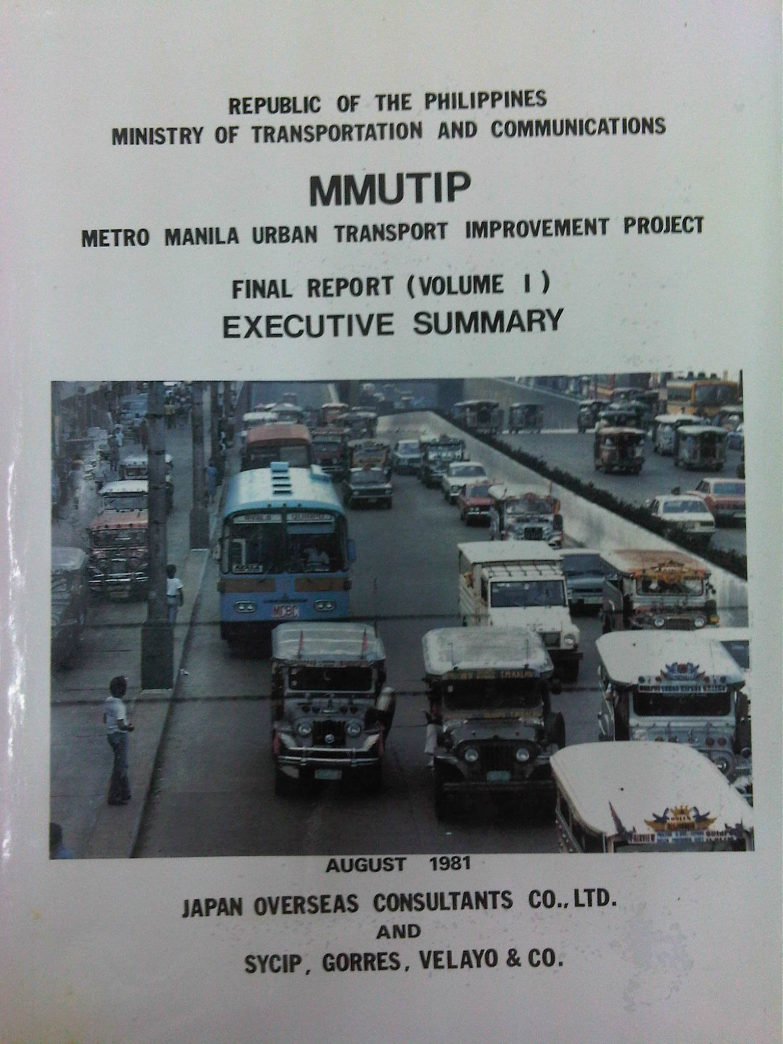
Additional bus routes were identified by the study and recommended for 5,900 units for daily operations. The study estimated that as much as 1,870 additional units were required for Metro Manila. Meanwhile, the study found the operations of the Metro Manila Transit Corporation (MMTC), the government owned bus company, unprofitable and stated that the government-run company has failed to define objectives and policies particularly in specifying the extent to which MMTC will render public service at the sacrifice of profit (note that MMTC was losing money in part because it was serving missionary routes so as to reduce direct competition with the private companies). I think looking back now, this was perhaps the beginning of the end for MMTC. Some people say that we could probably have used something like the MMTC today to keep public transport operators honest in their operations and also to continue providing services for missionary routes rather than letting these be served by tricycles and jeepneys that will eventually would have to be granted franchises. As it is, such situations often lead to poorly planned transport services including the (mis)determination of the number of PUV units required to serve an area or corridor.
MMUTIP recommended for the control of entry and operation of jeepneys along major bus routes while at the same time calling for a deregulation of entry and operations outside major thoroughfares, which were served or are more suitable for buses. Further, the study called for encouraging tricycle services where bus and jeepney routes are scarce while also stating that these should be limited to local or feeder services. Then as now, tricycles are restricted from national roads.
[Note: A copy of MMUTIP may be found at the National Center for Transportation Studies (NCTS) Library located at their building along Apacible Street at the University of the Philippines Diliman. This is not a public library so access is limited to UP staff and students. Researchers and others from outside UP would have to write to the Director for permission to use the library and its holdings.]
–
Sta. Lourdes Wharf – Puerto Princesa City
The jump-off point to island hopping in Honda Bay is Sta. Lourdes Wharf just north of Puerto Princesa City proper. I have seen this wharf evolve into the modern (compared to other Philippine wharves or ports) facility that it is now. I guess this is possible if both national and local government really put the necessary resources to improve such infrastructure that obviously benefits everyone and not just the tourists who happen to flock to this port for island-hopping trips.
 The local tourism office and amenities like toilets are housed in this building. What it used to be was a building made out of bamboo with nipa and a few iron sheets for roofing. Boats were moored just behind the building in what looked like a chaotic set-up for tourists and islanders. There was no concrete road 5 years ago and the dirt road was a muddy mess during the wet season.
 Philippine Coast Guard station at the wharf
 Outriggers carrying passengers; mostly tourists on the Honda Bay island hopping package
 This larger boat is not necessarily for tourists but for ferrying passengers between the mainland and the smaller islands off Palawan. It is obviously of sturdier design and has a bigger passenger capacity.
 Our outrigger waiting for us to board. The crew consisted of two boatmen – one handling the motor and driving the boat while another was in-charge of handling the line, anchor and maneuvering the boat from the port and towards the sea (with just a bamboo pole as a tool).
 A snapshot of other boats docked along the wharf shows mostly outriggers. In the background at about right is a glimpse of a Philippine National Police fast craft. The PNP has a maritime unit complementing the Philippine Coast Guard and those stationed in Palawan have modern fast craft capable of giving chase to pouchers and pirates in their speedy boats.
 A Chinese boat moored at the PNP dock. This fishing boat was intercepted by Philippine authorities illegally fishing in Philippine waters. This was the subject of well-circulated news reports showing the Chinese were catching endangered species like sea turtles and were carrying live and dead pangolins and other wildlife they were smuggling out of Palawan (with the help of shady Filipinos, of course).
I think the Sta. Lourdes Wharf is a good example of adequate port facilities serving both passengers (including tourists) and goods. It provides for the basic needs of users though there is usually some congestion at the port due to increasing tourism activities. The wharf practically becomes a parking lot to tourist vehicles during certain times of the day and this becomes serious during the peak tourism months. This, however, is a minor concern for now. Access to the wharf is also excellent with good quality concrete roads from the city centre to the wharf; a combination of national and local roads being developed to a standard that makes them “all-weather” and comfortable for use by travellers using all types of vehicles. This is something that can and should be replicated for similar ports around the country not just for tourism areas but basically to address the needs of travellers and goods.
–
Bad P.R. for road sharing
A few articles came out of Sun Star Cebu recently regarding an activity over the weekend that was supposed to promote road sharing. I read four articles by different opinion writers. These may be found in the following links:
- A crazy exercise [Bobby Nalzaro, September 28, 2014]
- Sharing narrow roads [Opinion, September 29, 2014]
- Road sharing, road rage [Eddie Barrita, September 30, 2014]
- Green Loop’s faulty premises [Bong Wenceslao, September 30, 2014]
The first three articles seem to be more like reactions of motorists to activities that seek to promote road sharing and cycling in particular. The writers missed the point in so far as road sharing is concerned and are definitely biased towards the status quo in terms of road usage. However, some of their observations need to be qualified as certain roads seem to have been closed with little advise to the general public, many of whom take public transport. The last article is the more grounded one and explains the perspective of non-bikers who are public transport users. This is the calmer opinion among the four and expresses his points in a more objective manner.
I was not there and I haven’t read yet any articles from the organizers or participants to the activity. I would like to give them the benefit of the doubt in so far as their advocacy is concerned. But then one also has to consider the valid points raised by other road users whenever road sharing is equated to cycling rather than a more balanced mix that is focused towards maximising the number of people or amount of goods transported. It is not only a question of space but of efficiency of movement. Bicycles might be efficient in energy but unfortunately it is not the most efficient in terms of the number of people carried between origins and destinations. And we can never decongest our streets in order to make more space for cyclists and pedestrians if we cannot come up with efficient public transport systems that will encourage people to leave their cars or not to buy one in the first place. It can be argued that people are actually opting for motorcycles than bicycles for commuting – another trend that needs to be understood from the perspective of people making these choices for their transport needs.
–
NAIA Terminal 3 multi-level parking
The multi-level parking facility of NAIA Terminal 3 is open. I have not been to T3 in a while and saw that the multi-level parking was operational only upon returning from a trip to Palawan last week. Last night, as I maneuvered to the open parking lot prior to fetching a friend at the airport, I was directed by airport security to the multi-level facility upon being informed that the open parking lot was already full. Following are a few photos of the multi-level parking at NAIA Terminal 3.
 The entrance and exit to the multi-level parking facility is at the end of the arrival level driveway.
 Motorists should keep to the right heading towards the parking building. There are two lanes clearly marked for the entrance.
 There are two booths but there is currently a desk where staff issue parking tickets to users.
 Driving inside the facility, one realises that it is spacious and could handle the vehicles generated by the additional flights begin served by T3.
 Not many people seem to be aware that the parking building is now operational based on the many spaces still available around the multi-level facility. Most people still use the open lot across from the terminal unless its closed off (full) and security staff direct them to the parking building.
 Most driveways are 2-way and so provides good traffic circulation inside the facility.
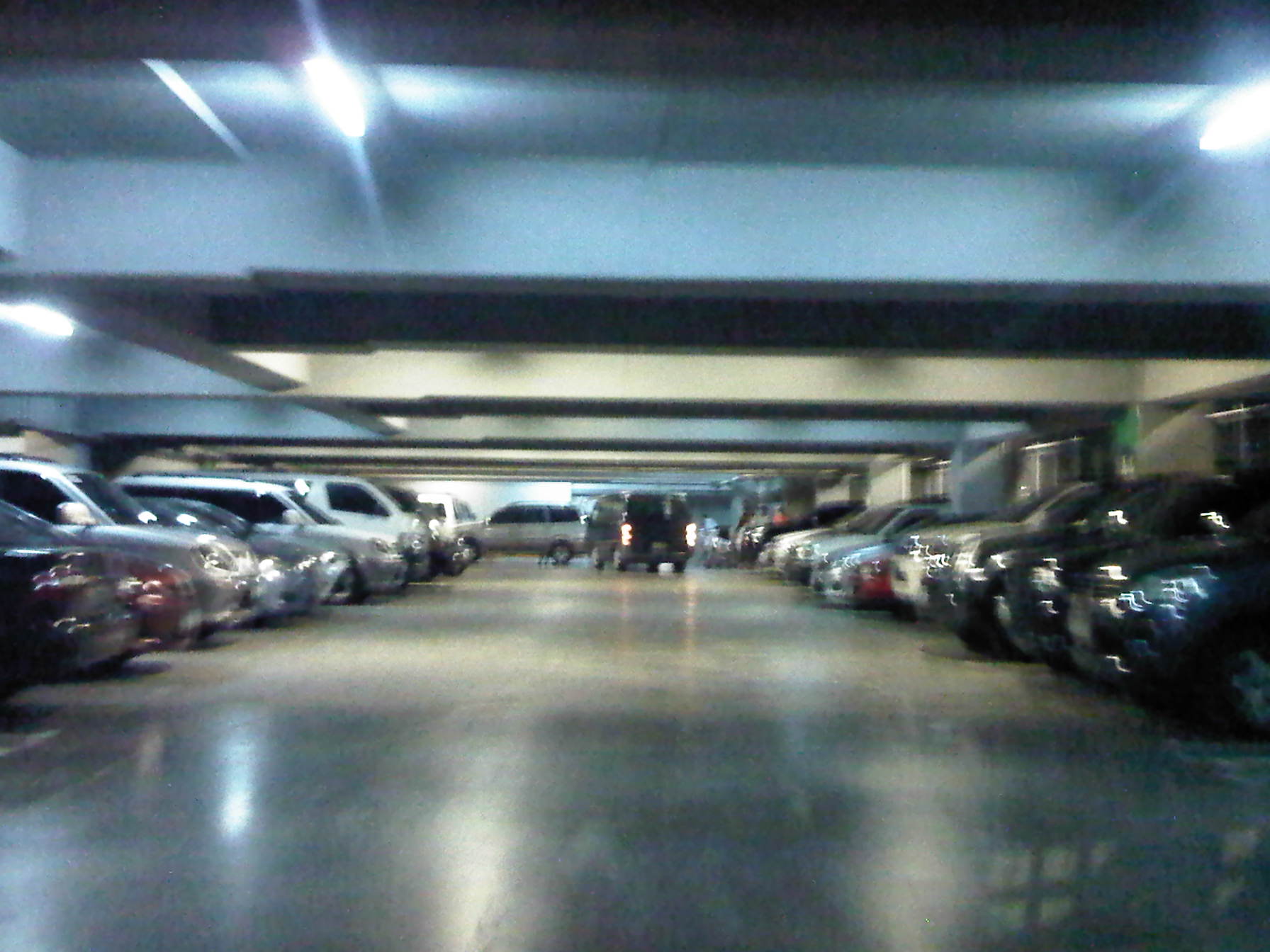 The spaces nearest to the entrance to the terminal are obviously the first ones occupied.
While it took some time for authorities to finally open the multi-level parking at T3, it is a most welcome development considering many international airlines have been transferring operations to T3. These include Cathay Pacific, Delta, Emirates, Japan Airlines and Singapore Airlines among others that will be using T3 as T1 is being rehabilitated. The rates are the same as the open lot (I paid PHP 40.oo for almost 3 hours parking.) and because your vehicle will be basically indoors, it is a good option for trips where you opt to leave your car at the airport (park & fly). NAIA charges PHP 200 per night but I think this is a very reasonable rate assuming that this is a more secure facility compared to the open lot.
–
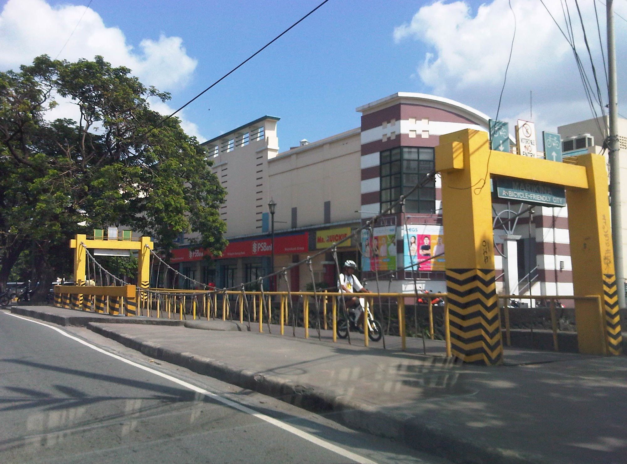
Let’s revisit the Marikina Bikeways
Calls for more walkable and bicycle-friendly cities and a lack of local data for these modes of transport got me thinking about Marikina. The city has its own bikeways office, the Marikina City Bikeways Office (MCBO), that was under City Planning and Development Office but borrowed staff from other offices of the city. The MCBO has gone through many challenges since the time of Bayani Fernando, who instituted the office, and his wife Ma. Lourdes under whose terms the office was downgraded. I’ve learned that the office has been strengthened recently and is implementing a few programs to promote cycling especially among school children. I wonder, though, if Marikina has been collecting and keeping tabs on cycling related data. I recall that during the conduct of the study for the Marikina bikeways network, it was established that there was a dearth of data on cycling and data collected pointed to cyclists primarily comprised of workers in factories or construction sites in the city and neighbouring areas. These are the regular commuters using bicycles instead of motorised vehicles. It would be nice to see if these increased in numbers (observations along major roads like Sumulong Highway seems to support the increase) and if there have also been shifts to motorcycles as the latter became more affordable in recent years. Enforcement is still an issue with regards to the bikeways as not all paths are segregated. As such, those lanes painted on the roads are more susceptible to encroachment by motorised vehicles. Still, Marikina is a very good example of realising people-friendly infrastructure and many LGUs could learn from the city’s experiences with the bikeways.
 A bicycle bridge along Sumulong Highway in Marikina City
Recently, some students consulted about designing bikeways in other cities as well as in a bike sharing program being planned for the University of the Philippines Diliman campus. These are good indicators of the interest in cycling that includes what discussions on the design of cycling facilities and programs intended to promote bicycle use especially among young people. We strongly recommended for them to check out Marikina to see the variety of treatments for bikeways as well as the examples for ordinances that support and promote cycling.
–
Flooded roads and some thoughts on flooding
I’ve always said that transport and traffic problems will always take a back seat to flooding. Traffic also takes a back seat to floods in this post. Issues like congestion and terrible public transport services are experienced by many everyday but basically do not stop people from their routines. Floods on the other hand are a major inconvenience that makes things like congestion or getting a ride during the rush hours much worse. Floods also have a way of making things stop as people cannot go to work and students cannot go to school. It seems that whenever there are floods, everything grinds to a halt and productivity takes a dive. Such losses, of course, are in addition to the cost of damages directly brought about by the floods.
The following photo was taken by a staff of our office who was going around near his home. Fortunately, their place was not flooded so that afforded him time to go around and take some photos of the swollen Marikina River along Marcos Highway in the Pasig-Marikina border.
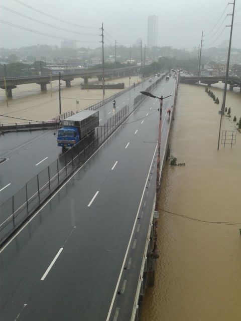 Marcos Highway Bridge over a swollen Marikina River – not visible in the photo is the road leading to FVR Road and C-5, which is usually subject to flooding. The tall building in the background is SMDC’s Blue condominium along Katipunan Avenue. [Photo credit: Roy Velasco, NCTS, September 2014]
These extreme floods have been happening more frequently lately. I think these extreme rain events brought about by typhoons or monsoons are the norm now and we should be more prepared than ever in dealing with such heavy rainfall. Flooding can be alleviated if not eliminated and the experiences of some flood-prone LGUs can help us in determining suitable approaches to alleviate the problem and mitigate its impacts.
The philosophy applied by previous administrations of Marikina City did not have the objective of eliminating flooding. That was too expensive for a growing city that needed to put resources to other aspects or areas of development. The main objective was to alleviate flooding; mainly to reduce the depth as well as the duration of flooding. That is, instead of having waste-deep waters, perhaps knee-deep would be more tolerable. And instead of having to deal with flooded homes or streets over a day or more, half a day would make life better for people affected. The key was to address issues that led to severe flooding. Such issues include poor drainage stemming from inadequate maintenance of facilities and the still tremendous amounts of garbage irresponsibly disposed off by people, especially those living near waterways.
Marikina, Antipolo and Cainta at least should consider building retention basins in order to mitigate serious flooding. A lot of waterways were lost as residential subdivisions were developed and developers responsible for these should bear part of the burden by doing their part (e.g., identifying and turning over or donating lands than can serve as sites for the basins) in helping alleviate flooding. One friend pointed out that the critical time for flooding would be when rains are heaviest (e.g., last Thursday to Friday for Mario or the 6 hours of extreme rains by Ondoy in 2009). Basins should be designed so they can accommodate waters from the rains during the critical period so that instead of neck-deep floods, perhaps there will only be knee-deep or waist-deep waters. Yes, there will still be floods but they will be more tolerable and perhaps faster to dissipate than when you don’t have the basins to mitigate such events. There will be significant costs for such facilities but then the costs surely don’t compare to the annual losses that can be attributed to flooding and relocating whole communities definitely is much more costly and is not an option for those in the Marikina Valley and other food prone areas. Floods have been issues for many LGUs during elections and whoever can come up with a good plan to alleviate flooding will surely win a lot of votes.
–
Streets of Malabon
I happened to be in Malabon one weekend for a get-together with the wife’s relatives who lived in the area. Malabon is an old town that is often mentioned in history books (i.e., during the Spanish period). Though the name of the town is said to have been derived from the term “ma-labong,” which is short for “maraming labong” or plenty of bamboo shoots, it is likely, too, the place was named after San Francisco de Malabon. Here are a few photos we managed to take as we drove along Malabon’s streets. I was not familiar with the area but Waze and Google maps provided ample information for us to navigate our way around.
 Gen. Luna Street in the Malabon city proper is a one way street. Other streets in the CBD have also been designated as one-way streets as all (and not just a few or most) roads are narrow.
 Non-motorized transport are popular in Malabon and you will see a lot of bicycles and pedicabs along the streets. These are usually in mixed traffic and seem to blend quite well with motorized vehicles. This seems to be a good example of practicable road sharing.
 While the streets are designated one-way for motor vehicles, bicycles and pedicabs generally travel counterflow and oblivious to the risks of doing so. Still, motorists seem to be okay with this and traffic enforcers do not mind the practice.
 There are many people using bicycles and pedicabs in Malabon. Noticeable are the unique designs of sidecars as the bicycles used in the trikes are taller than the usual bikes elsewhere.
 One of the narrow side streets in Malabon. I think these should only be used for walking or cycling and motor vehicles (including motorcycles) should not be allowed to use these. Malabon can be developed as a walkable city and since it has narrow streets, traffic circulation needs take into consideration how to effectively use one way scheme or combinations in the network.
Malabon is a flood-prone area. Combined with its narrow streets, the area needs an all weather transport system. Non-motorized transport like bicycles and pedicabs can provide this as well as buses perhaps, though the narrow streets and tight turns at intersections can definitely be tricky for large vehicles. It would be interesting how the city will continue to develop considering the constraints. The town proper itself is challenged in terms of the area available for development and perennial flooding will always be an issue that will be quite difficult to overcome. Still, the city and its citizens persist and have been able to overcome these challenges. It can only be hoped that the city will continue to thrive amidst the challenges.
–
Lane discipline
Among many peoples’ pet peeves in traffic would probably be the propensity for lane changing among many drivers and riders. This is especially true for wide multi-lane roads like Commonwealth Ave., Marcos Highway and EDSA. While it can be an understandable behaviour for free flowing traffic along long stretches where weaving can be executed safely, lane changes can be quite risky at intersections and may instantly lead to crashes. These are likely the bases for the swerving violations that the MMDA and other traffic enforcers became notorious for issuing for a time.
We chanced upon a scene at the Commonwealth Ave.-Mindanao Ave. intersection in Novaliches where a car seemed to have attempted to cut in front of a bus in order to make a turn but got hit by the bus. From the angle of the collision, it appears that the driver of the car likely maneuvered for a U-turn and made the critical assumption that he could beat the bus for the turn. It was obvious that the bus was in the right position while the car was not. This is often the case for drivers who do not care for positioning themselves along the correct lanes at intersections and seem to rely on their guile to get ahead of others. Such drivers might just be the same ones who would likely do counter-flows also to get ahead of others queued along the right traffic lanes.
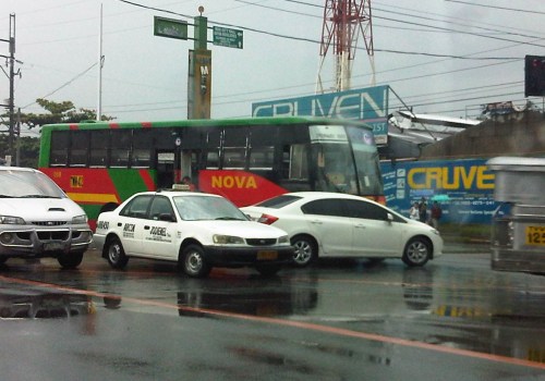 White car attempts to make a U-turn right in front of a bus and gets hit by the bus whose driver likely did not notice the white car sneaking in front of the vehicle.
Lane discipline becomes more important with the revival of traffic signals all around Metro Manila. In addition, it is also important for the appropriate lane markings to be placed at intersection approaches. Such markings are supposed to guide drivers where they should position themselves so that they will not block traffic going in another direction. These can also aid in the enforcement of lane discipline as vehicles on the wrong lanes can be apprehended. This was the case in Cebu City in the 1990s when the city adopted the SCATS traffic signal system, which employed detectors embedded on the pavement along the approaches to intersections. These detectors helped determine whether there is demand for a particular movement (left, through or right) and so requires lane discipline for the system to work effectively. –
