
On runway configuration and orientation
We teach our students the basics of Airport Engineering including design principles for airside and landside facilities. The most important airside facility is the runway and there are several factors affecting the determination of runway configuration and orientation. Even for single runways, these factors are critical in order to ensure safe and efficient operations. Factors affecting runway configuration and orientation include:
1) Wind – the direction and magnitude of the wind is critical for aircraft as headwinds help generate the lift required for taking-off and cushioning landings. Headwinds will tend to shorten runway length requirements due to this assistance with lift while tailwinds will tend to increase runway length requirements. Cross winds are undesirable as they may cause aircraft to roll or stall. A useful tool for establishing wind behavior (e.g., directions and speeds) is a wind rose, which requires many years of data on wind speeds along different directions to establish the best orientation for a runway. The wind rose pretty much looks like a spider graph overlaid unto a compass, illustrating along which directions the winds are strongest. Wind roses may also be constructed according to the times of the year to account for seasonality in the information.
2) Neighboring airports and airways – one can just imagine the nightmarish situations faced daily by air traffic controllers in New York where there are several major airports not just in that city but in nearby metropolitan areas as well such as New Jersey, Philadelphia and Washington, D.C. where hundreds of flights converge in what is very limited airspace. Thus, air traffic controllers would have to be mindful of the shared air space among planes operating out of the different airports in providing guidance to pilots taking off or maneuvering for a landing.
3) Obstructions – these refer to possible obstructions around the airport and particularly along the flight paths of aircraft and imaginary surfaces are drawn with respect to the proposed runway configuration to determine the height restrictions for structures and other features around the airport. These imaginary surfaces include the projection of aircraft approaches from either end of a runway (or runways) that logically should be free from any obstructions. Cities are required to strictly enforce land use regulations around an airport to ensure safety.
4) Topography – the presence of mountains or bodies of water will influence how an airport will be laid out including considerations for future development or expansion. In many cases, mountains will influence other factors such as wind and obstructions. In certain areas, airports are built over plateaus, thereby restricting development options from the start. Examples of these in the Philippines are Baguio’s and Cagayan De Oro’s airports that are also affected by fog, adding to the challenges (and hazards) faced by pilots.
5) Restricted areas – there are certain “no fly” zones in cities such as the airspace directly above sensitive areas or buildings like military camps or the official residences of heads of state/government (e.g., Malacanang, the White House, etc.) are enforced as a matter of security.
6) Bird hazards – there have been an increasing incidence of bird strikes reported in the local news with many attributed to the increase in numbers of migratory birds. These pose hazards to aircraft (even the large jetliners) as the birds can get sucked by their engines resulting to damage to the propellers or fan jets. As such, many airports employ staff to ward off birds or use devices to disperse them. These efforts, however, are limited to the airport grounds. Beyond the airport, birds, particularly those in protected areas may still pose dangers to aircraft should the areas be along the aircraft flight paths.
7) Control tower visibility – air traffic control provides guidance for aircraft operations whether they be on the ground or in the air. While there are modern, hi-tech instruments available in most large or major airports, safety and guidance is greatly enhanced with the tower visibility to pilots (and vice versa).
8) Jet blast and wing tip vortices – aircraft take-offs and landings are regulated not just in terms of who has priority over the other (e.g., landing aircraft typically have the “right of way” over those waiting to take off) but also to give some headway in order to allow for the dissipation of turbulence generated by aircraft operations. This may be especially important in cases where there are multiple runways including intersecting configurations where aircraft may cross flight paths.
9) Runway length – the required length of runway may be dependent on the types or models of aircraft that intend to use it. Larger aircraft will require longer runways with the Boeing 747s requiring about 2 kilometers for take-offs under various conditions. Smaller aircraft, of course, will require shorter runways and typical airstrips for 2-seater or 4-seater aircraft can be less than a kilometer long.
10) Environmental factors – aircraft operations inevitably lead to pollution including the emissions and noise they generate. As such, land uses around airports should be planned accordingly in order to reduce issues pertaining to noise and air quality. Unfortunately, land use regulation in Philippine cities are not strictly enforced and so there will always be developments that are incompatible with airports with ironies when communities developed after the airport complain of noise and air pollution.
–
Carbon footprint accounting tool development
The French Development Agency (AFD) is supporting the capacity and capability building for Greenhouse Gas accounting for transport projects in the Philippines through a project connected with the current initiatives on Bus Rapid Transit (BRT). Part of their engagement is the development of a tool for assessing carbon footprints of transport projects that can easily be used by officials and staff involved in evaluation work. Consultation seminars were conducted last July with various agencies and particularly the Department of Transportation and Communications (DOTC). And technology transfer is being undertaken through the National Center for Transportation Studies of the University of the Philippines Diliman, which will also be tasked with sharing the knowledge and providing training for the use of the tool for other users as well. A series of trainings were recently conducted by the consultant, Carbone 4, a Paris-based firm that was engaged by AFD for the project.
 Julien Blanc of Carbone 4, the firm appointed by AFD to develop the GHG accounting tool, explains the features of the software.
 NCTS Fellows, staff and graduate students participated in Day 1 of the training. Days 2 and 3 involved participants from various government agencies invited for the 1 day training.
 Everyone was required to have a computer to have hands-on experience on using the tool with exercises provided by Julien.
 In certain cases, Julien had to help out when some features did not work on some of the computers or when some participants had different results from what was expected from the exercises.
 The tool is MS Excel-based and employs macros for calculations and to produce the graphs illustrating outputs such as fuel efficiency profiles for vehicles.
The tool is not yet completed as there are still features to be included but it is already a working version that allowed us to input values and manipulate the tool for familiarity. The tool was developed using MS Excel and employs macros for calculations and the production of graphs to illustrate outputs such as comparative fuel efficiency profiles for vehicles having different engines. The tool should be compatible with computers running the Windows or OS-X (Mac) systems.
–
Informal transport in Metro Manila: Quezon City
Passing along East Avenue in Quezon City one morning, I couldn’t help but notice the pedicabs (non-motorized 3-wheelers) lined up near the junction from Agham Road in what is just one of the so many informal transport terminals in this city. The motorized tricycle in the photo below is just a bonus but also notable as they weren’t supposed to be running along national roads like East Avenue. They are well within the sight of the Land Transportation Office (LTO) and the Land Transportation Franchising and Regulatory Board (LTFRB) – two agencies charged with vehicle regulation though these 3-wheeled public transport modes are technically not under the LTFRB and LTO has no jurisdiction over NMTs. I suppose that the local government is well aware of their existence as their operations are legitimized through local regulations.
 Tricycles and pedicabs at the junction of East Avenue and Agham Road
The proliferation of these modes and particularly the non-motorized 3-wheelers are due to the toleration if not encouragement from the local government. These are examples of “accommodations” and tolerance due to these being a source of livelihood for many informal settlers who typically operate these vehicles. In the case of the scene in the photo above, there is the proliferation (and over-supply) of these 3-wheelers whose drivers and operators make a living out of people not willing to walk because of poor facilities or perhaps out of sheer “katamaran.” In many cases, operators and drivers are residents of informal settlements such as those along Agham Road. God forbid that some of these are unlawful people who take advantage of passengers including unsuspecting or absent-minded students and office workers.
Are these forms of transport suitable for this setting? Are they safe forms of transport? Shouldn’t there be a drive to have better pedestrian facilities and more “formal” transport services for a city’s constituents? These are persistent questions that theoretically have answers in terms of good practices found elsewhere. However, in many Philippine cases solutions are dependent on how progressive and serious LGUs are with dealing with these issues. Success is dependent on the initiatives of the LGUs who are in the front lines when addressing concerns on local public transport.
–
Mobility for all?
We chanced upon the fellow shown driving an electric vehicle below with what was apparently his wheelchair mounted behind the vehicle. And then I remembered seeing other people in wheelchairs traveling along the traffic lanes of similar streets, and exposed to the high risks of being sideswiped or bumped by motor vehicles. These and other persons with disabilities (PWDs) are among what we usually categorize as transportation poor or those who are marginalized when traveling. Marginalization comes in many forms including the lack of or inadequate infrastructure and facilities for PWDs. Sidewalks are usually narrow, making it difficult even for able people to use, and definitely inaccessible to persons needing the space to move about.

I remember that Tahanang Walang Hagdanan (translated Home without stairs or steps) is located in Cainta, Rizal. We used to see PWDs on their wheelchairs traveling along Bonifacio Avenue in the poblacion to go to church on Sundays. Often, jeepneys, buses and cars come very close to them that you might wince at the near misses of what could easily be a tragedy just waiting to happen given the odd mix of people on wheelchairs mixed with motorized traffic along the carriageway. The local government should have exerted more efforts to put up facilities adequate for the needs of pedestrians in general and PWDs in particular; the latter considering the significant number of constituents requiring such facilities. On a map, you can even see that Tahanang Walang Hagdanan is just beside the Cainta Local Government Complex. I believe the provision of basic facilities to enhance the safety and mobility of PWDs is just one example of what a city or town should be doing towards realizing inclusive transport or inclusive mobility at their level. It would definitely go far in promoting people friendly, sustainable transport for all.
–
Taming the beast(s) of traffic
An article came out of Rappler last weekend referring to addressing one of the most persistent problems in Metro Manila – traffic. It is a problem that is the result of years of neglect, poor planning, inconsistencies and a lack of foresight for future transport needs.
“Perhaps there are more than one beast to talk about considering that there is not one cause of the transport and traffic problems we experience everyday in Metro Manila (and elsewhere). We love ranting about how traffic is bad and how other people should leave their cars at home and yet we do little ourselves to pitch in to improve the situation. And so we are beasts ourselves in this manner. The discussions on public transport and road infrastructure have been going on since perhaps the author decided to practice transportation engineering. What has changed? Have things improved or have they worsened? It is really difficult to effect change when decision-makers and policy-makers are short of memory or have no memory or understanding at all of what’s going on. It seems that we are always starting on a clean slate every time someone new is at DOTC, DPWH or whichever agencies are supposed to handle transport and traffic in MM (and the country). Perhaps some criteria should be applied to whoever will be in-charge of transport and traffic, and one should be that the person or persons should be someone taking public transport to the workplace. At the least, we can be assured that he/she has first-hand experience of the painful way we travel each day and lead the person to really work towards improving transport in this country.”
I don’t usually write replies or comments on material posted online. I believe it is a very public platform and nowadays, when there’s a lot of talk on items like plagiarism, transparency, freedom of information, etc., it seems so easy to solicit opinions and comments from anyone who would care or dare post one. And transport and traffic seems to be a topic where everyone has his/her own opinion so much so that some people tend to project themselves as experts on the topic. Nevertheless, I thought that an opinion was necessary in order to offer another perspective on the matter of the “beast.” I would like to believe that in our case, we probably have had one too many “thought leaders” in transport and traffic. It is time that we also have “action leaders” who would do rather than simply say or write. We need people who will practice what they preach and actively and willingly contribute when called upon for help in solving this traffic mess we are in.
–
V. Luna Extension
V. Luna Extension starts from the intersection with Kalayaan Avenue runs until the boundary with Bgy. Botocan in Teachers Village where it becomes Maginhawa Street. It was mainly a residential street being practically part of the Teachers Village/Sikatuna Village area in Quezon City. The street has been widened to 4 lanes from its wide 2-lane carriageway. However, the additional lanes are not fully utilized for traffic. Rather, they are occupied by parked vehicles and, at some sections, informal tricycle terminals. Following are photos taken one weekday afternoon showing typical conditions along the road.
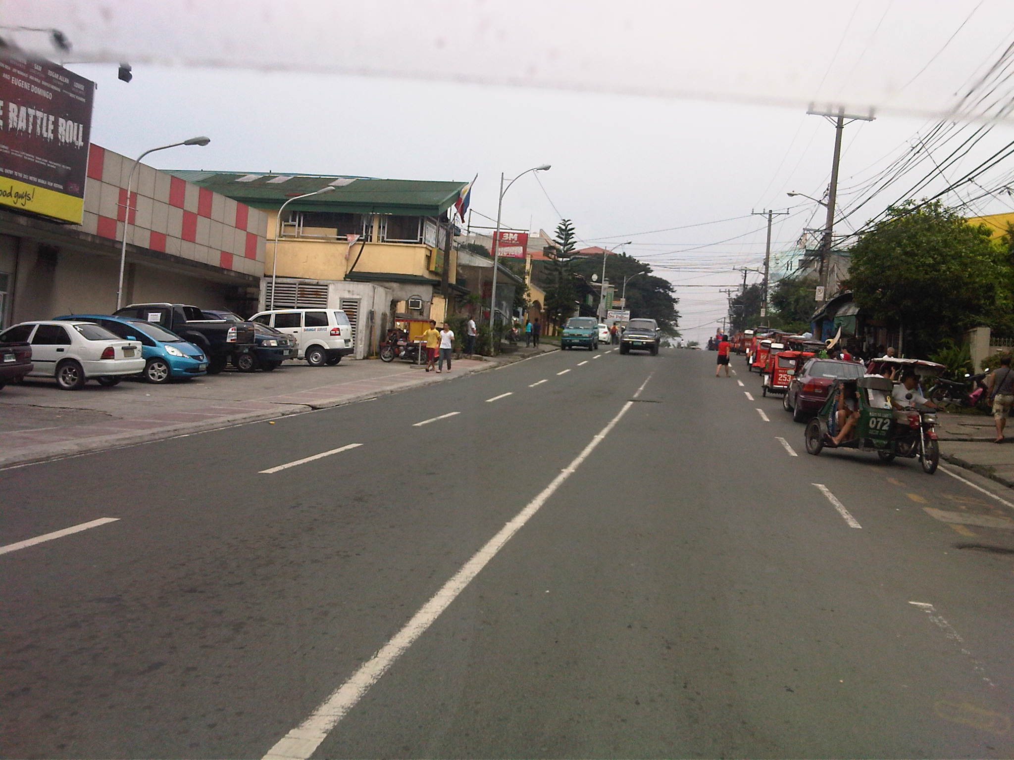 Section in front of SaveMore – while there are off-street parking spaces available at the supermarket side of the road and reducing on-street parking there, the other side’s curbside lane is occupied by a tricycle queue.
 The tricycle queue extends well beyond the head shown in the previous photo. In the picture above, on-street parking in front of residential buildings along the street are shown. There is a yellow line painted on the pavement that seems to be a guide for the tricycles. While I am sure they try their best to park close to the curbside, these 3-wheelers still end up occupying significant road space, thereby reducing traffic capacity.
 Further down the street one starts to realize that the tricycle queue seems to go on and as far as the eye could see in the photo. Note the tricycles parked on the other side of the road, probably just coming back or going around to get fares.
 End of the line – still further down the street and quire near the end of the section designated as V. Luna Extension one can already see the end of the tricycle queue. One can just imagine how many more of these tricycles are going around the village and just how much drivers take home as their net income at the end of a very competitive day. I say competitive here because for the numbers alone at the informal terminal, you get the idea that demand is quite limited and that there is an over-supply of 3-wheelers in the area. Unfortunately, these transport modes are the source of livelihood for many people and to many, a career operating these vehicles seem to be targets for many who have limited opportunities to study and eventually find better-paying jobs.
 Pedestrian crossings – from the previous photos, it is not hard to see that there are few places designated for crossings. In fact, along the entire length of this street (and others like it) people cross just about anywhere. This is possible since traffic is still typically not so heavy along this street.
 Fork in the road – V. Luna Extension continues to the left but as Maginhawa Street in UP Teachers Village. The street on the right is also a part of a residential area, Bgy. Botocan, along which is the ROW of Meralco’s power transmission lines.
–
What if Manila retained its railway lines of old?
It is possible to trace the old railway lines of Manila to the towns to its east in what is now Rizal Province. I had seen it in one railway blog that one of my students showed me after we took up the history of railways in the Philippines where I showed them old maps of the railways in the Philippines. And so based on the descriptions found in those maps and texts combined with familiarity with the places mentioned there and the availability of a tool like Google Earth, it is possible to produce the following images showing two particular lines that could have been “game-changers” for a lot of people taking public transportation between Metro Manila and the areas to its east (i.e., towns in Rizal Province).
 Traces of railway lines of old from Tutuban in Manila to Antipolo (blue) and San Mateo (green)
 The blue line extending to Antipolo City passes through an area that is part of Valley Golf and ends up near the Antipolo Church (Shrine of Our Lady of Peace and Good Voyage). This line could have been a major mode for commuters residing in Antipolo, Taytay, Cainta and Pasig City.
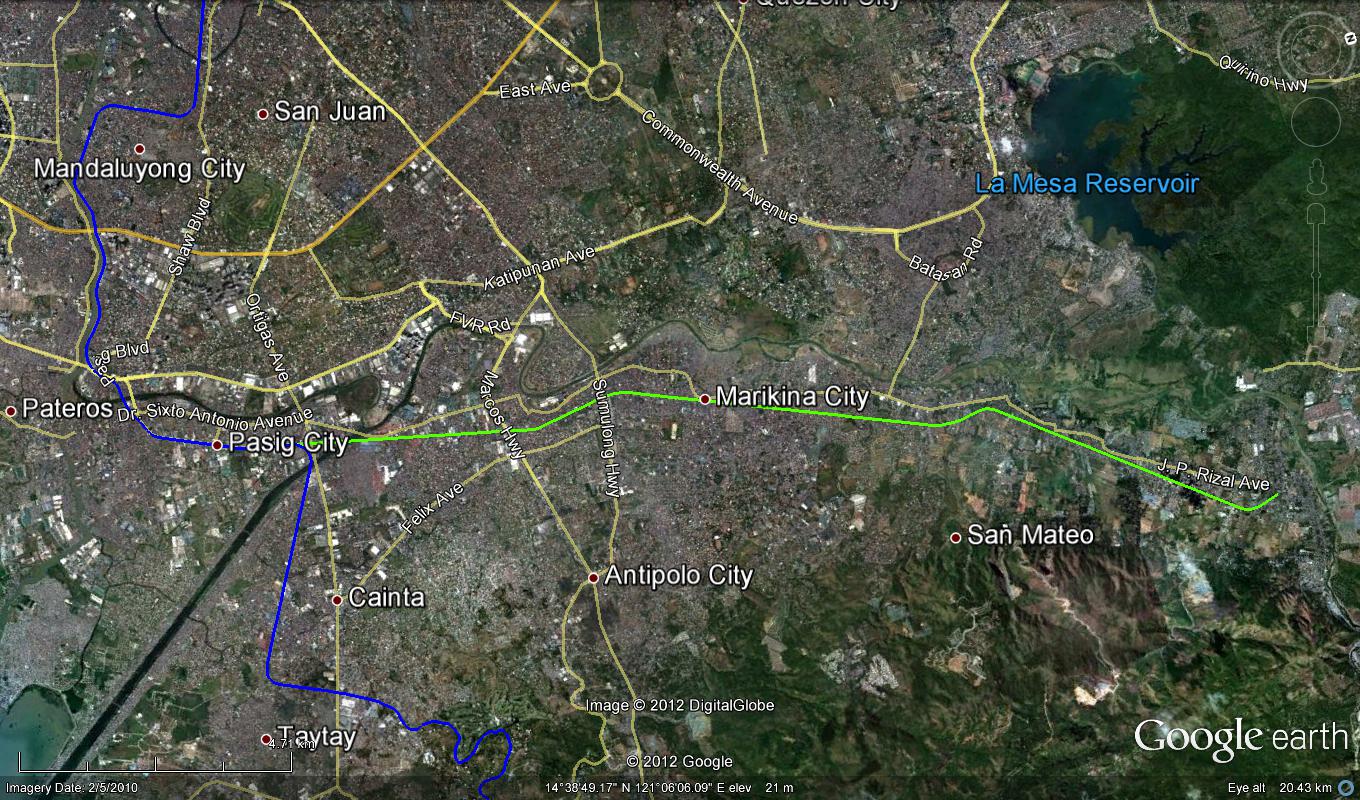 The line extending to San Mateo, Rizal passes through densely populated parts of Pasig and Marikina Cities. The line could have served people residing in these towns all the way to Rodriguez (Montalban).
The outcomes of the exercise of tracing old railway lines as shown in the previous photos allow us to appreciate and maybe contemplate on the “what ifs” and “what could have beens” if the Philippines did more efforts in retaining its railway system after the Second World War. I do not think planners at the time were able to anticipate the rapid development of the area that was to formally become Metro Manila in the 1970’s. While the road network plans were in place, thanks to the design by Daniel Burnham, what Manila and its environs needed was a transit network that did not depend on roads and something that would have been able to carry much more people (and maybe even freight) than the jeepneys and buses that emerged postwar. Perhaps we were not doomed to the current choices that we have and commuting would have been much simpler than the terrible experience many people from these eastern towns have every weekday. I leave it up to the reader to imagine how comfortable and convenient travel would have been along these lines.
–
Railway safety in the Philippines
As the Philippine National Railways (PNR) attracts more passengers and (currently) more support translating to more resources, it is hoped that the company will finally take off and perhaps help improve public transportation and commuting in general. The PNR has been experiencing a renaissance of sorts with the increased frequency and capacity for its commuter line. This, despite still many limitations pertaining to hardware such as its rolling stock and railway tracks (i.e., the PNR has double tracks only along its line Caloocan to Alabang, the rest is single track). The acquisition of newer trains for the commuter line and the upgrading of railway tracks helped revive flagging ridership though service frequencies are still quite limited due to the limitations mentioned. Among the major issues the PNR is still facing at present are encroachments to its right-of-way and safety concerns at the many level crossings along the tracks. While there have been efforts to improve safety by adding devices such as barriers and posting personnel to manage road traffic when trains are passing through, the system is still wanting in terms of safety and there has been a rash of incidents along its commuter and Bicol lines involving road vehicles and pedestrians. Of course, these are not all the PNR’s fault considering there are many “pasaway” people who still insist on crossing the tracks despite warnings of an arriving train. I am featuring below some aspects of rail and road safety that my students have collected during their research on the state of the PNR commuter line.
 PNR Commuter Line train
 The PNR Commuter Line – indicated in red is the double track (two-way) stretch and in orange is the single track (one-way) part of the line that ends in Calamba. The line to Bicol is also single track.
 Map showing the list of level crossings along its Commuter Line between Caloocan, Manila and Calamba
 The PNR defines a diamond-shaped clearance at all level crossings. The diagram above was secured by my students from the PNR, clearly illustrating the area within which there should be (ideally) no obstructions.
 The concept of diamond clearance as applied to level crossings at Malugay, Buendia (Gil Puyat) and Dela Rosa in Makati City.
 The diamond clearance concept as applied along level crossings in Manila.
It is unfortunate that there was a recent derailment of a train in Bicol due to the failure of the railway tracks’ (soil saturation due to heavy rains). This incident will surely set back services until the section has been repaired and perhaps reinforced to prevent such happening again in the future. I always imagine the PNR’s Bicol Express during its glory days as my father has related stories of how good its service was then. This romanticized idea of rail is still alive today and the addition of sleeper and air-conditioned cars have attracted tourists visiting the Bicol Region to use the PNR. It is hoped that this could be sustained and services expanded in the near future. Of course, investments should go into make the Bicol Express line double track in addition to more trains to accommodate two-way traffic. I wouldn’t dream yet of high speed rail for this corridor but decent train services should be able to compete with buses and give travelers a safe and efficient option for travel over land.
–
CLRV: another look at the LPG Jeepney
The research on Customized Local Road Vehicles (CLRV) is currently underway with the project team going around the country to document different jeepney designs. The main objective of the study is to be able to formulate and recommend standards for jeepneys based on the requirements of stakeholders (e.g., passengers) and from the perspective of safety, ergonomics and efficiency. The last term is quite tricky as efficiency here generally refers to the performance of the vehicle, particularly related to fuel consumption. Efficiency may also touch on the capacity of the jeepneys, which would have implications on revenue (i.e., more passengers mean more fares).
Following are photos taken prior to the recent workshop held in Calamba, Laguna where the outcomes of previous workshops in Iloilo and Davao were presented for validation by a similar group of stakeholders. These included cooperatives, assemblers, automobile companies, NGOs, government agencies and other interested parties to the CLRV research. The study is being conducted under the auspices of the Philippine Council for Industry, Engineering and Energy Research and Development (PCIEERD) of the Department of Science and Technology (DOST) and funded by the Department of Transportation and Communications (DOTC).
 One of the jeepneys on display was a 24-seater LPG-powered jeepney by David Motors
 Hyundai Theta engine converted for LPG
 Another look at the engine, which is practically the same engine used by the popular Starex vans. There were two other LPG jeepneys that day with both having Toyota engines converted for LPG. The engines are from the ones used by Hi-Ace models.
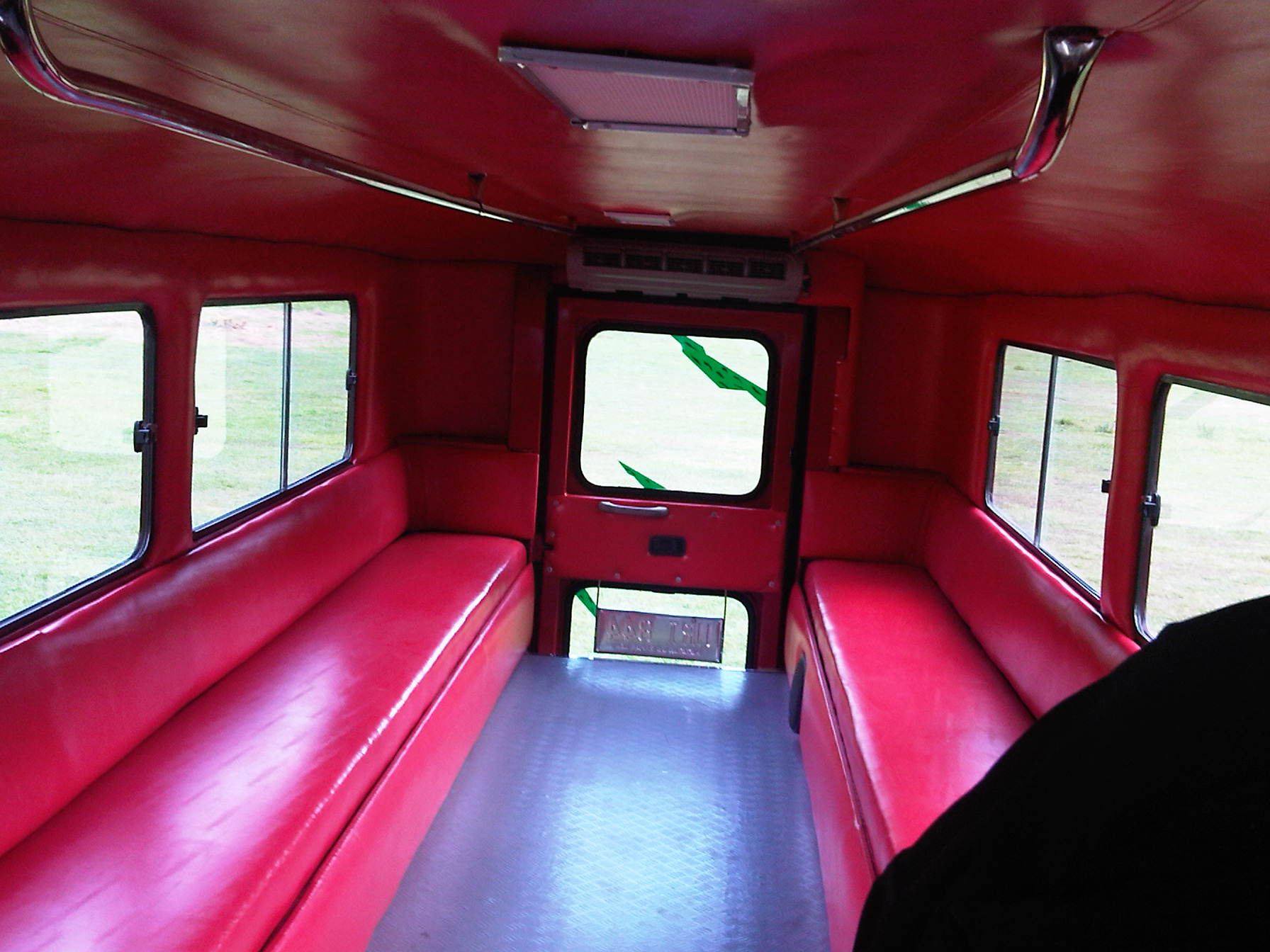
 Bench seats inside the LPG jeepney – there is still a door at the rear but it is used as an emergency exit rather than the main entry/exit for the vehicle. The sliding windows are sealed because of the air-conditioning installed for this jeepney.
 The main door for the jeepney is at the right side just across from the driver. This design mimics those for buses and should enable more efficient collection of fares. That is, passengers may be asked to pay their fares immediately upon boarding the jeepney.
 6A close look at the dashboard, which is a mix of parts coming from different vehicles. The steering wheel, for example, bears the emblem of Hyundai. This jeepney had power features such as power windows that can be controlled by switches on the panel board to the left of the steering wheel.
 Driver’s rear view of passengers and whatever will be trailing the jeepney in traffic.
 The jeepney door is operated through a lever, parts of which are taken from a gear shift. The handle is well within reach of the driver of the vehicle.
 Exec. Dir. Rowena Guevara of DOST-PCIEERD interviews the driver and mechanic of this LPG from David Motors. According to them, the performance of the jeepney is the same as conventional ones and that this less noisy as well as having less emissions. Assemblers of LPG jeepneys say that consumption is about 7.3 km/kg of LPG, which compares well with the estimated 7.5 km/L of diesel consumed by well-maintained conventional jeepneys. LPG is cheaper so it can be inferred that overall, drivers and operators would have increased revenues if they used LPG jeepneys.
 The LPG jeepney is one (there are also electric jeepneys) of the variants being touted as the future of the vehicle. The “eco” tag is among the pitches for these jeepneys and should be a consideration for the study.
–
Another look at Imelda Avenue traffic
A reader brought to my attention some traffic problems encountered along a section of Imelda Avenue in the vicinity of a major retail chain’s branch. There are experiences of traffic congestion along the section fronting the SM Hypermarket from across the Village East subdivision. However, the commercial development and the traffic generated is not really new since the hypermarket replaced another similar establishment (Makro). Arguably though, the trip generation rates of SM developments can be higher than their competitors considering their branding and customer preferences based on traffic experience around SM malls. Following are some specific observations and comments for the case of Imelda Ave. in the vicinity of the SM Hypermarket along the highway.
 Slow-moving traffic in front of the SM Hypermarket along Imelda Avenue in Cainta, Rizal
 Congestion in the previous photo turned out to be caused by jeepneys loading and unloading passengers in front of the commercial development. Jeepneys tend to occupy the outer lane of the highway, significantly reducing road capacity thereby causing a bottleneck leading to congestion propagating upstream. There is actually a loading/unloading bay on the Hypermarket side of the road but jeepneys do not use this and almost always stop in the middle of the road.
 There are also tricycles using Imelda Ave. despite the regulations prohibiting them from national roads. The tricycles serve the residential subdivisions along the highway but used to be the main mode of transport along an unfinished Imelda Ave. from the 1970’s and competed directly with the jeepneys from the 1980’s one the connection between Ortigas Ave. and Marcos Highway had been made, leading to the opening of new jeepney routes through Imelda Avenue.
 The bottleneck for this section is along both directions as jeepneys stop not only for the Hypermarket but also for the residential subdivision (Village East) that is located just across from SM. The gate of the village opens toward SM with traffic generated significant enough to create a 3-leg intersection at the subdivision access/egress. This is an unsignalized intersection that has no enforcer to manage traffic, leaving it up to the motorists to determine acceptable gaps for conflicting movements. Compounding the situation are pedestrians crossing just about anywhere along the road like the people shown in the photo above.
The issues mentioned above are not all unique to the location but are often the case for many other places where there are major traffic generators such as malls, supermarkets and even residential developments. In fact, middle class villages are major traffic generators due to the car ownership but they are usually predictable in terms of peak periods. That is, the morning and afternoon/evening peak are well-defined according to office or school hours associated with residents (i.e., “to school,” “to work,” and “to home” trips). The solution, of course, is quite basic though not so simple – traffic management in the form of personnel who will enforce traffic and manage intersection flow. It is basic because it is a solution that’s definitely “in the box” and traditional or conventional. It is not simple because often, there is a lack of qualified personnel who can manage traffic full-time, and competent to firmly enforce traffic rules and regulations in order to effect behavioral change (for the better) among motorists and pedestrians. Granted, the commercial development should take the initiative to manage traffic and these may be recommendations already made when a traffic/transport impact assessment was conducted prior to the construction of the Hypermarket. Such assessments should have included traffic forecasting (estimating future traffic) in order to determine potential traffic congestion in the area and the formulation of site specific and appropriate mitigation measures. Perhaps there is a document somewhere (EMB?) that Cainta may use as a guide for how to address transport and traffic problems in the area due to the presence of the supermarket. If none, then the burden will be on the local government to study the traffic and come up with a strategy on how to lessen the detrimental traffic impacts of development in the area.
–


