
What if Manila decided to build its first subway back in the 1970s?
There is something about the counterfactual that is attractive to me. While I do not have formal training as an historian, I like to dabble in history and particularly about the what-could-have-been. It started with a book I read about counterfactual military history with various articles written by prominent historians who put forward scenarios including that on Thermopylae, Pearl Harbor, and the Vietnam War. I have found it a good exercise in analysis that is along the lines of chess analytics where one move may lead to another in response. Applying this to transport was quite a natural thing and we take a look at some information from the Feasibility Study for what was proposed in 1973 as the first subway line for Metropolitan Manila.
 Proposed schedule for the 3-stage construction of RTR Line 1, most of which would have been a subway connecting Diliman, Quezon City with the University Belt in Manila and ultimately the airport in Paranaque.
Stage 1 between UP and FEU could have been operational as early as 1983 but typical delays could also have led to service starting in 1984 or even later. According to some critics of the LRT Line 1 that was built instead of the RTR Line 1, Marcos decided against the subway after being convinced by his advisers that the line could not be completed before Singapore finishes its own first line. A story is told that Marcos didn’t want Lee Kuan Yew to have the satisfaction of having Southeast Asia’s first mass transit line so the former opted for the elevated LRT instead. What really happened though was Singapore started operating its SMRT North-South Line in 1987, after what was also a long period of planning, decision-making and construction. It can be argued that the Philippines could still have completed at least 10 kilometers of the RTR Line 1 and at most 15 kilometers by 1987. Even a revolution in 1986 could not have doomed this project given its benefits that we could have reaped over the long-term.
 Proposed stages of construction for the RTR Line No. 1 – whichever alternative could have led to the completion and inauguration of a substantial segment by 1983/84, well ahead of Singapore’s first line.
 Artist’s conception of what an RTR Line 1 platform could have looked like. The trains look like a typical Tokyo Metro train. There’s some humor here as you can see the route map at right and the direction sign at top left referring to the Manira (Manila) Air Port.
As you can see in this rather simple (note: not included are discussions on the financial & economic aspects of this project) exercise, Metro Manila could have constructed the RTR Line 1 more than 3 decades ago. Even with the political upheavals in the Philippines during this period, it can be argued that Marcos and his version of the “best and the brightest” could have pulled it off and come up with the country and Southeast Asia’s first subway line. Most of the decision-making, planning and construction would have been during Martial Law when the Marcos had quite a firm grip on power. So he and his apologists have no excuse for this failure to potentially revolutionize transport and take Metro Manila to the next level in terms of commuting. That failure ultimately led to the current transportation situation we have in what has grown to become Mega Manila.
–
Some thoughts on the Metro Manila subway project
The proposed Metro Manila subway seems to be well underway after months of studies particularly to determine the best alignment given so many constraints and preferences such as it being directly connected to the Ninoy Aquino International Airport (NAIA). A prominent opinion writer is obviously quite excited about the prospect of I also assume that most transportation planners and engineers in Metro Manila if not the whole country are also excited about this project. Commuters are definitely hopeful and many who have experienced riding metros abroad (e.g., Singapore, Hong Kong, Tokyo, etc.) should be among those who look forward to using Metro Manila’s first in perhaps 5 years time.
The idea is not a new one as it is something that was actually thought of way back in the 1970s (perhaps further back?) when the precursor of JICA came up with the Urban Transport Study in Manila Metropolitan Area (UTSMMA) in 1973. The study was closely followed by a feasibility study for what was proposed as the Rapid Transit Railway (RTR) Line 1.
 Cover page for the MRTR Line No. 1 Feasibility Study (NCTS Library)
It was unfortunate, however, that the project was derailed (pun intended) after the World Bank came up with their evaluation of transport situation and transportation planning in the Philippines in 1976, which led to a counter-recommendation to have light rail transit instead of the heavy rail system proposed by UTSMMA. The latter report was followed closely by the WB-funded Metro Manila Transport, Land Use and Development Planning Project (MMETROPLAN) completed in 1977. What really happened such that the “best and the brightest” in those days (Martial Law Philippines under Marcos) abandoned the subway for light rail?
While MMETROPLAN is often lauded as a comprehensive study of metropolitan Manila, many of its assumptions and recommendations should now be subject to scrutiny. These include the assumptions on land use (e.g., for the Marikina Valley and environs not to be developed, etc.) and recommendations for a light rail transit (LRT) network. Time and history provides us with new lenses and filters by which we could try to understand what was going on in the minds of those who did MMETROPLAN. Many of those involved including one prominent (some will say self-promoting) architect and a rather controversial transport planner who were young at the time still refer to MMETROPLAN as The Masterplan that should have been implemented. It obviously wasn’t and we now bear the brunt of opportunities lost because of the decisions made in the 1970s.
I don’t buy the argument of one prominent local transport planner who downplayed the UTSMMA plan as a juxtaposition of the Tokyo metro system to Metro Manila. A more reliable and grounded assessment was recently put forward by another transport planner who is also a geographer and an economist. He was recently in London where they have a comprehensive underground railway network (the London Underground as many fondly call it) and came to the conclusion that the Japanese were inspired by this network and went on to replicate this in Tokyo. This is not without historical basis since the Japanese sent a lot of their future engineers and planners to Europe especially England and Germany during the Meiji Restoration. And so it is not a stretch to think that the principles employed by the Japanese in recommending a heavy rail system back in 1973 is not necessarily just a copy of Tokyo’s but draws inspiration from European models as well. That could have been a game-changer 40 years ago when RTR Line 1 could have started operations and commuting in Metro Manila may not have become as hellish as it is today.
–
Sydney airport airside
As our plane pushed off, taxied and took-off for the return flight to Manila, I took a lot of photos. Here is the collection of photos but I won’t be making a lot of comments on any or each as my purpose it to have these available here for future reference for my lectures or projects.


I also took some photos of Australia as our aircraft flew over the continent. I will be posting those soon to share these views from thousands of meters above.
–
Melbourne airport departure
Here are some photos taken at Melbourne Airport when I traveled to Sydney to spend a few days there prior to returning to Manila.
 Airport terminal driveway
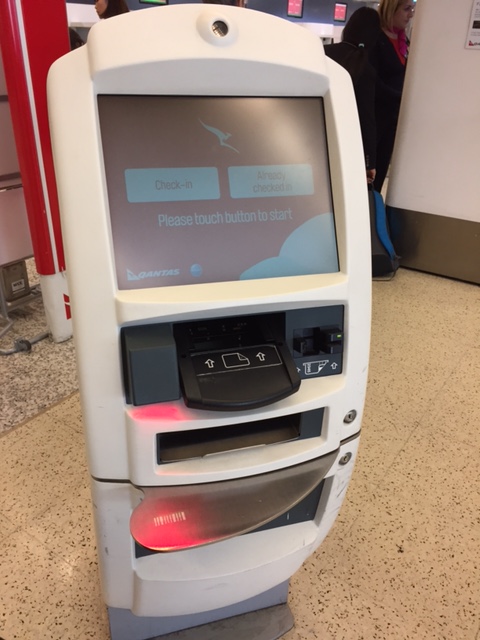 One of many machines allowing for self check-in
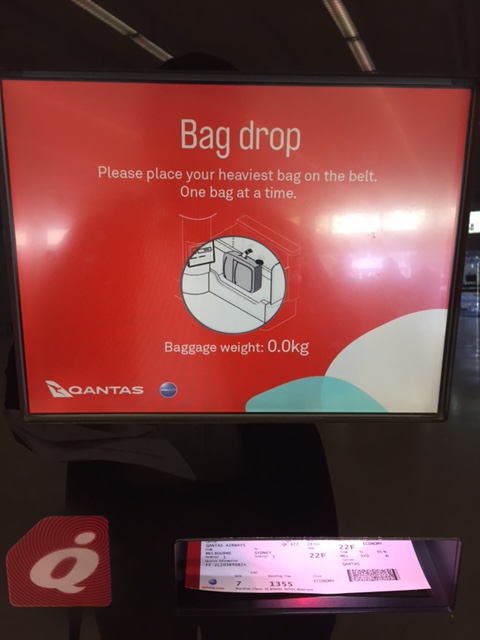 Automated bag-drop allows one to weigh and check-in luggage. You have to put on the tags on your luggage yourself after they are printed out by the machine.
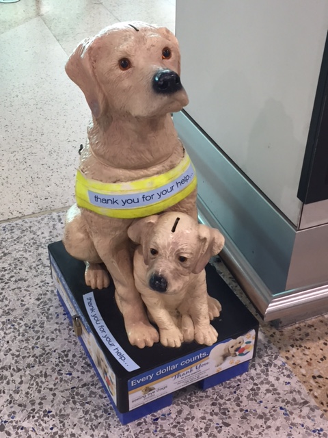 Fundraiser for seeing eye dogs
 The way to the gates is lined with shops
 Passengers checking the status of flights
 The airport terminal doesn’t seem to be crowded (maybe only during the time I was there?) and you can easily get a seat near any of the cafes/restaurants at the terminal.
 A look at the spacious area where passengers can have a meal or refreshment while waiting for their boarding times.
 The escalators lead to the lower level where there are lounges and a path to the exits
 At the lower level are more cafes and shops. I bought myself a pair of shades at the Sunglass Hut there.
 There were already many passengers waiting at the gate when I arrived a few minutes before the boarding call.
 Vending machines, a donation box for UNICEF and another one of those mother dog and puppy devices for donations for seeing eye dogs.
–
What if Ondoy happened today?
With the news of the devastation of Houston by Hurricane Harvey comes articles about transportation in that city. An interesting articles is this one:
Davies, A. (2017) “Hurricane Harvey Destroys Up to a Million Cars in Car-Dependent Houston“. Wired.com. September 3, 2017. https://www.wired.com/story/harvey-houston-cars-ruined?mbid=nl_090317_daily&CNDID=%%CUST_ID%% (Last accessed 9/4/2017).
The article reminded me of a very personal experience back in 2009 when Typhoon Ondoy (international name: Ketsana) submerged much of Metro Manila and its adjoining provinces in what was believed to be at least 100-year floods. Greater Metro Manila or Mega Manila is not too dependent on private cars for transportation with an estimated 70% of trips taking public transport (about 30% use private vehicles including motorcycles and taxis). Much of this public transportation, however, is road-based and so the floods did much to affect transportation in the area for the weeks after Ondoy. Car-owners rebounded quite quickly and car sales surged afterwards with many people purchasing SUVs in response to the likelihood of floods.
But what if Ondoy happened today? What if people were as unprepared as in 2009? Perhaps the damage would have been even greater than back in 2009. Mega Manila has become more dependent on cars since then with the current estimates of private vehicle mode shares at around 35%. The increase includes not only taxis and motorcycles, which have enjoyed steep increases in the past decade, but also ridesharing services (i.e., Uber and Grab).
Uber and Grab vehicles are predominantly comprised of vehicles purchased for the main purpose of being driven for income instead of the original concept of ridesharing where the vehicles are already owned and operated only during the free times of their owners (i.e., they provide services only on a part-time basis). Their proliferation and popularity means a lot more vehicles could have been damaged by Ondoy and that the owners of these vehicles likely would not have recovered from the loss even despite their auto insurance coverages.
Metro Manila and other Philippine cities under the threat of similar severe weather systems such as typhoons should build resilient transportation systems. Not surprisingly, among the more resilient modes of transport are non-motorized such as walking and cycling. Pedicabs where almost immediately back on service in Tacloban after Yolanda practically destroyed that city. But then again, an efficient public transport system is also necessary and buses and trains may provide relief from flooded cities. Maybe, a proposed subway system can also contribute if it includes the construction of subterranean drainage systems similar to that of Tokyo’s. These are not easy to develop or build with infrastructure costing much over the long term. However, Metro Manila needs to start building them now as these won’t get cheaper in the future.
–
Are ridesharing services paratransit modes?
Vuchic (Urban Transit Systems & Technology, 2007) defines paratransit as an “urban passenger transportation service mostly in vehicles operated on public streets and roads in mixed traffic; it is provided by private or public operators and it is available to certain groups of users or to the general public, but it is adaptable in its routing and scheduling to individual user’s desires in varying degrees.”
Based on the definition and how paratransit modes have evolved over many years, then we could say that the current ridesharing or car sharing services like Uber and Grab are essentially paratransit modes. They definitely fit the definition as do conventional taxis.
–
Riding the bus in Sydney
We rode the bus twice in Sydney – first to get from the city to Bondi Beach and the second to go to a train station from Bondi Beach. I wasn’t really able to get a lot of photos inside the buses as they quickly filled with passengers and I wasn’t sure what people thought about someone taking photos inside a bus even for touristy purposes. It is usually better to blend in with the crowd than attract attention to yourself; though it probably didn’t matter much since there were so many Asians in Sydney and wherever we went.
 You can use the Opal card to pay for your bus fare.
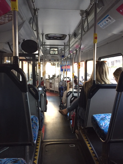 Buses are laid out to optimize the number of passengers it could carry. There are just enough seats for those who need to be seated. Others have to stand but standing space is important for commutes.
–
Ferry ride from Darling Harbor to Cockatoo Island
I had an opportunity to ride the ferries going around Sydney including some of the islands that were part of the attractions of the city. We rode a ferry from Darling Harbor to Cockatoo Island, which used to be for shipbuilding and repairs. It was also historically significant not just because of the ships that were built or repaired there but also because it was used as a correctional facility.
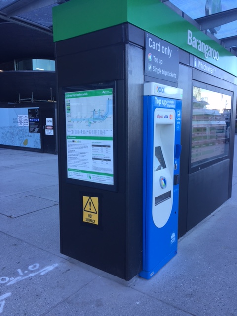 Information and fares – one can get detailed information on ferry services at the wharf and also purchase single trip or top up cards from the machines conveniently located in the area.
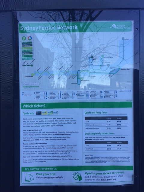 Information on the ferry services including the network and use of Opal cards to pay for your fares
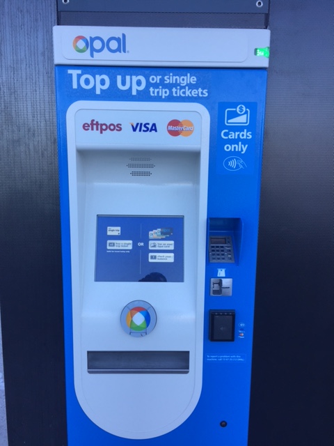 One can use the Opal card to take ferry rides. You can top up (reload) at terminals at the wharf
 The wharf where we were to await our ferry for Cockatoo Island
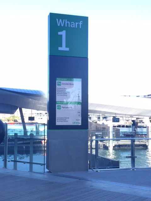 Sign showing which ferry lines dock at Wharf 1: F4 is for Circular Quay and F3 is for Parramatta, which includes a stop at Cockatoo Island.
 The arrival of our ferry at the port
 The cabin was practically empty when we boarded the ferry.
 A better look at the spacious cabin
 Advisory for all passengers
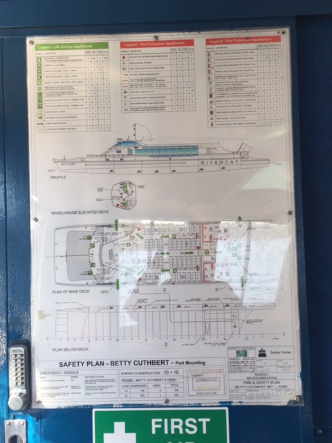 Ferry layout and safety plan
 A view of the bridge and showing the name of the ferry. We discovered that each ferry was named after a prominent female sports figure.
Our ferry ride to Cockatoo Island afforded us splendid views of the waterfront properties and landmarks. The ferry also had few passengers so we could go around the boat to have an appreciation of the sights as well as the vessel itself. I will post some photos of the views from the ferry in a future article.
–
Melbourne taxi rides
I took taxis between the airport and the serviced apartment where I stayed at in Melbourne. Both rides were uneventful ones and I enjoyed the good service provided. Uber is also available but Melbourne taxis appear to be providing an obviously higher quality of service compared to what you can get in Metro Manila.
The following photo shows a couple of stickers that inform the passenger(s) about standard fares and the applicable tolls should the taxis use tollways and therefore incur additional costs.
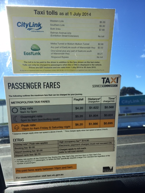
One can pay cash or opt to use a debit or credit card to pay for taxi fares. And you can get a receipt that you can use to account for your transport expenses. That is, the receipt is useful for reimbursements.
For both my rides, I didn’t encounter any unruly taxi drivers. One was a bit chatty but I enjoyed the conversations about life in general. I learned that he was originally from Somalia and had a son studying in university. He said he was very happy with his life in Australia and was thankful of his job that enabled him to support his family including being able to afford to send his children to schools. I guess he is one of the lucky immigrants there and his hard work paid off in this country where the environment generally rewards hardworking people with much opportunities to improve their lot.
Taxi operators and drivers in Metro Manila should learn about what good service is all about from taxis abroad. Perhaps they can pick up a good thing or two for how they can improve services and thereby reducing if nor eliminating the bad impressions people generally have about them that have led to ridesharing services to become quite popular. A significant improvement in taxi services can be rewarding in terms of ridership or patronage.
–
Marcos Highway-Felix Avenue-Gil Fernando Avenue pedestrian overpass
Here’s are some photos of the pedestrian overpass structure at the intersection of Marcos Highway, F. Felix Avenue (formerly Imelda Avenue) and Gil Fernando Avenue (formerly A. Tuazon Avenue).
 Here’s a view of Marcos Highway and the elevated Line 2 Extension from the structure crossing Felix Avenue between Soliven/Tropical and Sta. Lucia. Also shown is the overpass crossing Marcos Highway.
 View towards Sta. Lucia and Robinsons Metro East
 Stairs to Sta. Lucia – notice the gap in the railings along the elevated Line 2 superstructure? That is where the Emerald Station will be constructed.
–
