
Ho Chi Minh City (Saigon) airport arrival
It was my first time to travel to Vietnam and so the opportunity to take photos of the international airport at Ho Chi Minh City presented itself. I wanted to see for myself how the terminal compared to Manila’s considering other airports in the region such as Changi, Kuala Lumpur and Suvarnabhumi are definitely better than NAIA.
 View of the tarmac from our tube after we disembarked from our aircraft
 The airport had a linear layout similar to NAIA’s Terminals 2 and 3, and so we had to walk some distance to the immigration counters. The moving walkway was functioning well and speeded up our walk.
 Descending from the second level after clearing immigration, you get this view of the baggage claim area. Frankly, it reminded me of NAIA Terminal 3’s own baggage claim area.
 The view of the bottom of the stairs
 The baggage claim area was as spacious at that level
 Another photo of the baggage claim area. After clearing customs and exiting to the arrival lobby, you can change currencies at the many banks offering these services or perhaps purchase an item(s) at the shops.
 The taxi stand is along the terminal driveway where you can also wait for an Uber or Grab car. Ridesharing/ridehailing apps Uber and Grab are very popular in HCMC and are definitely cheaper than getting a cab so this option is highly recommended for travelers.
 The arrival area is spacious and features several outdoor cafes/restaurants
 Here is one cafe beside the aircraft departure and arrival information boards
 Another cafe, this one near the taxi stand
–
On motorcycle taxis in Saigon and legalizing these in Metro Manila
Among the things I wanted to observe in Ho Chi Minh City were their motorcycle taxis. These are a popular mode of transport in Vietnam. They are so popular that ride sharing companies Uber and Grab have the motorcycle taxi as an option in their apps. They even have their own helmets for promotion and easy identification.
 Uber moto is among the most popular options for the ride sharing app
 Grab is also popular and the photo shows people wearing other helmets that may be about other companies facilitating motorcycle taxis
 Uber has a motorcycle taxi option in its app in Vietnam. This is a screenshot I took as I loaded their promo code for our conference (Uber was a major sponsor.).
 Grab moto rider browsing for his next passenger
Vietnam has shown that motorcycle taxis can be both popular while being regulated and relative safe (there are tens of thousands of motorcycles moving around their cities including Hanoi and Ho Chi Minh). Should the Philippines, particularly Metro Manila, also consider this at least while it is building more mass transit lines? Again, this is not for everyone and perhaps can help alleviate the worsening transport and traffic conditions in the metropolis. Of course, there are the expected implications if motorcycle taxis are legalized including a further surge in motorcycle sales and ownership and, more troubling, the likely increase in the number of crashes involving motorcycles (hopefully not the fatal ones). But then again, the reality is that there are already motorcycle taxis operating around Metro Manila with upstart Angkas operating against the wishes of the Land Transportation Franchising and Regulatory Board (LTFRB). It is more advantageous to recognize these and perhaps allow Grab and Uber to offer them as options. That way, LTFRB can formulate and issue the necessary rules and regulations covering these and be able to monitor as well as make companies providing them answerable to the public for concerns such as safety and fares.
–
On one way schemes
A proposed one-way scheme for EDSA, C-5 and Roxas Boulevard raised not a few eyebrows among transportation and traffic professionals. While it seems to some that the three major thoroughfares are parallel or can be paired in such a way that EDSA can be one-way southbound, and C-5 and Roxas Blvd. can be one-way northbound, it is not as easy at it seems because these arterial carry a heckuva lot of traffic compared to the roads they are being compared to (New York?). The road network layout is also quite different. We have a circumferential and radial road network as the backbone of road-based transportation. A one-way scheme could be more effective if we had a grid type network where you have several pairs of roads that can be designated as one-way streets.
Take the case of Tacloban City, whose central business district has a grid-type network with intersections relatively closely spaced. The city implemented a one-way scheme as shown below:

Note the pairs of roads designated for one-way flow. These basically make for efficient traffic circulation provided the capacities of streets and intersections are not significantly reduced by factors such as on-street parking and other roadside friction. This can be achieved in various places in Metro Manila where streets are similarly laid out and there are multiple pairs to promote good circulation. Makati, for example, has many one-way streets in its CBD, and these are also in pairs. While having high capacities, EDSA, C-5 and Roxas Boulevard just does not have the closely spaced intersections to effect efficient circulation. In fact EDSA (or C-4) and C-5 are arterials that function to distribute the traffic carried by radial roads such as Roxas Blvd., Shaw Blvd., Commonwealth Ave, Aurora Blvd., etc.
A better option is to focus on improving road -based public transport by setting up high capacity, express bus services with exclusive lanes. These may not necessarily be full Bus Rapid Transit (BRT) systems but requires a drastic reduction and restructuring of current numbers of buses along EDSA and their deployment along corridors like C-5 and Roxas Blvd. Express means longer intervals between stops (hint for EDSA: express bus stops coinciding with MRT-3 stations), and increased travel speeds made possible by exclusive lane(s). This could have been piloted during the APEC meetings in the previous administration where 2 lanes for each direction of EDSA were appropriated for APEC vehicles. These lanes could have been used afterwards for a BRT (-lite?) system and what could have been an pilot could have also provided an appreciation or “proof of concept” for BRT in Metro Manila that we could have learned a lot from.
–
Zamboanga airport departure
Returning to Manila after our business in Zamboanga was completed, we rented a van to take us to the airport. I also took the opportunity to take more photos of the airport.
 I think the sign should state “departing” instead of “departure”
 The check-in counters have windows, which I found to be unusual as similar counters in other airports like Cebu, Davao and Iloilo are open.
 Spacious check-in lobby of the terminal
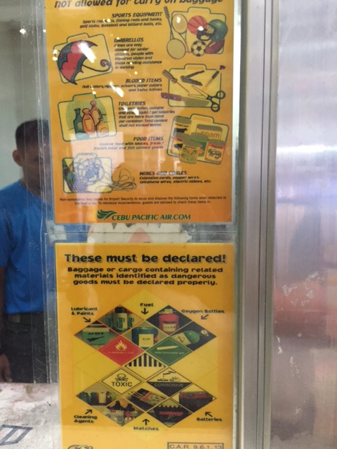 Posted on the windows at the check-in counters are information on items to be declared and those prohibited or not allowed on carry-on (hand carried) luggage.
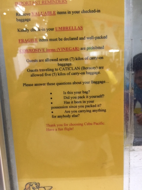 Here’s another sign pertaining to valuable, fragile and prohibited items for checked-in and carry on luggage
 Ground floor pre-departure area
 The airport has a relatively spacious pre-departure area considering the terminal is older than the likes of Iloilo, Bacolod/Silay, Puerto Princesa and Laguindingan.

 At the back are wood and steel benches typical of what you might find in parks rather than in an airport terminal. Perhaps these were placed here to provide more seats to waiting passengers?
 At the Second Floor are concessionaires selling food, drinks and souvenir items.
 A view of our turnaround aircraft
 Approaching to board our aircraft bound for Manila
 A look back at the Zamboanga airport terminal
–
Zamboanga airport arrival
We traveled to Zamboanga City last August for a project there. It was my first time in Zamboanga so I made sure to take lots of photos as we went around. Of course, I took a lot of photos of the airport upon arrival and as we departed the city after a quick 3-day stay. Here are photos taken when we arrived at the airport.
 The airport terminal has a unique architectural design
 View of the control tower from our taxiing aircraft
 There was light rain when we arrived so the tarmac was wet
 Airline staff provided an umbrella for each passenger as we walked from the aircraft to the terminal
 A look back at our aircraft as our baggage was starting to be off-loaded
 Greetings in the local dialect, which is a mix of Visayan and Spanish
 The baggage claim area greets arriving passengers
 View of the terminal exit from the arrival/baggage claim area – the space reminded me of GenSan airport, which has practically the same layout
 Baggage claim area
 Pier type tracks
 Arriving passengers cross the driveway to meet up with relatives, friends or whoever’s picking them up. Some proceed to get a tricycle to the city.
 A lookback at the airport terminal exit
 Airport terminal driveway – view of the departure wing from the arrival wing
 View of the arrival area from the parking area for CAAP employees
 Egress road from the airport
 There are no taxis in Zamboanga and tricycles provide the main mode of public transport for arriving or departing passengers.
 Airport entrance and security check
–
Some thoughts on Metro Manila traffic
I was going to defer posting another article this September as I reached my usual quota of at least 10 posts. Particularly, I wanted to have a series about my recent trip to Vietnam. But then the traffic congestion the past week was just so severe that I felt I just had to write another piece.
To be fair, there are so many reasons why transport and traffic are bad in Metro Manila. Among these is the lack of mass transit infrastructure, particularly a more comprehensive rail-based system. Metro Manila, with its population of over 12 million requires something like 8 to 10 mass transit lines that are interconnected and allows for seamless transfers with road transport modes. Singapore, with less people, has more efficient options for public transport. Then, there is the lack of facilities for walking and cycling that could tremendously reduce the number of trips using motor vehicles particularly for short trips (perhaps within 2 to 3 kilometers travel distance?). I won’t even go to the deficiencies of road public transport and the proliferation of private cars operating as full time taxis (ridesharing anyone?). And urban planning? Well, that deserves its own article…
 This is EDSA in the mid-afternoon. I took this photo while we were heading back to Quezon City from Makati around 3:30PM. It was not supposed to be this heavy considering people were still at their workplaces, schools or even the shopping center/malls.
There is no quick fix to Metro Manila’s problems. Obviously, the infrastructure that should have been in place decades ago need to be built albeit at a high cost. Our children and grandchildren will likely end up paying for these but there is also the reality that such infrastructure won’t get cheaper in the future. There should also be stricter policies and enforcement to improve the quality of services of public transport. As it is, private transport modes including taxis, the popularity of ridesharing/ridehailing services and the unregulated motorcycle taxis are steadily taking people away from public transport. This is perhaps among the most significant causes of more congestion for the metropolis that needs to be quantified and validated for us to understand and determine what measures need to be taken.
I conclude this post and September with a nice article on walkability:
Steuteville, R. (2017) Why walkability is not a luxury, Public Square, https://www.cnu.org/publicsquare/2017/09/28/why-walkability-not-luxury, last accessed September 29, 2017.
–
NAIA terminal transfer guide
I was able to get the following photos of a couple of pages from the Philippine Airlines (PAL) inflight magazine Mabuhay. The photos show an airport terminal transfer guide for the Ninoy Aquino International Airport (NAIA), which has 4 terminals. Since I get a lot of traffic and questions about terminal transfers in this blog, I thought it practical and informative to just post these here for everyone’s benefit.


I hope these are helpful!
–
Some updates on C-6
It seems late but there seems to be no really significant changes to the state of Circumferential Road 6 as the rains seem to have slowed down work on sections of the highway. We took these photos 3 weeks ago showing the nice 2-lane/2-way section on the side of the Laguna de Bay that’s been opened to general traffic. Previously, most vehicles had to use the beat-up, crater-plagued older section of what was a dike road. We were heading to SLEX via Bicutan so we were able to take a lot of photos for the entire stretch of C-6. I won’t be annotating all the photos anymore but suffice it to say that the series starts just after the Napindan Bridge in Pasig and ends prior to Taguig City’s bayside park at Lower Bicutan. Vehicles bound for C-5 or BGC via Ruhale Street should get off the newer section and negotiate a short but very bumpy road that’s not a good experience if you’re using a car. Just after the Ruhale “exit” all vehicles would have to return to the old road and have to be patient with the bad conditions of the pavement on both sides of the road.


–
EASTS 2017 Conference in Ho Chi Minh City, Vietnam
The 12th International Conference of the Eastern Asia Society for Transportation Studies (EASTS) will be held in Ho Chi Minh City, Vietnam from September 18-21, 2017. The conference promises to be an improvement from the 11th conference held in Cebu City, Philippines two years ago. That conference was not as well attended as past conferences and the arrangements were quite shaky considering a lot of supposed commitments for sponsorships backed out during the critical stages of the organization. That included the host city and the transport department (the then Department of Transportation and Communications or DOTC), both of which promised so much when the conference was proposed but somewhat disappeared when the going got tough. EASTS 2017 should exorcise that memory and perhaps the Philippines can host another conference in the future to make amends for Cebu.
Here’s a link to the local organizing committee’s conference site for the details on the EASTS 2017 conference:
12th International Conference of the Eastern Asia Society for Transportation Studies (EASTS 2017)
–
Traffic congestion along Sen. L. Sumulong Memorial Circle
I was on some errands and had to pass through the Sen. Lorenzo Sumulong Memorial Circle from Taktak to the other side of Antipolo near the Lico Circle. The section from Robinsons Antipolo where the Sumulong Circle intersects with Sumulong Highway until C. Lawis Street is being widened and photo below shows the work in progress. The road is a dangerous one especially at night. There are a lot of electric poles in the middle of the newly constructed lanes and power and phone lines dangling in many places. The unfinished parts have a lot of excavations, construction material and debris from the demolished buildings.
 Widened section of Sen. L. Sumulong Memorial Circle
I took the following photos while traffic was at a standstill:
 Initially, it was not so obvious what the cause of congestion was except for the dramatic sag along the road. Both sides appeared to be congested.
 Closer observation showed my direction to be congested up to a certain point whereas the opposite direction across from me was free flowing and traffic build-up along the other side also appeared to be from a certain location at the bottom part of the sag.
It turned out that out of the 6 lanes of the road, only 3 lanes were available to moving traffic – one lane along my way and two along the opposite. Vehicles were parked along 2 lanes of the road in front of the Antipolo City Police Station and 1 lanes across from it. It seems quite ironic considering the police is also tasked with traffic enforcement and management and yet the problem emanated from their station. I am not sure whose vehicles are those that are parked along the road. Perhaps many are owned by police officers? By comparison, the national high school beside the station and the nearby hall of justice did not seem to generate as much vehicular parking as the station. The obvious solution though would be to have an off-street parking lot or facility. Looking at Google Maps, there are some locations along M. Santos Street where a multi-level parking facility can be built but land needs to be acquired first and that can be a difficult task. Another option might be to relocate the main station (i.e., headquarters) elsewhere where there is space for proper facilities including off-street parking. Perhaps they should have a place at the new government center being developed by Antipolo?
–
