
Status of Barkadahan Bridge, Taytay, Rizal
I recently wrote about the Barkadahan Bridge and its current state and compared it to the Marcos Highway Bridge that is now completed and fully opened to travelers. Unfortunately, I didn’t have photos to share but only shared my observations based on what friends have told me and what I’ve read on social media (i.e., Rizal Provincial’s and Taytay’s official Facebook pages) about the situation there. I finally had the opportunity last Sunday when I went to fetch my family at the airport. Here are photos of the Barkadahan Bride and its environs. Note that Barkadahan is actually two bridges and not one. The new one is currently being used for two way traffic (one lane each) while the second one is under rehabilitation and retrofitting. The latter had and will have 2 lanes, too.
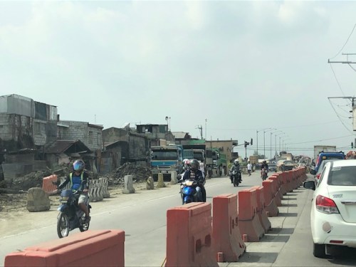 Approach to the Barkadahan Bridge via Highway 2000 – notice the widening on the south side of the highway? That’s the ROW expropriated to align the bridge(s) with the highway. Ultimately, this should be of the same width as C-6.
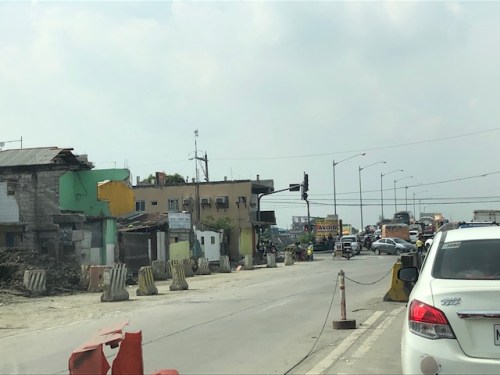 Closer to the bridge, you see more of the ROW acquired to improve the geometry for the area and the intersection with the East Bank Road. Highway 2000 is now aligned with the second (newer) bridge constructed that will eventually carry only the eastbound traffic. The older bridge currently being rehabilitated and retrofitted will carry the westbound traffic.
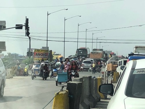 Vehicles crowd on the two-lane bridge that is the new Barkadahan Bridge. The old one is currently being rehabbed. Notice the significant volume of trucks using the bridge? This is expected to increase due to the industrial developments in Rizal Province and along C-6, and the direct route this corridor provides towards the SLEX via Bicutan.
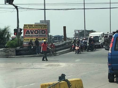 Big sign at the bridge – there are many of these scattered around Pasig and Rizal advising travelers against using the route and Barkadahan Bridge because for the construction work on the bridge. This ‘avoidance’ basically transferred (some say returned) much of the traffic to Ortigas Avenue Extension. Many if not most users of the bridge use this alternate route to travel from Rizal to BGC and Makati CBD.
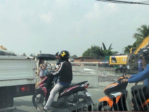 A peek at the construction work on the old bridge – note that the contractor seems to have completed installing the steel reinforcement for the slabs for this section of the bridge. The next phase would be the concrete pouring.
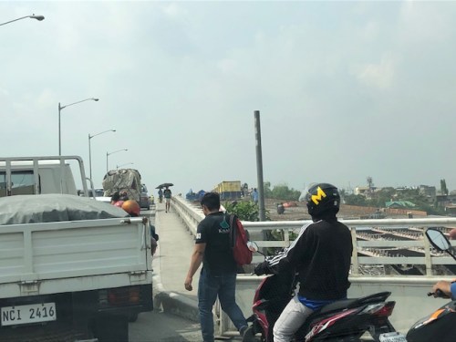 Still another peek showing the extent of the work on the old bridge – my casual observation of the work areas was that there seems to be not so many workers. But then maybe it was a Sunday? Perhaps there should be more people working considering this is a very urgent project?
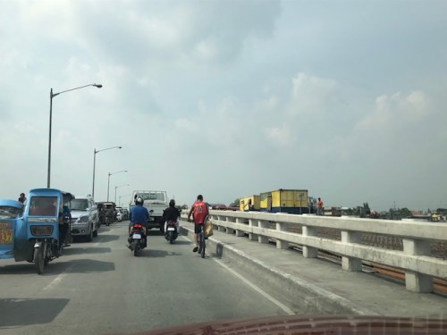 Tricycles, motorcycles and bicycles – there’s a lot of local traffic using the bridge and these are represented by mostly tricycles serving the residential and commercial areas along the East and West Bank Roads and the cyclists you most often see crossing the bridge. Most motorcycles are through traffic. On weekends one can observe more recreational cyclists as this route is a popular one to Rizal and particularly its mountainous areas that are popular to mountain and road cyclists.
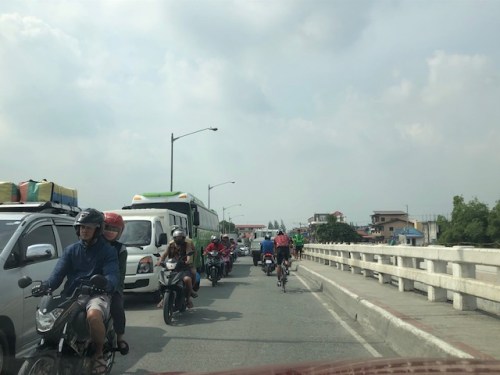 Counterflow – many motorcyclists tend to counterflow and this adds to the friction and slows down traffic. Once the other bridge is completed and re-opened, these will likely be reduced to lane splitting or filtering as the opposite flows of traffic will be assigned to separate bridges. Counterflow traffic will then be very obvious and should be apprehended.
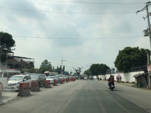 Here’s the resulting queue on the other side of the bridge. This is severe congestion that reaches C-6. Note that the photo was taken on a Sunday. Perhaps these travelers have no other option but to use this route so they are stuck in hellish traffic on a Sunday? I can only imagine how worse it is on weekdays.
As a parting shot, I think there are still a couple of things that need to be addressed once the bridges are both open to traffic:
- Optimizing traffic management at the intersections with the East Bank Road and West Bank Road of Manggahan Floodway – the (mis)management of traffic here also contributes to congestion in the area. Traffic enforcers on both ends of the bridge have basic knowledge of how traffic must be managed and end up with the “buhos” approach. They don’t seem to be coordinating with each other, too. Their approach also heavily favors the East and West Bank roads when traffic is heavier along the main corridor that is C-6/Highway 2000. There needs to be a more efficient way to manage traffic here and that may be in the form of a sophisticated traffic signal system at least for the two intersections. Settings need to be studied and signals have to be adaptive to the variation of traffic throughout the day.
- Resolve bottlenecks in the area including structures that tend to reduce capacities of the approaches to the bridge.
More on this topic soon!
–
On the importance of trees in the urban setting
Having lived in two other countries and traveled in many others, I have seen and experienced for myself examples of tree lined avenues and streets in the urban setting. And I am not talking about small cities but big ones like Tokyo and Singapore. I have gone to many of the big cities in Japan to be able to say that trees should have their place in the so-called urban jungle and the benefits of having them are tremendous. Here is a nice article recently published in The Guardian that explains the advantages of green streets:
Balch, O. (2019) “Green streets: which city has the most streets?”, The Guardian, https://www.theguardian.com/cities/2019/nov/05/green-streets-which-city-has-the-most-trees [Last accessed: 11/08/2019]
Philippine cities should heed the advice from the author and city and municipal planners should make sure that plans incorporate trees and other flora. Obviously, they are not just ornamental but rather should be indispensable components of our towns whether it is highly urbanized or not. I guess the same concepts apply also to the roadsides of our national highways. The Department of Public Works and Highways (DPWH) clearly had little or no regard for greenery; chopping down even the elder trees along the way of their road widening programs. As such, they have contributed to blight along these roads and it would take some time and effort to bring back what used to be tree-lined, canopied roads in many provinces.
–
On Tikling Junction traffic (mis)management
There was an uproar among commuters when Taytay installed traffic signals at the rotunda at Tikling Junction. The junction is the intersection of Ortigas Avenue Extension, which continues towards Antipolo, the Manila East Road, which connects many of Rizal Province’s towns, and Leonard Wood Road, which leads mainly to residential areas in Taytay. There is another road that is close to the junction, Cabrera Road, that qualifies the intersection to be an offset type. However, vehicle coming in and out of Cabrera Road mainly are with respect to the Manila East Road.
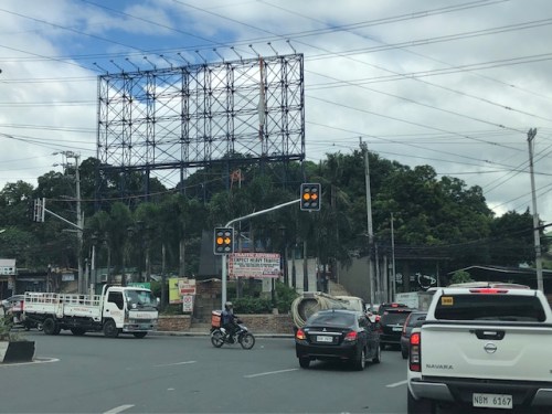 Traffic signals as seen from the Manila East Road approach to the rotunda
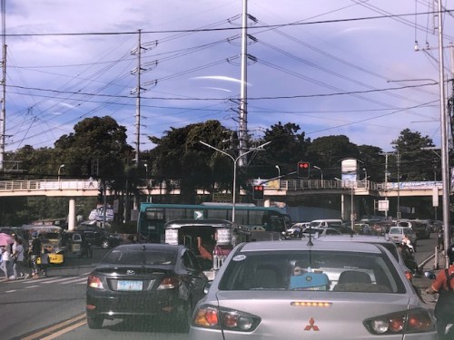 Traffic signals as seen from the Ortigas Ave. Ext. leg approach from Antipolo
The horrendous congestion last Thursday was due to the settings of the signals that forced most vehicles to stop even though there were movements that were not in direct conflict with others (e.g., through traffic along Ortigas Ave. Ext. from Antipolo towards the direction of Valley Golf/Cainta and right turning traffic from Ortigas Ave. Ext. to Manila East Road). The results were vehicles backed up all the way to Cainta Junction along Ortigas Avenue Extension and SM Taytay along the Manila East Road. We were able to experience the slight congestion the following day (Nov. 1) when we descended to Tikling from Antipolo. Congestion was slight probably because of the significantly reduced traffic due to the holidays.
I thought, based on experiences at this junction, that the traffic signal settings somewhat mimicked the style applied by Taytay traffic enforcers when they manually manage traffic at the intersection. Too often, they apply the “buhos” system where they try to let through all vehicles they see queued per approach. The outcome of this, of course, is longer stopped times to all other vehicles from the other legs resulting in longer and longer queues that become unmanageable especially during the peak hours (i.e., when vehicle arrivals are highest at the intersection). Basically, what happened last October 31 was that the “buhos” traffic enforcers were replaced by the machines (i.e., traffic signals) that employed the same system only this time there was no opportunity for some flexibility for movements that had none or the least conflicts at the intersection.
–
Modified jeepneys?
I spotted this modified jeepney along my commute between Antipolo and Quezon City. The jeepney has been modified so its door is no longer at the back like most jeepneys but at the right side. Judging from the design and the license plate, this was not a “new” jeepney though its the first time I saw this along my regular commute.
 Modified jeepney plying the Antipolo-Cubao (via Sumulong Highway) route
The design is a safer one as passengers board and alight from the right side and to the sidewalk (assuming the jeepney driver positions the vehicle in the right manner for a stop). A back door meant passengers boarded and alighted in front of another vehicle or is exposed to traffic. This reminded me also about the designs for LPG jeepney models that were rolled out more than a decade ago but didn’t really take off. The electric jeepneys also have models with the side door that is now found in most models including non-electrics in the modernization program. Perhaps the government should require all jeepneys to be at least retrofitted this way?
–
Cooperative work among LGUs to address transport problems along Ortigas Avenue Extension?
I saw a recent post about a meeting hosted by Pasig City. The Mayor of Pasig City recently held a meeting where he invited the mayors or Antipolo, Cainta and Taytay to discuss, among other things perhaps, transportation along Ortigas Avenue. Ortigas Avenue is a corridor shared by several LGUs most notably the Rizal towns of Antipolo (which is the provincial capital and a highly urbanized city), Cainta and Taytay. The latter two are among the richest municipalities in the country; a fact I underline here since that also should translate to them having the resources or means to help come up with transport and traffic solutions.
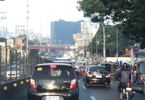 Morning rush traffic starts very early these days. This photo was taken around 6AM on a Thursday along the westbound direction just after the Manggahan Bridge. The pedestrian overpass at C. Raymundo junction is shown and the dark colored buildings are at Robinsons’ Bridgetown development. Note the commuters along the right waiting for a ride.
Photos paint a thousand words. The Taytay Mayor attended the meeting. He has been under fire for the horrendous traffic caused by the mismanagement of Tikling Junction as well as the Barkadahan Bridge area that was and is supposed to be a major alternative route for Rizalenos heading to their workplaces in Makati and BGC. More recently, there were posts about the traffic signals installed at Tikling Junction that basically invalidates the roundabout concept for the junction. The result last Thursday, the first day of operations for the signals, was hellish traffic that backed up a couple of kilometers along the Manila East Road and Ortigas Ave. Extension (some reports say until Cainta Junction). This, even as the signal settings were supposedly done with help from the MMDA.
Antipolo was represented by its former Mayor and husband to the current one. He also happens to be a former Governor of the Rizal Province and likely to run again as his mother, the current governor, is on her 3rd term. It seems to me that the province is not so interested in solutions for Ortigas Avenue despite most of its constituents traveling through the corridor to get to their workplaces and schools. Marcos Highway is not the main corridor for Rizal towns as it basically carries only Antipolo and maybe some of Tanay (via Sampaloc) traffic. Ortigas Avenue Extension branches into two major roads from Tikling – Ortigas Ave Extension, which ends at the capitol, and the Manila East Road, which connects to practically all of Rizal towns with San Mateo and Rodriguez (Montalban) being the exceptions. It is time for the province to pay attention to this commuting problem experienced daily by her constituents.
The Mayor of Cainta seems not as interested as the others, sending a representative who appears to be not one of the top officials (the traffic chief with a rank of SPO1=Master Sergeant is lower ranked than a councilor) of the Municipality to such an important meeting. In fact, he is currently now embroiled in a controversial faux pas involving himself by not wearing a helmet while riding a motorcycle. What’s more is his downplaying this and appearing to be even justifying the act. He eventually apologized but not before stating his moves. He is not new to publicity (stunts?) and knows how bad publicity still translates to good publicity especially in this days of fake news and trolls (he apparently has many on social media). He seems to forget that transport and traffic solutions for Ortigas Ave will likely benefit anyone seeking reelection or higher office in Rizal. He is on his last term as mayor and the break-up with some of his allies including his former Vice Mayor who ran against him in the last elections shows the limits of his political career. What was rumored as plans to run for Rizal governor might just be downgraded to perhaps Vice Mayor? In any case, he should show more interest and effort in finding solutions beyond traffic management and not by himself but in cooperation with others with whom his jurisdiction shares the problems with. Perhaps the initiative of the Pasig Mayor presents an opportunity for such cooperative work? Many people are very interested in this and will be watching – and hoping.
–
On the issuance of provisional units for ‘modernised’ jeepneys
There seems to be a proliferation of various models of the so-called “modernized jeepneys”. They have been deployed along what the DOTr and LTFRB have tagged as “missionary routes”. The latter term though is confusing because this used to refer to areas that are not yet being served by public transportation, hence the “missionary” aspect of the route. The routes stated on the jeepneys are certainly new but they overlap with existing ones. Thus, the new vehicles are actually additional to the traffic already running along the roads used by the existing (old?) routes. The number of units are said to be “provisional” meaning these are trial numbers of these new vehicles and implying the route and service to be somewhat “experimental”. There can be two reasons here that are actually strongly related to each other: 1) the actual demand for the route is not known, and 2) the corresponding number of vehicles to serve the demand is also unknown. Unknown here likely means there has been little or no effort to determine the demand and number of vehicles to serve that demand. The DOTr and LTFRB arguably is unable to do these estimations or determinations because it simply does not have the capacity and capability to do so; relying on consultants to figure this out. That work though should be in a larger context of rationalizing public transport services. “Provisional” here may just mean “arbitrary” because of the number (say 20 or 30 units?) of units they approve for these new routes.
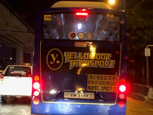 A ‘modernised’ jeepney with a capacity of 23 passengers. The vehicle is definitely larger than the conventional jeepneys and yet can only carry 23 seated passengers. That’s basically the number of seats for most “patok” jeepneys that are “sampuan” or 10 passengers on each bench plus 2 passengers and the driver in the front seats.
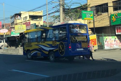 Modernized jeepney unloading passengers along the roadside
Rationalization should require not only the replacement of old jeepney units that seems to be the objective of the government’s modernization program. Rationalization also entails the determination and deployment of vehicles of suitable passenger capacities for the routes they are to serve. I have stated before that certain routes already require buses instead of jeepneys and that jeepneys should be serving feeder routes instead. Meanwhile, routes (even areas) currently having tricycles as the primary mode of transport would have to be served by jeepneys. Tricycles, after all, are more like taxis than regular public transportation. Such will also mean a reduction in the volumes of these vehicles and, if implemented and monitored strictly, may lead to an improvement in the quality of service of road public transport.
[Note: May I add that although I also use ‘jeepney’ in my articles, these vehicles should be called by their true names – ‘jitneys’. The term jeepney is actually a combination of the words Jeep (US military origins) and jitney (a public utility vehicle usually informal or paratransit offering low fares).]
Boundaries of Rizal towns
You don’t see arches (arko) marking the boundaries of Rizal towns. A couple of weeks ago, I traveled to Baras where our office had its annual strategic planning workshop. Along the way, I drove along four towns – Antipolo, Teresa, Morong and Baras. There were few notable landmarks along my route unlike what I usually observe on trips to the north including the central Luzon and Ilocos towns where old buildings like churches and municipal halls (even houses) dot the way. Among the notables usually are the arches announcing your entry or exit to/from towns and provinces.
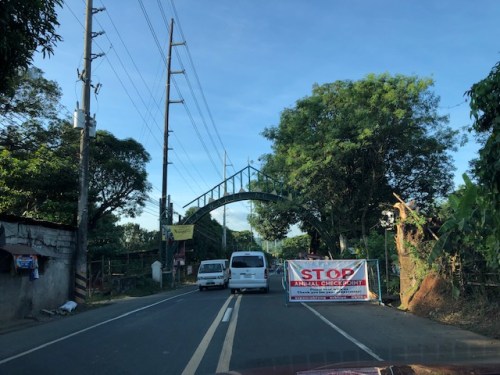 Arch between Baras and Morong along the Manila East Road
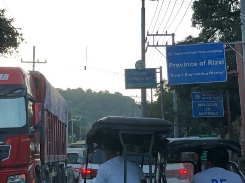 Signs marking the boundary of Teresa and Antipolo
Were there arches before for Rizal towns? Perhaps. What happened to them? Many probably were demolished due to road widening projects as the additional lanes meant the arches for the previous 2-lane roads became obstacles that increased the risk for crashes (i.e., vehicles crashing into them). I wonder now if the arches in Tarlac and Pangasinan towns survived the road widening projects there.
–
On airport congestion again
I have been traveling a lot the past months and most of these trips require air travel. We’ve experienced quite a number of delays including waiting for about an hour inside an airplane. That happened after boarding and being informed by the pilot that they have been instructed by Manila air traffic control to standby where we were. Where we were was one of the major cities in Mindanao so that meant instant delay to our travel. Other times, we were on time; leaving around the original ETD and landing around the original ETA. To be fair, my most recent flights were quite okay with our plane landing 15-20 minutes ahead of the ETA. This recent variation in the travel times show that congestion is not necessarily a big a problem as it was months ago or even a year or so ago. Perhaps there have already been adjustments, for example, in airlines’ juggling their fleets to reduce turnaround times. Air traffic control may also have been optimized for various airports. This challenge to reduce airport congestion both on the ground and in flight is a continuing effort by airports and is not limited to Manila.
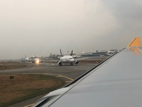 Aircraft queuing for take-off at Changi Airport in Singapore
–
On the NAIA Terminal 3 overnight parking fees again
I’ve received a lot of views and inquiries about the parking rates at the NAIA Terminal 3. There seems to be a lot of people wanting to know about the rates and ideas about how much they might be paying if they chose to leave their vehicles while on trip abroad or within the Philippines. There are a few articles I’ve written about them and even posted some example parking receipts. We also have had someone from NAIA parking explaining how fees are computed (scroll through the comments sections of my posts, its there somewhere). In the interest of many travelers still inquiring about this topic and to have a recent example, I am posting a receipt from a very recent trip when I parked my vehicle at the multilevel parking facility of T3:
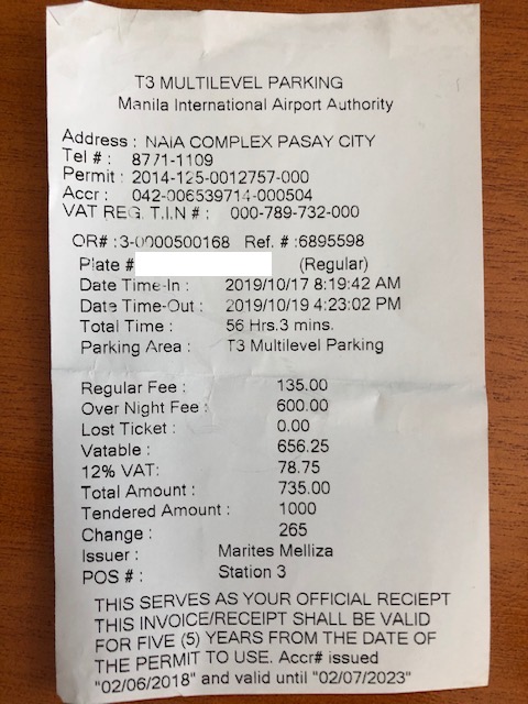
If you break down the total amount paid, 600 pesos went to the 2 overnights that I assumed to cover 48 hours of the total 56 hours and 3 minutes logged for the parked vehicle. The regular fee of 135 pesos covered the remaining 8 hours and 3 minutes. If the basic rate was 35 pesos for the first 3 hours and 20 pesos per succeeding hour, then that practically translates to the 135 pesos. I hope this helps my readers!
–
Is there really a transport or traffic crisis in Metro Manila?
I was interviewed recently for a research project by students enrolled in a journalism class. I was asked by one in the group if we indeed have a transport crisis in Metro Manila. The other quickly added “hindi transport, traffic” (not transport but traffic). And so I replied that both terms are valid but refer to different aspects of the daily travel we call “commuting”. “Traffic” generally refers to the flow of vehicles (and people if we are to be inclusive) while “transport” refers to the modes of travel available to us.
“Commuting” is actually not limited to those taking public transportation. The term refers to all regular travel between two locations. The most common pairs are home – office and home – school. The person traveling may use one or a combination of transport modes for the commute. Walking counts including when it is the only mode used. So if your residence is a building just across from your office then your commute probably would be that short walk crossing the street. In the Philippines, however, like “coke” and “Xerox”, which are brands by the way, we have come to associate “commute” with those taking public transportation.
And so we go back to the question or questions- Do we have a transport and traffic crises? My response was we do have a crisis on both aspects of travel. All indicators state so and it is a wonder many including top government transport officials deny this. Consider the following realities for most commuters at present:
- Longer travel times – what used to be 30-60 minutes one-way commutes have become 60 – 120 (even 180) minute one-way commutes. Many if not most people now have double, even triple, their previous travel times.
- It is more difficult to get a public transport ride – people wait longer to get their rides whether they are in lines at terminals or along the roadside. The latter is worse as you need to compete with others like you wanting to get a ride ahead of others.
- People have to wake up and get out of their homes earlier – it used to be that you can wake up at 6:00AM and be able to get a ride or drive to the workplace or school at 7:00/7:30 AM and get there by 8:00 or 9:00AM. Nowadays, you see a lot of people on the road at 5:30AM (even 4:30AM based on what I’ve seen). That means they are waking up earlier than 6:00 AM and its probably worse for school children who either will be fetched by a service vehicle (e.g., school van or bus) or taken by their parents to their schools before going to the workplaces themselves.
- People get home later at night – just when you think the mornings are bad, afternoons, evening and nighttimes might even be worse. Again, it’s hard to get a ride and when you drive, traffic congestion might be at its worst especially since most people leave at about the same time after 5:00PM. Coding people and others not wanting to spend time on the road (instead working overtime – with or without additional pay) leave for their homes later and arrive even later.
- Less trips for public transport vehicles – traffic congestion leads to this. What used to be 6 roundtrips may now be 4. That affect the bottomline of income for road public transport providers. Given the increased demand and reduced rolling stocks of existing rail lines that includes rail transport.
To be continued…
—
 Caught (up) in traffic